*For Sunday, 25 October 2009.
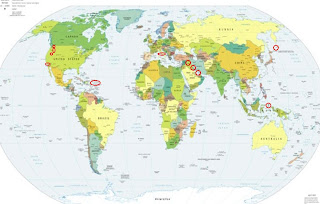
LEGEND for OVERVIEW: Size = My surety of area for quake.
Red Circle = Probable quake to STRONG quake.
Triangle = Very Strong/Stronger quake (Usually takes extra days).
Blue Circle, etc. = Uncertainty of symptom area for probable quake.
Gold Circle = Volcanic symptom.
(If I find a matching symptom in my database I will give a
probable magnitude.)
Places to watch.
Good luck to all.
(Personally busy day and probably
missed symptoms.)
For Sunday, 25 October 2009.
--------------------------------------
IRAN-IRAQ BORDER REGION
(31.46N 47.47E) (Probable 4
and probable multiples)
then IRAQ (36.72N 42.44E)
(Probable 5 and probable multiples)
then SOUTHERN IRAN area
(27.40N 53.70E) (Becoming a
daily symptom - Strong)
--------------------------------------
(Nothing found - may be still coming.)
West Richland, WA (46.394N 119.292W)
to Klamath Falls, OR (42.255N 121.944W)
(May include Mt. St. Helen’s. 2 different
symptoms. Probable 3 and probable
multiples)
then Darrington, WA (48.319N 121.282W)
(Probable 3 and probable multiples)
--------------------------------------
1.7 2009/10/24 22:31:28 47.636N 122.210W 25.7 1 km ( 1 mi) NE of Clyde Hill, WA
2.5 2009/10/24 14:15:47 45.126N 120.946W 19.3 12 km ( 7 mi) ESE of Maupin, OR
1.8 2009/10/24 14:12:58 45.125N 120.939W 18.1 12 km ( 8 mi) ESE of Maupin, OR
1.1 2009/10/24 14:11:46 45.127N 120.935W 18.6 13 km ( 8 mi) ESE of Maupin, OR
1.0 2009/10/25 11:49:11 46.199N 122.184W 1.6 0 km ( 0 mi) WSW of Mount St. Helens Volcano, WA
1.4 2009/10/25 05:34:19 47.718N 121.513W 9.9 6 km ( 4 mi) SSW of Baring, WA
1.5 2009/10/25 03:56:05 47.722N 121.535W 10.7 6 km ( 4 mi) SW of Baring, WA
1.1 2009/10/25 01:54:56 47.661N 120.035W 6.9 3 km ( 2 mi) ENE of Waterville, WA
1.4 2009/10/25 01:02:47 45.379N 121.708W 2.6 18 km (11 mi) SSW of Parkdale, OR
CENTRAL ITALY (42.25N 13.52E)
(Probable 3)
--------------------------------------
2009-10-25 17:50:27.0 38.21N 15.12E 8 ML2.9 SICILY, ITALY
2009-10-25 16:51:20.0 42.56N 13.21E 10 ML2.1 CENTRAL ITALY
2009-10-25 16:42:37.0 42.56N 13.22E 11 ML2.3 CENTRAL ITALY
2009-10-25 14:43:33.0 42.56N 13.21E 11 ML2.1 CENTRAL ITALY
2009-10-25 11:54:32.0 42.65N 13.23E 13 ML2.2 CENTRAL ITALY
2009-10-25 10:32:36.0 42.56N 13.21E 10 ML2.0 CENTRAL ITALY
2009-10-25 08:30:24.0 42.57N 13.21E 10 ML2.1 CENTRAL ITALY
2009-10-25 06:12:40.0 42.57N 13.22E 12 ML2.1 CENTRAL ITALY
2009-10-25 05:53:06.0 42.57N 13.23E 11 ML2.7 CENTRAL ITALY
2009-10-25 05:30:23.0 42.47N 13.35E 16 ML2.0 CENTRAL ITALY
2009-10-25 01:52:02.0 42.57N 13.23E 12 ML2.3 CENTRAL ITALY
KURIL ISLANDS (47.66N 154.16E)
(Probable 5.5 and probable multiples)
--------------------------------------
2009-10-25 13:20:38.8 42.78N 146.01E 33 mb4.2 OFF COAST OF HOKKAIDO, JAPAN
2009-10-25 11:56:52.7 54.38N 159.60E 120 m3.3 NEAR EAST COAST OF KAMCHATKA
Puerto Rico/Virgin Islands (MEDIUM)
--------------------------------------
2009/10/24 00:59:20.13 18.260N 68.032W 106.0 3.4 C Mona Passage
2009/10/24 03:28:11.27 19.150N 64.342W 24.9 3.2 C Sombrero Fault Zone
2009/10/24 08:46:24.15 19.394N 65.572W 40.0 3.3 C 19° N Fault Zone
2009/10/24 12:28:54.57 19.314N 65.488W 15.5 3.0 D 19° N Fault Zone
2009/10/24 14:19:07.12 19.113N 64.433W 13.5 2.8 D Sombrero Fault Zone
2009/10/24 18:11:19.87 19.188N 68.867W 127.0 3.9 D Septentrional Fault Zone
2009/10/24 19:08:02.96 18.802N 64.861W 34.2 3.6 C Virgin Island Platform
2009/10/24 21:14:10.69 19.142N 66.469W 26.7 2.8 C 19° N Fault Zone
Mettler, CA (35.066 -118.915)
(Probable 3 and probable multiples)
--------------------------------------
1.2 2009/10/26 17:41:03 34.092 -117.256 7.0 5 km ( 3 mi) N of Loma Linda, CA
1.6 2009/10/26 12:57:15 34.013 -117.242 17.4 4 km ( 2 mi) S of Loma Linda, CA
2.2 2009/10/26 09:19:55 35.380 -118.633 4.2 16 km ( 10 mi) NNW of Keene, CA
1.6 2009/10/26 08:43:52 34.191 -117.296 10.6 6 km ( 4 mi) S of Crestline, CA
2.0 2009/10/26 07:22:57 34.175 -118.264 4.2 1 km ( 1 mi) WNW of Glendale, CA
1.1 2009/10/26 06:46:52 34.036 -117.589 5.5 4 km ( 3 mi) ESE of Ontario, CA
1.5 2009/10/26 04:33:08 34.230 -117.601 12.7 8 km ( 5 mi) SE of Mt. Baldy, CA
2.0 2009/10/26 02:31:17 34.138 -117.485 4.0 5 km ( 3 mi) NNW of Fontana, CA
HALMAHERA, INDONESIA
(2.10N 128.78E) (Probable 3)
--------------------------------------
2009-10-25 05:00:47.1 7.37S 129.33E 80 mb4.6 KEPULAUAN BABAR, INDONESIA
2009-10-25 00:35:07.2 6.72S 131.68E 40 mb5.0 KEP. TANIMBAR REGION, INDONESIA
Peace to all.

posted by Unknown @ 4:30 AM
0 comments
![]()
![]()
