*For Tuesday, 19 December 2006.
LEGEND for OVERVIEW: Size = My surety of area for quake.
Red Circle = Probable quake to STRONG quake.
Triangle = Very Strong/Stronger quake (Usually takes extra days).
Blue Circle, etc. = Uncertainty of symptom area for probable quake.
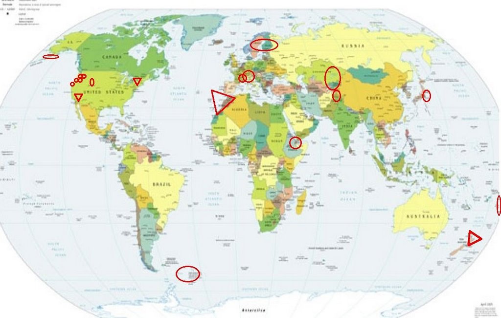
Places to watch.
(I am most concerned for the New Zealand area.
This area regularly has micro to medium quakes
and I rarely feel precursors for them. This time
the symptom was very strong and painful.
Please be prepared.)
Good luck to all.
For Tuesday, 19 December 2006.
--------------------------------------
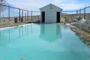
Warm Springs, NV area (38.187N 116.587W)
(This symptom was really strong and woke
me up in the night - Very Strong.)
www.nevadatravel.net
--------------------------------------
1.9 2006/12/20 06:01:12 37.498 -118.181 0.1 22 km ( 14 mi) NW of Deep Springs, CA
1.4 2006/12/20 01:37:24 37.336 -118.539 10.8 9 km ( 5 mi) WSW of West Bishop, CA
1.8 2006/12/19 23:22:45 37.506 -118.202 0.4 23 km ( 14 mi) NE of Bishop, CA
1.1 2006/12/19 17:38:08 37.486 -118.185 7.0 22 km ( 14 mi) NW of Deep Springs, CA
2.7 2006/12/19 15:36:09 37.493 -118.191 5.8 23 km ( 14 mi) NW of Deep Springs, CA
4.0 2006/12/19 15:21:42 37.493 -118.188 9.2 23 km ( 14 mi) NW of Deep Springs, CA
3.4 2006/12/19 15:18:40 37.491 -118.191 10.9 23 km ( 14 mi) NW of Deep Springs, CA
2.8 2006/12/19 15:15:19 37.492 -118.189 12.1 23 km ( 14 mi) NW of Deep Springs, CA
2.5 2006/12/19 15:10:10 37.493 -118.189 12.6 23 km ( 14 mi) NW of Deep Springs, CA
(These may be the quakes for the symptom - probably didn’t place the pain right since it was mostly at night waking me up.)
Sweden (Second symptom but a little different
area and may extend to Finland/Russia - Medium)
--------------------------------------
CENTRAL NORBOTTEN SWEDEN
Origin time Lat Lon Azres Timres Wres Nphase Ntot Nsta Netmag
2006-353:00.16.45.0 68.13 19.20 12.73 0.27 3.45 3 6 2 1.58
CENTRAL NORBOTTEN SWEDEN
Origin time Lat Lon Azres Timres Wres Nphase Ntot Nsta Netmag
2006-353:00.19.37.0 68.08 19.34 7.88 3.46 5.43 6 11 3 1.92
SOUTH-WESTERN NORRBOTTEN SWEDEN
Origin time Lat Lon Azres Timres Wres Nphase Ntot Nsta Netmag
2006-353:04.06.43.0 67.36 18.66 12.80 0.12 3.32 2 4 1 2.10
Switzerland to Central Italy (MEDIUM)
--------------------------------------
2006-12-19 20:10:23.4 45.64N 7.05E 10 ML2.6 NORTHERN ITALY
Greenwater, Washington (Second day symptom -
Strong)
and Mt. Hood area
and Mt. St. Helen’s
--------------------------------------
1.8 2006/12/19 05:12:10 46.200 -122.183 0.0 0 km ( 0 mi) W of Mount St. Helens Volcano, WA
1.9 2006/12/19 19:20:48 48.549 -122.417 0.0 2 km ( 1 mi) SE of Edison, WA
Ethiopia area (11.49N 43.44E)(Second day
symptom - Strong)
--------------------------------------
(Came in on the 18th)
Tonga area
--------------------------------------
2006-12-19 19:58:29.5 20.91S 174.39W 33 mb5.2 TONGA
The Geysers
--------------------------------------
2.7 2006/12/18 19:48:04 38.818 -122.790 0.6 3 km ( 2 mi) NE of The Geysers, CA
1.7 2006/12/18 08:22:05 38.817 -122.790 0.0 3 km ( 2 mi) NE of The Geysers, CA
2.2 2006/12/18 03:17:36 38.794 -122.756 2.5 4 km ( 3 mi) E of The Geysers, CA
2.5 2006/12/18 02:59:46 38.820 -122.791 0.8 3 km ( 2 mi) NNE of The Geysers, CA
1.1 2006/12/19 00:49:40 38.796 -122.753 3.1 5 km ( 3 mi) E of The Geysers, CA
1.9 2006/12/19 07:39:48 38.780 -122.761 0.0 4 km ( 3 mi) ESE of The Geysers, CA
1.7 2006/12/19 08:20:01 38.891 -123.022 2.0 10 km ( 6 mi) N of Cloverdale, CA
1.7 2006/12/19 09:22:16 38.834 -122.799 1.9 4 km ( 3 mi) N of The Geysers, CA
1.1 2006/12/19 17:54:33 38.820 -122.787 4.5 3 km ( 2 mi) NE of The Geysers, CA
1.6 2006/12/19 18:56:47 38.802 -122.740 1.9 4 km ( 2 mi) SSW of Cobb, CA
Strait of Gibraltar to Morocco (Third
day symptom but already at Very Strong)
www.hiptravelguide.com
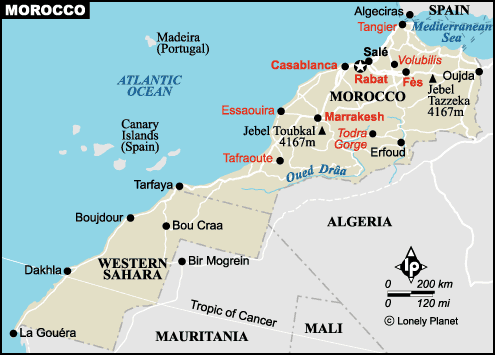
--------------------------------------
2006-12-20 01:12:34.0 36.94N 2.20E mb3.2 NORTHERN ALGERIA
Honshu, Japan area (Second day
symptom - STRONG)
--------------------------------------
2006/12/19,20:44 24.9 N 122.4 E 40 km Mj 4.7 NW_OFF_ISHIGAKIJIMA_IS 82.35
2006/12/19,18:20 38.3 N 143.4 E 30 km Mj 4.3 FAR_E_OFF_MIYAGI_PREF 95.20
2006/12/19,12:56 37.3 N 142.1 E 30 km Mj 3.7 E_OFF_FUKUSHIMA_PREF 86.79
2006/12/19,09:45 36.3 N 137.0 E 280 km Mj 3.9 TOYAMA_GIFU_BORDER_REG 97.56
2006/12/19,09:33 35.3 N 137.2 E 10 km Mj 4.3 CENTRAL_AICHI_PREF 96.33
North Island, N.Z. area (36.99S 179.66W)
(EXTREMELY STRONG - sometimes New Zealand
quakes come in earlier than the posted day.
Be prepared.)
www.rental-car-in-new-zealand.com

--------------------------------------
Reference Number: 2670301/G
Universal Time: December 19 2006 at 1:35
NZ Daylight Time: Tuesday, December 19 2006 at 2:35 pm
Latitude, Longitude: 37.97°S, 176.52°E
Focal Depth: 5 km
Richter Magnitude: 3.0
(Not big - more to come and may take until 25 or 26 December)
HINDU KUSH, AFGHANISTAN, REG
(36.87N 70.63E)
--------------------------------------
2006-12-20 11:36:13.8 37.33N 71.59E 100 mb4.6 TAJIKISTAN
FRANCE (46.19N 2.80E)(STRONG)
--------------------------------------
2006-12-19 02:41:08.0 43.26N 0.84W 10 ML2.5 PYRENEES
2006-12-19 03:17:22.2 48.35N 6.71E 10 ML2.5 FRANCE
2006-12-19 09:14:22.0 44.16N 6.98E 2 ML2.9 FRANCE
2006-12-19 13:17:53.7 43.16N 5.67E 10 ML2.7 NEAR SOUTH COAST OF FRANCE
2006-12-19 20:39:57.8 46.47N 4.27W 10 ML3.8 BAY OF BISCAY
2006-12-20 10:09:28.8 49.36N 0.03E 2 ML3.1 FRANCE
2006-12-20 16:21:45.1 49.45N 0.22W 10 ML3.0 FRANCE
Norfolk, NY area (46.158N 76.016W)
(Very Strong)
www.epodunk.com
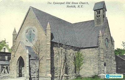
--------------------------------------
Region: NEW YORK
Geographic coordinates: 44.611N, 74.947W
Magnitude: 1.7 Mcd
Depth: 9 km
Universal Time (UTC): 20 Dec 2006 20:50:04
Island Park, Idaho area (44.372 -111.048)
--------------------------------------
1.2 2006/12/20 02:54:19 44.636 -110.140 1.4 45km(28mi)SSW of Cooke City-Silver Gate, MT
Kazakhstan to Kyrgyzstan
--------------------------------------
2006-12-20 11:34:58.0 51.50N 60.49E ML3.1 RUSSIA-KAZAKHSTAN BORDER REGION
Aleutians
--------------------------------------
2.7 2006/12/18 04:41:45 53.073 -166.694 1.0 FOX ISLANDS, ALEUTIAN ISLANDS, ALASKA
2.9 2006/12/18 11:19:55 53.464 -166.910 50.0 FOX ISLANDS, ALEUTIAN ISLANDS, ALASKA
South Sandwich Islands area
--------------------------------------
2006-12-20 13:40:57.0 60.54S 49.52W 144 mb4.8 SCOTIA SEA
Newberg, OR area (45.438N 123.298W)
(Strong)
--------------------------------------
2.8 2006/12/19 03:02:30 45.172 -122.612 19.1 4 km ( 2 mi) NW of Molalla, OR
1.4 2006/12/19 00:56:41 45.885 -122.255 6.2 12 km ( 7 mi) E of Yacolt, WA
1.8 2006/12/19 05:12:03 46.448 -122.126 35.3 17 km ( 11 mi) SE of Morton, WA
Peace to all.

posted by Unknown @ 11:47 AM
0 comments
![]()
![]()
