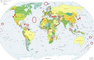
*For Tuesday, 7 November 2006.
LEGEND for OVERVIEW: Size = My surety of area for quake.
Red Circle = Probable quake to STRONG quake.
Triangle = Very Strong/Stronger quake (Usually takes extra days).
Blue Circle, etc. = Uncertainty of symptom area for probable quake.

Places to watch.
Good luck to all.
For Tuesday, 7 November 2006.
--------------------------------------
JAN MAYEN ISLAND REGION (70.92N 6.54W)
(Medium)
--------------------------------------
JAN MAYEN REGION
Origin time Lat Lon Azres Timres Wres Nphase Ntot Nsta Netmag
2006-310:10.54.19.0 70.39 -7.06 16.48 0.21 4.33 3 8 2 1.94
Parkfield Fault/Central to North (medium)
--------------------------------------
1.5 2006/11/07 11:47:46 36.770 -120.869 5.8 29 km ( 18 mi) SW of South Dos Palos, CA
1.3 2006/11/07 15:35:37 35.925 -120.477 5.3 5 km ( 3 mi) NW of Parkfield, CA
2.6 2006/11/07 19:08:49 36.033 -120.080 8.0 4 km ( 2 mi) ENE of Avenal, CA
1.2 2006/11/07 22:02:59 36.509 -121.093 5.2 5 km ( 3 mi) ESE of Pinnacles, CA
1.1 2006/11/07 22:16:22 36.628 -121.250 9.3 14 km ( 9 mi) NW of Pinnacles, CA
Alaska Peninsula
--------------------------------------
3.8 2006/11/06 19:17:42 54.331 -162.000 15.0 ALASKA PENINSULA
3.3 2006/11/06 16:12:34 58.051 -157.100 5.0 ALASKA PENINSULA
Northern Mid Atlantic Ridge area (33.0N 38.6W)
(May be 2 different areas.)
--------------------------------------
(Nothing found)
Hawaii (2 different symptoms - Strong)
--------------------------------------
3.2 2006/11/06 20:38:50 19.988 -155.574 14.3 11 km ( 7 mi) ESE of Waimea, HI
2.4 2006/11/07 07:53:44 19.337 -155.187 6.7 14 km ( 8 mi) SSE of Volcano, HI
Puerto Rico/Virgin Islands
--------------------------------------
06/11/07 22:31:40 12.94N 88.98W 15.0 3.7ML Frente a El Salvador
06/11/07 06:23:04 10.84N 82.93W 66.6 3.6ML Sismo regional o lejano
06/11/07 05:38:22 11.18N 87.34W 3.1 3.7ML Frente a Masachapa
06/11/07 00:57:46 11.41N 87.32W 72.5 2.6ML Frente a Puerto Sandino
06/11/07 00:36:49 11.66N 85.77W 6.3 2.8ML Cerca de Isla de Zapatera
Northcentral Iran (Second day symptom - Strong)
--------------------------------------
2006-11-07 08:52:21.0 31.93N 49.17E 18 ML4.0 WESTERN IRAN
Halmahera, Indonesia area (1.29N 128.23E)
(STRONG)
--------------------------------------
06Nov2006 01:01:01.8 4.9S 144.4E 33 mb=4.8 M*GSR NEAR N COAST OF NEW GUINEA
06Nov2006 19:24:12.6 6.4S 151.3E 70 mb=5.1 M*GSR NEW BRITAIN REGION, P.N.G.
06Nov2006 20:56:49.5 5.4S 146.6E112 M =5.8 M*NEI EASTERN NEW GUINEA REG., P
07Nov2006 09:16:01.8 5.8S 151.0E 70 mb=4.9 M*GSR NEW BRITAIN REGION, P.N.G.
Northern Sumatra (4.85N 95.14E) (STRONG)
--------------------------------------
(Nothing found)
Canby, Oregon area (45.304 -122.362)/
Mt. Hood area
(2 diferent symptoms - STRONG)
--------------------------------------
2.6 2006/11/06 05:34:35 45.516 -122.648 15.7 1 km ( 1 mi) SW of Portland, OR
1.7 2006/11/07 09:56:19 45.518 -122.681 17.4 3 km ( 2 mi) W of Portland, OR
1.9 2006/11/07 09:53:36 45.514 -122.674 16.7 3 km ( 2 mi) WSW of Portland, OR
San Francisco
--------------------------------------
2.0 2006/11/06 16:41:24 37.882 -122.248 10.5 3 km ( 2 mi) ENE of Berkeley, CA
1.3 2006/11/07 00:18:09 37.776 -121.943 5.6 2 km ( 1 mi) NNE of San Ramon, CA
WESTERN ARABIAN PENINSULA (12.27N
44.63E)
(Medium)
--------------------------------------
2006-11-08 04:32:10.4 28.28N 31.84E 30f Mw4.5 EGYPT
(Coordinates way off if right quake.)
Mt. St. Helen’s
--------------------------------------
1.2 2006/11/07 14:11:01 46.195 -122.193 0.1 1 km ( 1 mi) WSW of Mount St. Helens Volcano, WA
Haiti/possibly tip of Cuba
--------------------------------------
4.5 2006/11/07 14:11:25 19.649 -70.465 10.0 24 km ( 15 mi) NE of Tamboril, Dominican Republic
2.8 2006/11/08 19:30:20 18.955 -67.902 24.7 93 km ( 58 mi) ENE of Higüey, Dominican Republic
3.3 2006/11/09 00:11:32 19.088 -67.897 4.1 100 km ( 62 mi) ENE of Higüey, Dominican Republic
3.5 2006/11/09 11:33:44 18.606 -68.596 152.2 12 km ( 8 mi) E of Higüey, Dominican Republic
(2 extra days)
Honshu, Japan (STRONG)
then Ryukyu area (medium)
--------------------------------------
(Nothing found)
Clatskanie, OR area (46.101N 123.277W)
(May go along with Mt. Hood area - still
working out Pacific Northwest symptoms.)
--------------------------------------
(Nothing found)
Turkey
--------------------------------------
2006-11-07 10:16:25.1 38.61N 43.34E 24 MD3.0 EASTERN TURKEY
Kermadec Islands
--------------------------------------
(Nothing found - could go along with the Vanuatu symptom which was actually south of Fiji.)
Vanuatau (Second day symptom - STRONG)
--------------------------------------
07Nov2006 06:23:35.6 23.5S 179.6W490 mb=5.4 M*GSR SOUTH OF FIJI ISLANDS
East Carbon, UT area (39.668 -110.524)
(MEDIUM)
--------------------------------------
06/11/06 13:33:25 39.73N 110.80W 0.0 1.3 4.6 mi NNE of Helper
06/11/06 14:41:01 39.68N 112.11W 5.1 1.7 14.7 mi WSW of Nephi
06/11/06 20:35:25 38.95N 112.95W 6.9 1.4 29.5 mi W of Kanosh
06/11/06 23:36:05 39.41N 111.22W 2.5 1.8 15.0 mi WNW of Huntington
06/11/06 23:46:53 39.67N 110.47W 4.6 1.4 9.3 mi NNW of E. Carbon City
06/11/07 02:25:40 39.67N 110.47W 4.6 1.6 9.0 mi NNW of E. Carbon City
06/11/07 03:02:50 39.41N 111.23W 2.5 1.6 15.1 mi E of Spring City
06/11/07 04:20:07 39.71N 110.61W 1.7 1.5 13.3 mi NE of Price
06/11/07 09:03:25 37.80N 113.12W 2.7 1.1 5.8 mi W of Enoch
06/11/07 13:35:42 39.67N 110.48W 2.3 1.3 9.2 mi NW of E. Carbon City
Peace to all.

