*For Tuesday, 7 March 2006.
LEGEND for OVERVIEW:
Size = My surety of area for quake.
Red Circle = Probable quake to STRONG quake.
Triangle = Very Strong or Stronger quake (And usually takes extra days).
Blue Circle, etc. = Uncertainty of symptom area for probable quake.
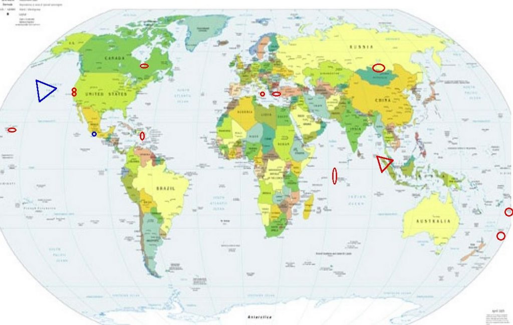
Places to watch.
Good luck to all.
For Tuesday, 7 March 2006.
----------------------------------------
Carlsberg Ridge (2.76S 68.07E) (Volcanic)
----------------------------------------
MAP 6.4 2006/03/06 18:13:09 -40.131 78.473 10.0 MID-INDIAN RIDGE
2006-03-07 07:10:52.1 40.21S 78.42E 33f mb 5.3 MID-INDIAN RIDGE
Possibly Mexico City area
----------------------------------------
2006/03/06 11:01:42 17.45 100.89 31 4.2 GUERRERO
2006/03/06 15:37:28 16.68 99.24 16 4.4 COSTA DE GUERRERO
2006/03/06 16:03:50 16.87 100.48 5 3.7 COSTA DE GUERRERO
The Geysers (strong)
----------------------------------------
MAP 1.7 2006/03/06 07:32:18 38.821 -122.776 1.6 4 km ( 2 mi) NE of The Geysers, CA
MAP 2.6 2006/03/06 20:42:29 38.821 -122.835 1.2 4 km ( 2 mi) NW of The Geysers, CA
MAP 1.8 2006/03/07 01:59:15 38.786 -122.751 0.0 5 km ( 3 mi) ESE of The Geysers, CA
MAP 2.8 2006/03/07 04:36:35 38.814 -122.815 2.5 2 km ( 1 mi) NNW of The Geysers, CA
Northern Sumatra (3 different symptoms and some strong ones - VERY STRONG)
http://www.asiatravelling.net/indonesia/sumatra/sumatra_culture.htm>asiatravelling

----------------------------------------
2006-03-07 04:53:30.7 3.46N 128.09E 131 mb5.3 NORTH OF HALMAHERA, INDONESIA
2006-03-08 06:33:37 5.6 3.99 N 96.17 E Northern Sumatra, Indonesia
2006-03-08 10:59:55 5.1 1.46 N 97.34 E Northern Sumatra, Indonesia
2006-03-08 14:49:52 4.9 14.08 N 94.10 E Andaman Islands, India Region
(Quite a few more Andaman Islands quakes occurred on the 9th but posting them there. The symptoms I had for them are for the 7th - they took only 2 extra days and Very Strong symptoms usually take longer. I am wondering if that may be changing.)
Puerto Rico (strong)
----------------------------------------
MAP 3.6 2006/03/06 23:07:58 19.047 -63.795 5.0 65 km ( 41 mi) ENE of Settlement, British Virgin Islands
MAP 3.1 2006/03/06 22:22:48 18.901 -67.525 17.4 65 km ( 40 mi) NW of Aguadilla, PR
MAP 2.5 2006/03/06 21:17:26 18.034 -67.439 14.9 27 km ( 17 mi) W of Puerto Real, PR
MAP 3.6 2006/03/06 19:08:23 19.160 -63.786 24.7 74 km ( 46 mi) NE of Settlement, British Virgin Islands
MAP 2.7 2006/03/06 18:18:25 18.848 -63.803 15.0 56 km ( 35 mi) ENE of Settlement, British Virgin Islands
MAP 3.6 2006/03/06 18:17:00 19.118 -63.988 5.0 56 km ( 35 mi) NE of Settlement, British Virgin Islands
MAP 2.4 2006/03/06 13:36:01 17.820 -66.695 5.0 19 km ( 12 mi) S of Tallaboa, PR
MAP 2.5 2006/03/06 02:02:16 18.924 -63.829 27.9 56 km ( 35 mi) ENE of Settlement, British Virgin Islands
MAP 3.4 2006/03/06 01:59:30 19.109 -63.924 5.0 59 km ( 37 mi) NE of Settlement, British Virgin Islands
MAP 3.1 2006/03/06 01:47:13 18.773 -63.753 47.9 60 km ( 37 mi) E of Settlement, British Virgin Islands
MAP 3.2 2006/03/07 20:23:40 19.425 -65.388 9.1 121 km ( 75 mi) NNE of Vieques, PR
MAP 2.7 2006/03/07 20:08:16 19.215 -64.153 5.0 57 km ( 35 mi) NNE of Settlement, British Virgin Islands
MAP 3.0 2006/03/07 20:05:08 19.038 -66.545 65.9 64 km ( 40 mi) N of Tierras Nuevas Poniente, PR
MAP 2.9 2006/03/07 20:02:49 19.134 -66.600 21.3 75 km ( 47 mi) NNE of Carrizales, PR
MAP 2.1 2006/03/07 12:37:25 17.880 -67.004 15.8 11 km ( 7 mi) SSE of La Parguera, PR
MAP 3.4 2006/03/07 07:39:48 19.118 -63.884 5.0 63 km ( 39 mi) NE of Settlement, British Virgin Islands
MAP 3.2 2006/03/07 07:08:24 19.105 -63.837 5.0 66 km ( 41 mi) NE of Settlement, British Virgin Islands
MAP 3.5 2006/03/07 07:01:50 18.282 -67.925 115.7 71 km ( 44 mi) W of Rincón, PR
MAP 3.3 2006/03/07 05:02:02 18.943 -63.861 3.6 54 km ( 33 mi) ENE of Settlement, British Virgin Islands
MAP 2.6 2006/03/07 00:19:57 19.128 -63.897 5.0 63 km ( 39 mi) NE of Settlement, British Virgin Islands
MAP 3.1 2006/03/08 17:06:06 17.968 -66.970 7.9 5 km ( 3 mi) W of Guánica, PR
MAP 2.7 2006/03/08 10:46:41 18.450 -67.353 2.8 16 km ( 10 mi) NW of Rincón, PR
MAP 3.2 2006/03/08 02:42:04 18.980 -65.043 23.7 70 km ( 44 mi) NNW of Little Harbour, British Virgin Islands
MAP 2.5 2006/03/08 00:41:51 18.498 -65.120 28.2 26 km ( 16 mi) NW of CHARLOTTE AMALIE, US Virgin Islands
MAP 2.6 2006/03/08 00:37:46 18.493 -65.116 26.7 25 km ( 16 mi) NW of CHARLOTTE AMALIE, US Virgin Islands
Tonga area
----------------------------------------
(Nothing found - symptom may go along with Kermadec/Fiji)
Kermadec Islands (27.4S 178.8W) (STRONG)
----------------------------------------
2006-03-06 16:05:45.4 18.18S 178.39W 554 M4.5 FIJI ISLANDS REGION
Lake Baykal, Russia area (55.23N 110.31E)
----------------------------------------
2006-03-07 10:08:34.0 51.21N 60.42E ML3.0 URAL MOUNTAINS, RUSSIA, REGION
Sicily, Italy
----------------------------------------
(Nothing found)
Hawaii (strong)
----------------------------------------
MAP 1.8 2006/03/07 02:17:40 19.432 -155.318 4.1 9 km ( 6 mi) WSW of Volcano, HI
MAP 1.8 2006/03/07 03:38:03 19.436 -155.320 3.9 9 km ( 6 mi) W of Volcano, HI
MAP 1.9 2006/03/07 03:38:24 19.504 -155.218 4.1 6 km ( 4 mi) NNE of Volcano, HI
MAP 1.8 2006/03/07 06:25:29 19.386 -155.284 2.7 9 km ( 5 mi) SW of Volcano, HI
MAP 1.9 2006/03/07 13:48:45 19.383 -155.286 2.2 9 km ( 6 mi) SW of Volcano, HI
MAP 2.4 2006/03/07 21:16:30 19.393 -155.280 3.1 8 km ( 5 mi) SW of Volcano, HI
Lake Nacimiento (35.738 -121.017)
----------------------------------------
MAP 2.1 2006/03/08 18:53:42 35.663 -121.091 0.5 9 km ( 6 mi) ENE of San Simeon, CA
Possibly Axial Seamount in Juan de Fuca Ridge (Not sure of location but this is a logical guess - Very Strong. This might be in the 150W 40N area.)
http://www.flickr.com/photos/princeofwhales>princeofwhales
----------------------------------------
2006-03-09 08:23:51 5.4 44.93 N 151.78 E East of Kuril Islands
Aegean Sea
----------------------------------------
2006-03-06 23:20:51.6 35.32N 27.37E 80 ML3.5 DODECANESE ISLANDS, GREECE
2006-03-06 21:37:01.5 38.57N 26.83E 5 MD3.4 AEGEAN SEA
2006-03-07 16:17:54.0 35.34N 27.17E 66 ML3.5 DODECANESE ISLANDS, GREECE
James Bay, Canada area (53.51N 81.86W)
----------------------------------------
(Came in on the 8th and posted there.)
Peace to all.

posted by Unknown @ 1:31 PM
0 comments
![]()
![]()
