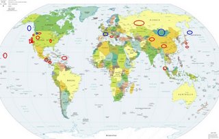
*For Wednesday, 4 October 2006.
LEGEND for OVERVIEW: Size = My surety of area for quake.
Red Circle = Probable quake to STRONG quake.
Triangle = Very Strong/Stronger quake (Usually takes extra days).
Blue Circle, etc. = Uncertainty of symptom area for probable quake.

Places to watch.
Good luck to all.
For Wednesday, 4 October 2006.
---------------------------------------
Possibly Kuril Islands (44.63N 147.66E)
(Unproven symptom - STRONG)
---------------------------------------
2006-10-04 07:40:55.7 46.61N 153.54E 20 mb5.3 KURIL ISLANDS, RUSSIA
2006-10-04 19:44:17.8 46.84N 153.10E 2 Ms4.3 KURIL ISLANDS, RUSSIA
Puerto Rico/Virgin Islands
---------------------------------------
3.1 2006/10/04 19:13:52 18.710N -65.061W 9.4 42 km (26 mi) NNW of Charlotte Amalie, Saint Thomas, US Virgin Islands
3.0 2006/10/04 07:04:17 19.521N -67.215W 3.9 115 km (71 mi) N of San Antonio, PR
2.8 2006/10/04 02:47:02 18.459N -64.954W 4.8 12 km ( 8 mi) N of Charlotte Amalie, Saint Thomas, US Virgin Islands
Ural Mountains Region, Russia
(57.21N 61.30E)
---------------------------------------
2006-10-06 00:09:58.0 55.40N 61.98E ML3.6 URAL MOUNTAINS, RUSSIA, REGION
(2 extra days)
XINJIANG, CHINA area (38.47N 80.57E)
---------------------------------------
2006-10-06 01:00:56.0 41.69N 81.61E ML4.0 SOUTHERN XINJIANG, CHINA
(2 extra days)
San Francisco areas:
Moraga, California (37.816 -122.070)
and then
Milpitas, California (37.490 -121.844)
(Indication of depth for Milpitas area - STRONG)
and then
Santa Cruz, California area (36.84 -122.33)
and then
Boulder Creek, California (37.13 -122.12)
(As usual - keep in mind I get California symptoms
larger than life...but for the Boulder Creek area I had
sympoms that were - Very Strong.)
damer.com

---------------------------------------
1.2 2006/10/02 02:15:06 37.463 -121.826 5.6 7 km ( 4 mi) ENE of Milpitas, CA
1.4 2006/10/02 04:28:41 37.164 -122.071 12.0 6 km ( 4 mi) NE of Boulder Creek, CA
1.6 2006/10/04 00:10:39 37.455 -121.796 9.0 9 km ( 6 mi) ENE of Milpitas, CA
1.1 2006/10/04 09:45:45 37.925 -122.143 13.0 5 km ( 3 mi) NW of Lafayette, CA
1.5 2006/10/04 14:13:39 37.765 -122.197 14.1 4 km ( 3 mi) SE of Oakland, CA
2.3Q 2006/10/04 19:59:48 36.898 -121.629 0.0 1 km ( 1 mi) S of Quarry near Logan (Watsonville), CA(Probable quarry explosion)
QINGHAI, CHINA (33.11N 95.83E)
---------------------------------------
(Nothing found)
Guatamala/El Salvador area
and then
Nicaragua/Costa Rica area
---------------------------------------
06/10/04 07:03:35 15.55N 88.45W 1.0 3.8ML Sismo regional o lejano
06/10/04 04:03:27 13.06N 89.48W 1.0 3.9ML Frente a El Salvador
Central Italy
---------------------------------------
2006-10-04 04:57:24.0 42.95N 12.75E 5 ML2.3 CENTRAL ITALY
2006-10-04 17:34:18.8 42.10N 15.66E 92 ML4.6 ADRIATIC SEA
The New Madrid Fault/Hayti, MO area
(36.270N 89.770W)
---------------------------------------
1.6 2006/10/04 10:43:39 36.530 -89.520 7.7 7 km ( 4 mi) SSE of New Madrid, MO
Hawaii (medium)
---------------------------------------
2.3 2006/10/04 09:38:19 19.381 -155.288 2.2 9 km ( 6 mi) SW of Volcano, HI
Canby, Oregon area (45.304 -122.362)
---------------------------------------
1.5 2006/10/04 21:26:02 44.172 -121.890 10.8 30 km ( 19 mi) WSW of Sisters, OR
Montana
---------------------------------------
1.1 2006/10/03 00:45:05 44.762 -110.948 4.1 17 km(10 mi) NE of West Yellowstone, MT
1.4 2006/10/03 03:32:02 44.459 -110.761 2.0 35 km(22 mi) SE of West Yellowstone, MT
1.5 2006/10/03 06:55:39 44.587 -110.971 4.8 14 km(8 mi) SE of West Yellowstone, MT
1.2 2006/10/03 08:03:10 44.760 -110.946 3.7 17 km(10 mi) NE of West Yellowstone,MT
1.9 2006/10/04 00:34:56 45.013 -111.748 0.0 35 km(22 mi) SSE of Virginia City, MT
Sumatra
---------------------------------------
2006-10-04 13:33:39.1 1.15N 97.54E 60 mb5.0 NORTHERN SUMATERA, INDONESIA
Possibly Mt. Adams area (If it is not right
at the symptom area for Mt. St. Helen’s,
I am still not sure enough to post a pinpoint area.)
---------------------------------------
1.5 2006/10/04 21:26:02 44.172 -121.890 10.8 30 km ( 19 mi) WSW of Sisters, OR
(Also posted on the 3d and above - many areas in the Pacific Northwest are still causing symptoms and I am not proficient yet at separating them.)
Honshu, Japan
then
IZU ISLANDS, JAPAN REGION (31.225 141.844)
---------------------------------------
2006-10-04 00:37:19.6 33.29N 146.14E 2 mb5.2 OFF EAST COAST OF HONSHU, JAPAN
Possibly France (Unproven symptom)
---------------------------------------
2006-10-03 10:18:22.6 49.43N 0.24W 10 ML3.2 FRANCE
Wyoming/Utah
---------------------------------------
1.2 2006/10/04 00:09:00 39.418 -111.225 2.4 24 km ( 15 mi) ESE of Spring City, UT
2.3 2006/10/04 02:04:01 37.275 -110.621 0.6 21 km(13 mi) SSE of Halls Crossing, UT
1.5 2006/10/04 05:59:55 39.412 -111.232 7.2 24 km ( 15 mi) ESE of Spring City, UT
1.6 2006/10/04 18:21:14 40.725 -112.257 2.2 10 km ( 6 mi) NNE of Stansbury Park, UT
1.8 2006/10/04 18:41:05 39.413 -111.224 6.5 24 km ( 15 mi) WNW of Huntington, UT
1.6 2006/10/04 22:20:15 39.417 -111.225 1.8 24 km ( 15 mi) ESE of Spring City, UT
San Simeon/Lake Nacimiento area
---------------------------------------
1.9 2006/10/05 19:37:09 35.725 -121.099 7.1 12 km ( 8 mi) NE of San Simeon, CA
Possibly Mongolia area or GULF OF ALASKA area
(58.588 -148.273)
(Symptoms are almost over-lapping.)
---------------------------------------
(Nothing found)
Peace to all.

