*For Wednesday, 28 June 2006.
LEGEND for OVERVIEW: Size = My surety of area for quake.
Red Circle = Probable quake to STRONG quake.
Triangle = Very Strong/Stronger quake (Usually takes extra days).
Blue Circle, etc. = Uncertainty of symptom area for probable quake.
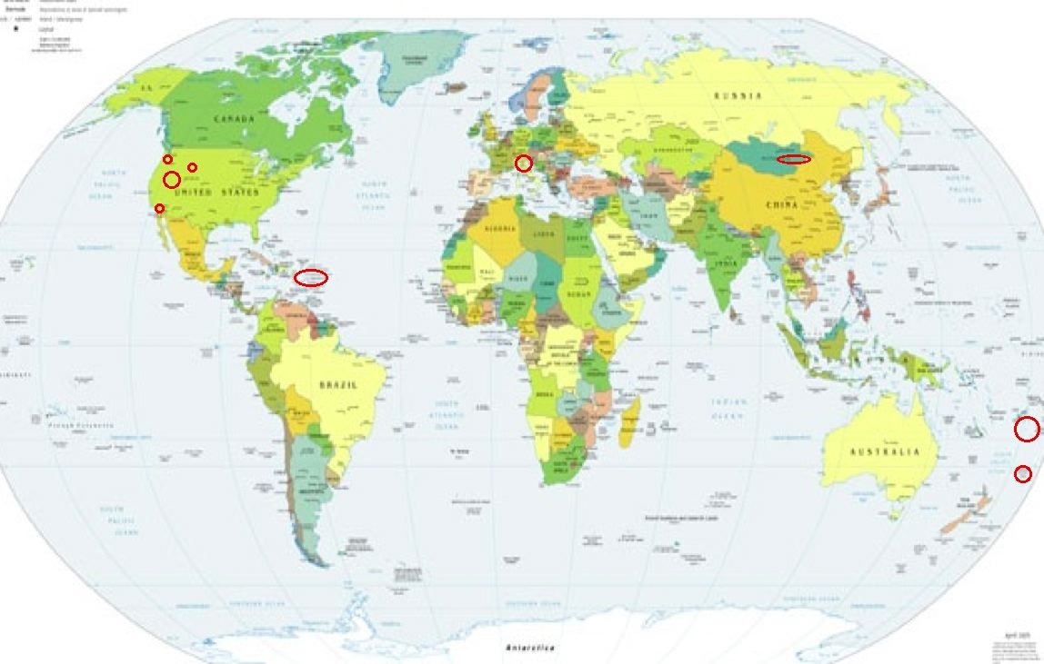
Places to watch.
Good luck to all.
For Wednesday, 28 June 2006.
----------------------------------------
Utah/Nevada
----------------------------------------
1.4 2006/06/28 03:17:29 39.733 -110.744 0.8 11 km ( 7 mi) ENE of Helper, UT
2.0 2006/06/28 04:00:21 38.038 -112.809 2.3 17 km ( 11 mi) N of Paragonah, UT
1.6 2006/06/28 16:06:15 39.606 -110.401 0.8 6 km ( 4 mi) N of Sunnyside, UT
2.2 2006/06/28 22:25:45 40.435 -117.291 15.0 14 km ( 9 mi) NNW of McCoy, NV
Mt. St. Helen’s
----------------------------------------
1.6 2006/06/28 02:55:00 46.194 -122.196 0.7 1 km(1 mi) WSW of Mount St. Helens Volcano, WA
2.4 2006/06/28 03:12:33 46.188 -122.183 0.0 1 km(1 mi) S of Mount St. Helens Volcano, WA
1.5 2006/06/28 09:12:56 46.194 -122.197 0.0 1 km(1 mi) WSW of Mount St. Helens Volcano, WA
1.3 2006/06/28 14:38:53 46.196 -122.195 0.6 1 km(1 mi) WSW of Mount St. Helens Volcano, WA
Puerto Rico/Virgin Islands
----------------------------------------
3.1 2006/06/28 00:21:54 19.095 -67.876 10.3 102 km(64 mi) ENE of Higüey, Dominican Republic
2.9 2006/06/28 02:01:13 18.621 -66.119 89.1 20 km(13 mi) N of Cataño, PR
2.6 2006/06/28 03:13:33 17.871 -65.766 5.8 19 km(12 mi) SE of Emajagua, PR
3.0 2006/06/28 11:28:38 19.081 -67.891 12.7 100 km(62 mi) ENE of Higüey, Dominican Republic
3.5 2006/06/28 22:12:58 18.655 -65.149 25.2 41 km(25 mi) NW of CHARLOTTE AMALIE, US Virgin Islands
3.5 2006/06/29 18:27:37 18.651N -65.157W 25.4 41 km(25 mi) NW of Charlotte Amalie, Saint Thomas, US Virgin Islands
3.9 2006/06/29 05:12:28 18.207N -67.433W 10.0 23 km(15 mi) WSW of Stella, PR
Tonga/Fiji area
----------------------------------------
2006-06-27 02:59:13.9 19.79S 178.25W 556 mb6.0 FIJI ISLANDS REGION
2006-06-27 14:03:53.9 17.69S 177.36W 33 mb5.4 FIJI ISLANDS REGION
2006-06-27 19:11:48.3 20.87S 178.71W 33 mb5.6 FIJI ISLANDS REGION
2006-06-28 02:36:31.4 14.93S 177.92W 33 mb5.4 FIJI ISLANDS REGION
NW of Ennis, MT (45.493 -111.889)
(Medium)
----------------------------------------
1.2 2006/06/28 15:11:27 45.596 -111.921 1.4 16 km ( 10 mi) SW of Harrison, MT
1.6 2006/06/28 21:51:17 46.004 -111.561 1.2 12 km ( 8 mi) N of Three Forks, MT
Central to Northern Italy
(Medium)
----------------------------------------
(Nothing found)
Big Bear City, California
(34.345N 116.850W)
----------------------------------------
1.4 2006/06/28 06:43:39 33.638 -116.672 20.1 9 km(6 mi) N of Anza, CA
Kermadec Islands area
----------------------------------------
2006-06-27 19:11:48.3 20.57S 178.31W 33 mb5.7 FIJI ISLANDS REGION
Mongolia area (48.83 N 110.88)
(Probably residual symptom from
extreme ones the day before but
indication of depth this time.)
----------------------------------------
(Posting them on the 27th because the symptoms were strongest for that day.)
Peace to all.

posted by Unknown @ 12:39 PM
0 comments
![]()
![]()
