*For Friday, 10 February 2006.
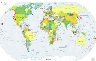
LEGEND for OVERVIEW:
Size = My surety of area for quake.
Red Circle = Probable quake to STRONG quake.
Triangle = Very Strong or Stronger quake (And usually takes extra days).
Blue Circle, etc. = Uncertainty of symptom area for probable quake.

Places to watch.
Good luck to all.
For Friday, 10 February 2006.
----------------------------------------
The New Madrid Fault/Missouri (36.560 -89.600) (Strong - possibly a swarm of quakes.)
----------------------------------------
MAP 2.1 2006/02/10 08:59:48 36.660 -89.750 3.6 7 km ( 4 mi) NW of Catron, MO
MAP 5.2 2006/02/10 04:14:17 27.589 -90.204 5.0 183 km (114 mi) S of Grand Isle, LA??
Vancouver Island, Canada (49.777 -127.379) (This may come in on the 8th - it was 2 days early last time. Should be less than a 4 in magnitude because the symptom seemed a little less strong.)
----------------------------------------
(Nothing found - Canada has not updated to the 10th as of this posting.)
Islamabad, Pakistan (Medium)
----------------------------------------
2006-02-11 05:32:54.9 34.50N 73.69E 40 mb4.9 PAKISTAN
Mongolia (Strong)
----------------------------------------
2006-02-10 11:52:56.0 41.86N 81.63E ML3.3 SOUTHERN XINJIANG, CHINA
(Not where it was expected.)
Southern Sumatra area (Medium)
----------------------------------------
2006-02-13 10:46:01.5 5.93S 104.85E 10 mb5.2 SOUTHERN SUMATERA, INDONESIA
(3 extra days)
Sea of Japan area (37.09N 135.70E) (Strong)
----------------------------------------
2006/02/11,00:32 43.6 N 147.3 E 30 km Mj 3.9 E_OFF_HOKKAIDO 58.73
(I think this is the area - further East than expected.)
Ecuador/Colombia area
----------------------------------------
(Nothing found)
Jordan/Syria area (35.58 N 39.56 E)
----------------------------------------
(Nothing found)
South of Eastern Kurils to Rat Islands, Aleutians
----------------------------------------
MAP 3.0 2006/02/10 03:27:20 51.099 -179.478 1.0 ANDREANOF ISLANDS, ALEUTIAN IS., ALASKA
MAP 2.8 2006/02/10 19:40:36 51.000 -178.841 20.0 ANDREANOF ISLANDS, ALEUTIAN IS., ALASKA
Possibly Arizona/California border area (New symptom)
----------------------------------------
MAP 3.8 2006/02/10 21:48:13 39.546 -107.433 5.0 9 km ( 6 mi) W of Glenwood Springs, CO??
Italy (Various areas)
----------------------------------------
2006-02-10 03:10:26.6 45.12N 7.45E 10 ML 2.5 NORTHERN ITALY
2006-02-10 09:14:30.0 38.63N 15.12E 353 ML 3.7 SICILY, ITALY
Paso Robles to Lake Nacimiento, California (35.643 -120.832) (Medium for Lake Nacimiento area)
----------------------------------------
(Nothing found)
Southeastern Alaska (59.608 -137.537) then Southern Alaska
----------------------------------------
MAP 2.7 2006/02/10 01:33:39 61.460 -146.651 20.0 SOUTHERN ALASKA
MAP 3.6 2006/02/10 22:45:29 59.845 -153.779 160.0 SOUTHERN ALASKA
Poland
----------------------------------------
2006-02-10 02:28:36.6 51.59N 16.29E 10 ML 2.7 POLAND
2006-02-10 07:33:02.9 51.47N 16.34E 10 ML 2.7 POLAND
2006-02-10 14:01:02.0 50.94N 16.01E ML 2.5 POLAND
2006-02-10 16:58:34.3 51.51N 15.96E 4 ML 2.8 POLAND
2006-02-10 20:36:14.2 51.42N 16.34E 10 ML 2.0 POLAND
2006-02-11 14:04:55.0 51.53N 16.18E ML 2.2 POLAND
Puerto Rico
----------------------------------------
MAP 3.3 2006/02/10 00:47:12 19.311 -67.424 25.1 100 km ( 62 mi) NNW of Isabela, PR
MAP 3.5 2006/02/10 02:38:32 19.285 -68.188 50.8 92 km ( 57 mi) NE of Higüey, Dominican Republic
MAP 3.3 2006/02/10 09:43:36 19.414 -67.342 35.1 107 km ( 66 mi) NNW of Isabela, PR
Eureka/Petrolia, California area
----------------------------------------
(This symptom goes with the Dunsmuir, California (41.176 -122.255) post below.)
Possibly Maine to Newfoundland area (Left ear tone - usually Atlantic - but this time extremely loud. I figure it means it will be closer to me here in Ohio!)
----------------------------------------
MAP 2.6 2006/02/10 13:30:40 41.750 -81.410 5.0 6 km ( 3 mi) NW of Mentor-on-the-Lake, OH???
(This was close - will listen for another really loud tone to prove it.)
Strait of Gibraltar
----------------------------------------
2006-02-11 22:49:08.2 36.62 N 12.20 W 40 f ML 2.5 NORTH ATLANTIC OCEAN
Hawaii (Medium)
----------------------------------------
MAP 1.8 2006/02/10 05:55:01 19.385 -155.245 2.8 7 km ( 5 mi) S of Volcano, HI
MAP 1.8 2006/02/10 13:30:17 19.381 -155.246 3.0 8 km ( 5 mi) S of Volcano, HI
MAP 2.6 2006/02/10 15:24:09 19.394 -155.251 3.3 6 km ( 4 mi) SSW of Volcano, HI
MAP 2.2 2006/02/10 15:26:36 19.375 -155.239 3.3 8 km ( 5 mi) S of Volcano, HI
MAP 2.1 2006/02/10 22:11:16 19.376 -155.236 3.3 8 km ( 5 mi) S of Volcano, HI
MAP 2.4 2006/02/10 23:51:50 19.387 -155.249 3.3 7 km ( 4 mi) SSW of Volcano, HI
Tonga area (15.78 S 173.98 W)
----------------------------------------
(Nothing found)
Mammoth Lakes area (Medium)
----------------------------------------
MAP 1.1 2006/02/10 01:22:53 37.638 -118.867 4.5 10 km ( 6 mi) E of Mammoth Lakes, CA
MAP 1.3 2006/02/10 18:58:58 37.538 -118.819 9.5 13 km ( 8 mi) WSW of Toms Place, CA
MAP 1.6 2006/02/10 20:08:09 37.420 -118.865 4.8 23 km ( 14 mi) SW of Toms Place, CA
MAP 1.2 2006/02/11 22:09:49 37.627 -118.825 0.7 14 km ( 8 mi) E of Mammoth Lakes, CA
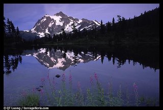
Possibly Mt. Baker or Glacier Peak (Volcanic) then possibly Mt. Rainier and then Mt. St. Helen's (This symptom began at 7:45pm and continued for 6 hours off and on. I will be posting it for 11 February - I know I missed some symtoms because of sleep but it lasted long enough for me to catagorize this as VERY STRONG. I believe it may start with a volcanic eruption but will most likely be a swarm of small to moderate quakes up and down the Cascade line from Mt. St. Helen's to Mt. Baker.)
http://www.terragalleria.com/parks/np.north-cascades.html>Terragalleria

----------------------------------------
MAP 2.7 2006/02/10 13:58:23 46.203 -122.188 0.0 MOUNT ST. HELENS AREA, WASHINGTON
(Nothing VERY STRONG)
Dunsmuir, California (41.176 -122.255)
----------------------------------------
MAP 2.7 2006/02/09 17:49:03 40.287 -122.755 11.3 42 km ( 26 mi) WSW of Cottonwood, CA
MAP 2.5 2006/02/10 10:47:36 40.383 -122.197 7.2 7 km ( 4 mi) E of Cottonwood, CA
Iceland area
----------------------------------------
2006-02-10 18:00:33.2 66.88N 18.30W 17 ML 4.2 ICELAND REGION
Peace to all.

