*For Monday, 13 November 2006.
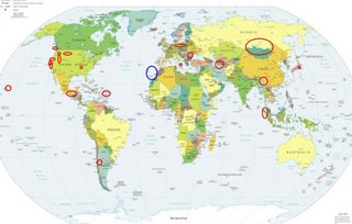
LEGEND for OVERVIEW: Size = My surety of area for quake.
Red Circle = Probable quake to STRONG quake.
Triangle = Very Strong/Stronger quake (Usually takes extra days).
Blue Circle, etc. = Uncertainty of symptom area for probable quake.

Places to watch.
Good luck to all.
For Monday, 13 November 2006.
--------------------------------------
Poland/Germany
(Second day symptom - STRONG)
--------------------------------------
14Nov2006 03:12:01.3 48.4N 9.1E 14 ML=1.6 M LED GERMANY
Utah/Nevada
(2 different symptoms - Strong)
--------------------------------------
1.4 2006/11/13 01:10:30 37.676 -115.104 0.0 14 km ( 9 mi) NE of Hiko, NV
1.7 2006/11/13 06:16:49 37.969 -118.548 11.4 38 km ( 23 mi) S of Qualeys Camp, NV
1.9 2006/11/13 11:33:16 36.046 -115.255 0.0 5 km ( 3 mi) WNW of Enterprise, NV
1.4 2006/11/13 17:49:10 38.859 -118.910 7.2 14 km ( 9 mi) SSW of Schurz, NV
06/11/13 02:44:55 39.68N 110.47W 7.1 1.3 9.6 mi NNW of E. Carbon City
06/11/13 03:29:19 39.42N 111.23W 4.8 1.6 15.1 mi E of Spring City
06/11/13 07:56:26 37.26N 113.98W 7.3 2.9 19.9 mi WNW of Santa Clara
06/11/13 09:18:21 41.77N 112.68W 8.8 1.2 26.8 mi W of Garland
06/11/13 15:44:59 39.42N 111.23W 5.2 1.9 15.2 mi E of Spring City
06/11/13 17:26:58 39.41N 111.23W 6.0 1.5 15.1 mi E of Spring City
06/11/13 18:43:00 39.41N 111.23W 4.6 1.9 15.1 mi E of Spring City
06/11/13 19:41:54 39.41N 111.23W 5.9 1.6 15.2 mi E of Spring City
06/11/13 22:36:40 41.74N 112.40W 11.8 2.2 12.1 mi W of Tremonton
Montana
--------------------------------------
1.4 2006/11/12 07:07:31 47.592 -114.558 8.7 9 km ( 5 mi) ESE of Hot Springs, MT
1.2 2006/11/12 13:59:15 45.307 -112.605 0.1 10 km ( 6 mi) NNE of Dillon, MT
1.3 2006/11/14 06:23:26 47.364 -113.889 19.6 16 km ( 10 mi) ENE of St. Ignatius, MT
Possibly Tofino, Canada area
(49N 126W)
--------------------------------------
4.4 2006/11/14 17:58:08 65.992 -140.506 1.0 NORTHERN YUKON TERRITORY, CANADA
(Not quite right but it was a guess - will watch for a repeat for proof.)
Ashford, Washington area
(46.532N 121.791W)
--------------------------------------
1.2 2006/11/12 11:23:56 46.844 -121.603 0.0 33 km ( 21 mi) ENE of Ashford, WA
1.5 2006/11/12 03:15:07 46.855 -121.592 0.9 32 km ( 20 mi) S of Greenwater, WA
1.9 2006/11/12 01:54:17 47.666 -120.249 0.6 3 km ( 2 mi) WSW of Entiat, WA
RUSSIA-MONGOLIA BORDER REG area
(51.3N 97.8E)(Various areas)
--------------------------------------
2006-11-13 08:04:55 5.1 42.61N 110.42E 20 Mongolia
Yunnan, China (23.60N 102.30E)
--------------------------------------
2006-11-13 01:45:01 5.4 42.31N 120.24E 20 Northeastern China
Hawaii
--------------------------------------
3.8 2006/11/13 01:36:07 19.849 -155.814 15.8 11 km(7 mi) SSW of Waikoloa Village, HI
2.2 2006/11/13 15:14:48 20.077 -156.170 9.2 36 km ( 22 mi) WNW of Puako, HI
Northern Sumatra
--------------------------------------
13Nov2006 13:34:32.0 3.2S 129.0E 33 mb=4.8 M*GSR SERAM, INDONESIA
(Not northern)
15Nov2006 03:52:27.4 4.9N 127.4E 74 M =5.5 M*NEI TALAUD ISLANDS, INDONESIA 0418
(2 extra days)
Northern Iran/Turkmenistan area
--------------------------------------
2006-11-13 04:56:27.1 33.93N 59.95E 15 M3.7 EASTERN IRAN
2006-11-13 10:59:56.3 27.62N 55.14E 35 mb4.8 SOUTHERN IRAN
2006-11-13 15:00:29.1 36.30N 54.11E 20 mb4.1 NORTHERN IRAN
MEXICO-GUATEMALA BORDER REGION
(15.46N 91.51W) (Strong)
--------------------------------------
2006/11/13 04:15:42 15.13 96.55 26 4.5 69 km al SUR de S PEDRO POCHUTLA, OAX
Romania (Medium)
--------------------------------------
2006-11-13 04:33:12.8 45.62N 26.65E 104 ML3.4 ROMANIA
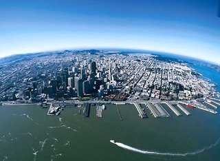
San Francisco area then inland and
then just south of San Francisco on
the coast (Second day symptoms -
Very Strong for Bay area)
philsland.blogs.com

--------------------------------------
2.2 2006/11/13 01:01:53 38.406 -122.221 4.7 12 km ( 8 mi) E of Yountville, CA
1.3 2006/11/13 00:59:19 38.416 -122.221 0.0 12 km ( 8 mi) E of Yountville, CA
1.3 2006/11/13 00:56:07 38.416 -122.206 6.1 14 km ( 8 mi) E of Yountville, CA
(Haven't found anything Very Strong)
Honshu, Japan (STRONG)
--------------------------------------
2006-11-13 22:29:31 4.8 23.03N 123.16E 10 Southwestern Ryukyu Islands, Japan
(Lower than expected)
COQUIMBO, CHILE (30.18S 71.28W)
(Medium
--------------------------------------
2006-11-13 01:26:33.3 26.08S 63.44W 553 mb6.4 SANTIAGO DEL ESTERO, ARGENTINA
2006-11-13 16:27:57 5.2 21.40S 52.34W 20 Brazil
2006-11-14 22:22:10.3 23.26S 68.43W 100 mb5.5 ANTOFAGASTA, CHILE
The Parkfield Fault/Northern area
(Probably going along with the
San Francisco post)
--------------------------------------
2.4 2006/11/12 23:56:26 37.937 -122.056 13.4 2 km ( 1 mi) SE of Pleasant Hill, CA
3.0 2006/11/13 09:19:39 36.239 -120.806 6.9 23 km ( 14 mi) ENE of San Lucas, CA
1.6 2006/11/13 19:40:24 36.606 -121.214 2.3 10 km ( 6 mi) NW of Pinnacles, CA
1.6 2006/11/13 20:35:41 36.961 -121.550 0.0 6 km ( 4 mi) SSE of Gilroy, CA
Sicily, Italy (38.09N 15.57E)
(Felt volcanic - Strong)
--------------------------------------
2006-11-13 23:33:46.8 43.91N 12.32E ML2.8 CENTRAL ITALY?
(Not Sicily and found nothing volcanic although Mt. Etna continues to
ooze lava slowly at times.)
Possibly Canary or Madeira Islands
(New symptom area)
--------------------------------------
2006-11-14 17:54:33.4 35.75N 14.47W 5 mb4.2 AZORES-CAPE ST. VINCENT RIDGE
(Also posted this on the 10th for a different symptom.)
Hydesville, CA (40.526 -124.052)/
Petrolia area
--------------------------------------
2.0 2006/11/13 20:13:18 39.548 -123.362 7.6 16 km ( 10 mi) N of Willits, CA?
3.4 2006/11/13 23:42:04 40.715 -124.593 13.0 32 km ( 20 mi) WNW of Ferndale, CA
New Madrid, MO area (36.490 -89.480)
--------------------------------------
1.6 2006/11/13 13:41:17 36.540 -89.610 7.6 3 km ( 2 mi) N of Marston, MO
1.5 2006/11/13 17:08:18 36.540 -89.610 7.6 3 km ( 2 mi) N of Marston, MO
Puerto Rico/Virgin Islands
--------------------------------------
2.7 2006/11/13 20:12:13 19.087N -64.833W 54.7 67 km (42 mi) NW of Settlement, Anegada, British Virgin Islands
3.3 2006/11/13 14:17:54 19.072N -64.873W 12.8 69 km (43 mi) WNW of Settlement, Anegada, British Virgin Islands
3.5 2006/11/13 05:58:47 18.053N -64.196W 16.1 39 km (24 mi) S of West End, Tortola, British Virgin Islands
3.2 2006/11/13 05:23:34 18.438N -65.655W 38.9 10 km ( 6 mi) NE of Luquillo, PR
2.9 2006/11/13 00:07:47 19.142N -65.885W 13.7 79 km (49 mi) N of Loíza, PR
Peace to all.

