*For Monday, 18 September 2006.
LEGEND for OVERVIEW: Size = My surety of area for quake.
Red Circle = Probable quake to STRONG quake.
Triangle = Very Strong/Stronger quake (Usually takes extra days).
Blue Circle, etc. = Uncertainty of symptom area for probable quake.
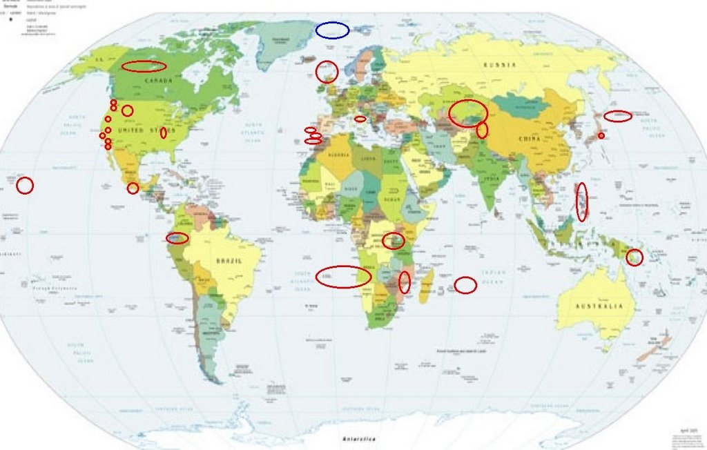
Places to watch.
Good luck to all.
For Monday, 18 September 2006.
---------------------------------------
Ireland/Scotland and North of
(Second day symptom - Strong)
---------------------------------------
NORWAY BASIN
Origin time Lat Lon Azres Timres Wres Nphase Ntot Nsta Netmag
2006-260:03.58.37.0 68.16 -5.08 15.50 3.90 7.77 2 2 1 2.48
NORWEGIAN SEA
Origin time Lat Lon Azres Timres Wres Nphase Ntot Nsta Netmag
2006-260:10.18.51.0 65.88 -8.15 15.26 2.32 6.14 3 4 2 1.94
SOUTHERN SCOTLAND
Origin time Lat Lon Azres Timres Wres Nphase Ntot Nsta Netmag
2006-261:03.39.36.0 55.66 -3.08 1.95 0.36 0.85 2 2 1 2.05
FAROES-HEBRIDES REGION
Origin time Lat Lon Azres Timres Wres Nphase Ntot Nsta Netmag
2006-261:03.42.32.0 60.49 -3.48 20.15 0.21 5.25 2 2 1 2.41
NORTHERN LOWER SAXONY AND HOLSTEIN
Origin time Lat Lon Azres Timres Wres Nphase Ntot Nsta Netmag
2006-261:07.55.30.0 53.26 9.58 10.49 0.23 2.85 3 5 3 1.99
Papua New Guinea area (Strong)
---------------------------------------
2006-09-18 01:41:18.3 6.18S 146.02E 116 mb5.3 EASTERN NEW GUINEA
The New Madrid Fault/Hayti, MO
area (36.270N 89.770W) (Medium)
---------------------------------------
1.3 2006/09/18 17:38:19 35.500 -85.090 17.6 6 km ( 4 mi) N of Graysville, TN
1.4 2006/09/18 23:13:40 36.270 -89.500 6.9 2 km ( 1 mi) WNW of Ridgely, TN
Kazakhstan/Kyrgyzstan area
---------------------------------------
2006-09-17 22:23:02.0 52.41N 78.95E ML3.2 EASTERN KAZAKHSTAN
2006-09-19 01:33:45.0 42.97N 78.93E ML3.5 KYRGYZSTAN
2006-09-19 13:29:11.0 39.70N 72.54E ML3.2 KYRGYZSTAN
Southern Mexico
---------------------------------------
(Nothing found)
SOUTHERN XINJIANG, CHINA
(38.44N 75.50E) and
also near Lake Baikal
---------------------------------------
2006-09-17 04:48:39.0 54.94N 111.63E 20 Ms4.1 LAKE BAYKAL, RUSSIA, REGION
2006-09-18 07:55:52.0 40.55N 79.45E ML4.6 SOUTHERN XINJIANG, CHINA
South of Kurils
---------------------------------------
2006-09-17 15:45:25.6 49.56N 154.85E 108 mb4.6 KURIL ISLANDS, RUSSIA
3.7 2006/09/17 17:33:37 52.185 -184.224 35.0 (no nearby locations in database)
2006-09-19 01:11:50.1 49.47N 156.07E 50 mb4.0 KURIL ISLANDS, RUSSIA
The Philippines (Non-specific)
(Medium)
---------------------------------------
2006-09-16 14:00:36 5.6 9.14N 129.76E 150 East of Philippine Islands
(2 days early)
Rancho Santa Margarita, CA area
(33.730 -117.487)
---------------------------------------
2.0 2006/09/18 03:13:53 33.076 -117.958 6.0 45 km ( 28 mi) SE of Avalon, CA
1.8 2006/09/18 10:34:13 32.725 -117.361 16.3 17 km ( 11 mi) SW of La Jolla, CA
2.7 2006/09/18 19:52:02 33.375 -118.113 6.0 20 km ( 13 mi) E of Avalon, CA
Montana/Idaho/Wyoming (Seems
to be a regular morning symptom but
also another symptom came in for
the same area - STRONG)
---------------------------------------
(Nothing found)
Mammoth Lakes/Tom’s Place (MEDIUM)
---------------------------------------
1.4 2006/09/18 15:57:08 37.625 -119.033 1.5 5 km ( 3 mi) WSW of Mammoth Lakes, CA
1.8 2006/09/19 08:35:47 37.531 -118.893 2.7 14 km ( 9 mi) SSE of Mammoth Lakes, CA
1.0 2006/09/19 08:22:20 37.631 -119.032 5.2 5 km ( 3 mi) W of Mammoth Lakes, CA
1.7 2006/09/19 08:18:42 37.629 -119.033 5.2 5 km ( 3 mi) W of Mammoth Lakes, CA
Central Italy (MEDIUM)
---------------------------------------
(Nothing found)
Peru/Ecuador area (MEDIUM)
---------------------------------------
2006-09-17 16:16:24.5 6.77N 72.92W 166 M4.5 NORTHERN COLOMBIA
2006-09-18 18:56:32 5.0 8.68S 74.51W 119 Peru-Brazil Border Region
St. Helena, Ca. area (38.495°N, 122.361°W)
(Medium)
---------------------------------------
(Nothing found)
LAKE TANGANYIKA REGION (6.96S 29.80E)
(Indication of depth - Strong)
---------------------------------------
(Nothing found)
Hawaii area
---------------------------------------
2.1 2006/09/18 00:53:41 19.299 -155.495 4.8 11 km ( 7 mi) N of Pahala, HI
1.8 2006/09/18 02:50:53 19.388 -155.247 3.2 7 km ( 4 mi) S of Volcano, HI
NORTH ATLANTIC OCEAN (36.85N 14.84W)
and somewhat North of
and Strait of Gibraltar/Morocco area
(Different areas - MEDIUM)
---------------------------------------
2006-09-19 12:53:34.9 41.70N 15.35W 245 ML4.3 NORTH ATLANTIC OCEAN
Guadalupe Victoria, Mexico
(31.887 -114.989)
and somewhat North of (Strong)
---------------------------------------
1.7 2006/09/19 03:36:24 32.375 -115.211 6.0 13 km(8 mi)NW of Guadalupe Victoria, Mexico
Honshu, Japan
---------------------------------------
(Nothing found)
Possibly Mohns Ridge (71.69 -1.57)
(Unproven symptom)
---------------------------------------
NORDLAND REGION NORWAY
Origin time Lat Lon Azres Timres Wres Nphase Ntot Nsta Netmag
2006-260:17.01.13.0 68.28 16.38 5.75 0.10 1.54 2 2 1 2.59
NORDLAND REGION NORWAY
Origin time Lat Lon Azres Timres Wres Nphase Ntot Nsta Netmag
2006-261:00.22.41.0 68.55 15.72 22.75 0.26 5.95 2 2 1 2.56
(I think this may be the region - I will watch for a repeat symptom.)
Yukon/Northwest Territories (Strong)
---------------------------------------
4.7 2006/09/18 06:13:20 66.597 -135.666 15.0 NORTHERN YUKON TERRITORY, CANADA
ESE of Alger, WA (48.614 -122.288)
---------------------------------------
(Nothing found)
MID-INDIAN RIDGE (24.34S 70.27E)
---------------------------------------
(Nothing found)
San Simeon, CA (35.721 -121.079)
---------------------------------------
1.7 2006/09/18 08:23:05 35.269 -120.778 8.4 7 km ( 5 mi) SE of Baywood-Los Osos, CA
Mt. St. Helen’s (Indication of
depth - Strong)
---------------------------------------
2.1 2006/09/18 01:25:01 46.199 -122.192 0.0 1 km ( 1 mi) W of Mount St. Helens Volcano, WA
2.3 2006/09/18 04:44:53 46.195 -122.194 0.8 1 km ( 1 mi) WSW of Mount St. Helens Volcano, WA
2.5 2006/09/18 11:59:47 46.196 -122.189 0.0 1 km ( 1 mi) WSW of Mount St. Helens Volcano, WA
2.3 2006/09/18 14:09:35 46.195 -122.195 0.0 1 km ( 1 mi) WSW of Mount St. Helens Volcano, WA
Mozambique
---------------------------------------
(Nothing found)
St. Helena to Angola area
---------------------------------------
(Nothing found)
Peace to all.

posted by Unknown @ 3:02 PM
0 comments
![]()
![]()
