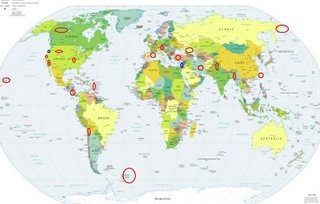
*For Wednesday, 26 April 2006.
LEGEND for OVERVIEW: Size = My surety of area for quake.
Red Circle = Probable quake to STRONG quake.
Triangle = Very Strong or Stronger quake (And usually takes extra days).
Blue Circle, etc. = Uncertainty of symptom area for probable quake.

Places to watch.
Good luck to all.
For Wednesday, 26 April 2006.
----------------------------------------
Iran (33.86N 48.69E)
----------------------------------------
2006-04-26 03:30:56.3 32.65 N 46.81 E 11 M 3.0 IRAN-IRAQ BORDER REGION
2006-04-27 13:08:04.8 33.42 N 48.58 E 21 M 3.2 WESTERN IRAN
Eastern Caucasus (43.2N 47.2E)
----------------------------------------
(Nothing found)
Eastern Siberia area (61.54 N 167.81 E) into Bering Sea area (STRONG)
----------------------------------------
2006-04-25 12:22:43.0 61.44 N 167.57 E 30 mb 5.0 EASTERN SIBERIA, RUSSIA
2006-04-26 16:37:04 4.9 61.15 N 166.02 E Eastern Siberia, Russia
Hawaii (MEDIUM)
----------------------------------------
(Nothing found)
San Francisco
----------------------------------------
MAP 1.8 2006/04/26 08:23:58 35.998 -120.878 15.9 4 km ( 2 mi) SE of San Ardo, CA
MAP 2.1 2006/04/26 09:56:59 35.978 -120.071 23.2 7 km ( 4 mi) SE of Avenal, CA
South Sandwich Islands area (MEDIUM)
----------------------------------------
(Nothing found)
Spain/France border area
----------------------------------------
2006-04-25 06:59:22.6 45.91 N 2.43 E 2 ML 2.8 FRANCE
2006-04-25 14:14:06.2 47.83 N 0.70 W 10 ML 2.7 FRANCE
2006-04-27 10:13:42.6 39.92 N 0.40 E mb 2.7 SPAIN
North of Marston, Missouri (36.480 -89.580 ) (MEDIUM)
----------------------------------------
MAP 1.5 2006/04/25 06:36:03 36.660 -89.540 7.0 8 km ( 5 mi) N of New Madrid, MO
MAP 1.5 2006/04/26 00:34:06 36.290 -89.500 7.9 3 km ( 2 mi) NNW of Ridgely, TN
MAP 1.4 2006/04/26 16:44:18 36.490 -89.570 9.4 5 km ( 3 mi) SE of Marston, MO
Chile/Bolivia border area (21.19S 68.41W)
----------------------------------------
2006-04-26 04:28:14.6 26.04 S 70.82 W 40 mb 4.7 NEAR COAST OF NORTHERN CHILE
Possibly Coburg, OR area (44.113 -123.031) (Medium)
----------------------------------------
MAP 3.0 2006/04/26 14:24:06 45.024 -122.555 19.1 9 km ( 6 mi) ESE of Scotts Mills, OR
Cabazon, California area (33.864 -116.786) (STRONG)
----------------------------------------
MAP 1.0 2006/04/25 23:19:49 33.825 -116.748 18.0 9 km ( 6 mi) NNW of Idyllwild, CA
MAP 1.2 2006/04/26 00:50:31 33.931 -116.373 9.5 13 km ( 8 mi) N of Thousand Palms, CA
MAP 2.0 2006/04/26 19:54:49 33.424 -116.613 13.5 16 km ( 10 mi) SSE of Anza, CA
MAP 1.1 2006/04/26 20:28:24 33.647 -116.705 16.2 11 km ( 7 mi) NNW of Anza, CA
MAP 1.3 2006/04/26 22:22:25 33.737 -116.108 12.5 9 km ( 6 mi) NE of Coachella, CA
MAP 1.0 2006/04/26 23:44:37 33.472 -116.475 15.8 20 km ( 13 mi) ESE of Anza, CA
MAP 1.2 2006/04/27 01:51:37 33.397 -116.392 15.2 17 km ( 10 mi) N of Borrego Springs, CA
MAP 1.0 2006/04/27 02:48:09 33.492 -116.380 15.8 22 km ( 14 mi) SSW of La Quinta, CA
MAP 1.6 2006/04/27 03:37:23 33.977 -116.912 17.9 5 km ( 3 mi) NNW of Banning, CA
(This is one of those instances when I get a horrible symptom and micro-quakes happen.)
Austria area
----------------------------------------
2006-04-25 11:40:10.2 42.95 N 26.07 E 650 ML 2.0 BULGARIA
Possibly Cyprus area (34.77 N 32.91 E)
----------------------------------------
2006-04-26 10:36:26.8 17.86N 40.20E 33 mb4.7 RED SEA
Taiwan area (2 different symptoms - Strong)
----------------------------------------
2006-04-28 09:05:24.5 23.97N 121.67E 5 mb5.1 TAIWAN
(2 extra days)
Pakistan/India border (STRONG)
----------------------------------------
(Nothing found)
Nicaragua/Costa Rica
----------------------------------------
06/04/26 18:15:19 12.48N 86.94W 98.4 2.9MC León
06/04/26 11:54:14 10.53N 86.28W 14.0 3.4MC Oceano Pacífico de Nicaragua
06/04/26 05:41:07 12.56N 87.80W 49.5 2.3ML Frente al Cosigüina
06/04/26 03:23:41 11.32N 85.44W 9.2 2.4MC Nicaragua
06/04/26 03:12:17 11.36N 85.50W 9.3 2.6MC Cerca del Volcán Maderas
Turkey
----------------------------------------
2006-04-26 12:40:14.9 38.66 N 35.69 E 13 MD 3.0 TURKEY
2006-04-26 14:18:22.1 37.50 N 38.71 E 9 MD 3.1 TURKEY
Big Bear City, California area (34.324 -116.854)
----------------------------------------
MAP 1.5 2006/04/26 21:56:05 33.787 -116.112 5.9 13 km ( 8 mi) NNE of Coachella, CA
MAP 1.3 2006/04/26 22:22:24 33.737 -116.109 15.8 9 km ( 5 mi) NE of Coachella, CA
Myanmar/India border (23.23N 94.85E)
----------------------------------------
2006-04-25 13:18:22 5.1 25.19 N 94.50 E Myanmar-India Border Region
Yukon/Northwest Territories
----------------------------------------
2006/04/26 15:15:52 66.22N 135.77W 20.0g 2.6ML PGC 148 km SW of Ft. McPherson, NT
Wyoming/Montana/Yellowstone (Second day of symptoms - Strong)
----------------------------------------
MAP 1.1 2006/04/25 07:49:29 47.286 -113.216 18.7 23 km ( 14 mi) NE of Seeley Lake, MT
MAP 1.2 2006/04/26 06:37:27 44.798 -111.038 7.3 16 km ( 10 mi) NNE of West Yellowstone, MT
The Virgin Islands
----------------------------------------
MAP2.8 2006/04/26 00:17:24 18.633 -65.001 30.1 32 km ( 20 mi) NNW of CHARLOTTE AMALIE, US Virgin Islands
MAP3.9 2006/04/26 01:33:52 17.982 -63.612118.0 55 km ( 34 mi) NW of The Bottom, Netherlands Antilles
MAP2.9 2006/04/26 03:10:14 18.470 -67.455 8.4 26 km ( 16 mi) NW of Rincón, PR
MAP3.0 2006/04/26 03:51:00 18.618 -64.971 29.7 30 km ( 19 mi) N of CHARLOTTE AMALIE, US Virgin Islands
MAP3.4 2006/04/26 04:48:32 18.170 -64.856139.3 19 km ( 12 mi) S of Anna's Retreat, US Virgin Islands
MAP2.2 2006/04/26 05:02:52 17.906 -66.936 13.4 8 km ( 5 mi) SSW of Guánica, PR
MAP2.8 2006/04/26 16:06:34 18.657 -66.789 74.5 19 km ( 12 mi) N of Carrizales, PR
MAP2.6 2006/04/26 16:58:16 18.667 -65.020 14.8 36 km ( 23 mi) NNW of CHARLOTTE AMALIE, US Virgin Islands
MAP2.5 2006/04/26 16:55:43 18.907 -65.273 24.6 67 km ( 42 mi) N of Culebra, PR
MAP2.6 2006/04/26 19:19:53 18.828 -67.367 10.4 49 km ( 30 mi) NNW of Cabán, PR
MAP2.1 2006/04/26 21:03:10 18.006 -65.458 15.9 11 km ( 7 mi) S of Esperanza, PR
MAP1.0 2006/04/26 21:57:08 17.973 -66.957 8.5 4 km ( 2 mi) W of Guánica, PR
Peace to all.

