*For Monday, 19 June 2006.
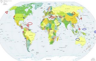
LEGEND for OVERVIEW: Size = My surety of area for quake.
Red Circle = Probable quake to STRONG quake.
Triangle = Very Strong/Stronger quake (Usually takes extra days).
Blue Circle, etc. = Uncertainty of symptom area for probable quake.

Places to watch.
Good luck to all.
For Monday, 19 June 2006.
----------------------------------------
Possibly Western Australia (17.23S 128.34E)
(Unproven symptom)
----------------------------------------
2006-06-19 14:53:05.9 22.29N 94.68E 102mb 5.1 MYANMAR
2006-06-19 16:57:35.2 25.78N 90.87E 33 mb 4.7 INDIA-BANGLADESH BORDER REG.
(Possible area - must wait for a repeat.)
Turkey to Aegean Sea
----------------------------------------
2006-06-19 15:02:56.0 37.27N 27.88E 23 MD 2.7 TURKEY
2006-06-19 22:32:01.5 40.67N 34.89E 11 MD 3.0 TURKEY
Sicily, Italy/Ionian Sea (Strong)
----------------------------------------
2006-06-19 15:11:57.0 37.84N 14.89E 26 ML 2.8 SICILY, ITALY
2006-06-19 21:27:12.0 37.82N 14.88E 20 ML 2.9 SICILY, ITALY
2006-06-19 21:20:12.0 37.85N 14.87E 22 ML 3.0 SICILY, ITALY
2006-06-19 20:55:34.0 37.85N 14.88E 26 ML 3.8 SICILY, ITALY
Possibly New Madrid Fault at Gatlinburg, Tennessee/North Carolina
(35.608 -83.411) (New unproven symptom) (Very Strong -
I felt this symptom strong 4 times. This quake should prove
or disprove the area.)
http://earthquake.usgs.gov/eqcenter/recenteqsus/Quakes/uspaad.php>USGS

----------------------------------------
map 1.8 2006/06/22 08:44:13 34.550N 85.250W 9.7 6 km ( 3 mi) E of Trion, GA
map 2.1 2006/06/22 08:42:36 34.550N 85.250W 9.6 6 km ( 3 mi) E of Trion, GA
(If this is right - it is 3 days early!! Or something bigger as late as the 25th of June.)
Almanor, California area (40.218 -121.180)
----------------------------------------
(Nothing found)
Mindanao, Philippines (7.82N 125.20E)
----------------------------------------
2006-06-19 05:47:53.7 12.73N 125.25E 40 mb5.3 SAMAR, PHILIPPINE ISLANDS
Nicaragua/Costa Rica area
----------------------------------------
06/06/19 08:49:59 11.10N 85.73W 168.9 3.4MC Rivas
06/06/19 01:58:18 11.78N 86.64W 86.6 2.7MC Frente a Masachapa
06/06/19 22:57:40 12.81N 87.03W 1.9 2.1MC Nicaragua
06/06/19 22:00:19 11.42N 86.93W 87.7 3.2MC Frente a Masachapa
06/06/19 20:48:35 12.39N 87.45W 34.9 3.1MC Frente a Corinto
06/06/19 08:49:55 11.09N 85.56W 197.6 3.5MC Nicaragua
06/06/19 01:58:18 11.81N 86.62W 88.7 2.7MC Frente a Masachapa
The Virgin Islands area then North into the Atlantic and then Puerto Rico
----------------------------------------
18Jun2006 18:28:02.3 33.0N 39.6W 10 M =5.9 M*NEI NORTHERN MID-ATLANTIC RIDG
18Jun2006 19:06:30.9 33.0N 38.6W 33 MS=4.7 M GSR NORTHERN MID-ATLANTIC RIDG
18Jun2006 20:49:13.3 33.1N 39.2W 33 mb=4.7 M GSR NORTHERN MID-ATLANTIC RIDG
3.2 2006/06/19 03:25:35 18.892 -64.082 52.9 31 km ( 19 mi) NE of Settlement, British Virgin Islands
3.3 2006/06/19 07:27:39 19.041 -64.146 52.6 39 km ( 24 mi) NNE of Settlement, British Virgin Islands
3.0 2006/06/19 07:20:13 18.135 -66.983 12.2 5 km ( 3 mi) S of Maricao, PR
3.5 2006/06/19 08:07:02 19.192 -64.246 16.1 52 km ( 32 mi) N of Settlement, British Virgin Islands
2.2 2006/06/19 10:06:35 17.749 -66.889 17.4 25 km ( 16 mi) S of Guánica, PR
Poland (Medium)
----------------------------------------
2006-06-18 21:15:50.1 50.98N 16.27E ML 2.2 POLAND
South of the Aleutians (52.868 -165.508) (I did not feel any
symptoms for the swarm here: 6.4 2006/06/14 04:18:42 51.802
177.059 14.0 RAT ISLANDS, ALEUTIAN ISLANDS, ALASKA and the
continuing swarm of quakes. But the symptom I felt this time which
is the whole area at the very top of my spine felt like a dislocation.
I think there will be a stronger than 6.4 in this area and it may take
extra days - as much as 5 or more so be prepared until around the
24th or so. This may be the Aleutian Trench movement and may
spawn a tsunami. - EXTREMELY STRONG.)
http://www.giseis.alaska.edu/Input/affiliated/doerte/personal/aleutians/general.html >giseis

----------------------------------------
3.7 2006/06/19 05:03:45 52.041 177.259 15.0 RAT ISLANDS, ALEUTIAN ISLANDS, ALASKA
2.8 2006/06/19 23:38:09 51.864 178.084 20.0 RAT ISLANDS, ALEUTIAN ISLANDS, ALASKA
3.6 2006/06/20 00:30:58 51.836 177.114 1.0 RAT ISLANDS, ALEUTIAN ISLANDS, ALASKA
3.7 2006/06/21 00:44:52 52.035 177.097 5.0 RAT ISLANDS, ALEUTIAN ISLANDS, ALASKA
3.2 2006/06/21 08:33:23 51.731 176.962 1.0 RAT ISLANDS, ALEUTIAN ISLANDS, ALASKA
3.4 2006/06/21 10:13:19 51.836 177.114 1.0 RAT ISLANDS, ALEUTIAN ISLANDS, ALASKA
4.2 2006/06/21 11:17:05 51.731 176.962 1.0 RAT ISLANDS, ALEUTIAN ISLANDS, ALASKA
3.3 2006/06/21 12:01:37 52.062 177.287 50.0 RAT ISLANDS, ALEUTIAN ISLANDS, ALASKA
3.6 2006/06/21 12:06:33 51.777 177.177 15.0 RAT ISLANDS, ALEUTIAN ISLANDS, ALASKA
2.7 2006/06/21 12:24:11 51.384 179.077 25.0 RAT ISLANDS, ALEUTIAN ISLANDS, ALASKA
3.5 2006/06/21 14:03:59 51.836 177.114 1.0 RAT ISLANDS, ALEUTIAN ISLANDS, ALASKA
3.3 2006/06/21 15:07:47 51.731 176.962 1.0 RAT ISLANDS, ALEUTIAN ISLANDS, ALASKA
2.7 2006/06/21 18:22:36 51.295 179.881 30.0 RAT ISLANDS, ALEUTIAN ISLANDS, ALASKA
3.7 2006/06/21 19:00:18 52.035 177.097 1.0 RAT ISLANDS, ALEUTIAN ISLANDS, ALASKA
(2 extra days and this area is still moving.)
Ecuador area
----------------------------------------
4.0 2006/06/19 05:09:37 -1.561 -98.756 246.7 WEST OF THE GALAPAGOS ISLANDS
4.4 2006/06/19 14:04:02 3.498 -102.120 10.0 GALAPAGOS TRIPLE JUNCTION REGION
2006-06-21 12:41:01.3 1.51S 77.38W 177 mb 5.2 ECUADOR
(2 extra days)
Possibly Palau/Caroline Islands area
(Unproven symptom)
----------------------------------------
18Jun2006 08:04:37.8 16.0N 146.6E 33 mb=4.8 M GSR MARIANA ISLANDS
Honshu, Japan (Medium)
----------------------------------------
2006-06-19 21:47:10.5 35.69N 139.96E 80 mb4.8 NEAR S.CST OF EASTERN HONSHU
Russia/China/Mongolia border area (Medium)
----------------------------------------
(Nothing found)
Possibly Glbert Islands/Marshall Islands area
(Unproven symptom) (Strong)
----------------------------------------
(Nothing found)
San Francisco area (Non-specific)
----------------------------------------
(Nothing found)
Possibly Off the Coast of Northern Chile (18.19S 71.08W)
(Unproven symptom)
----------------------------------------
2006-06-20 02:13:47 5.2 32.82S 71.64W Near Coast of Central Chile
Possibly Santa Maria to San Luis Obispo (Unproven symptom)
----------------------------------------
2.3 2006/06/18 13:12:11 34.816 -120.461 3.9 7 km ( 4 mi) SSW of Orcutt, CA
Peace to all.

