*For Sunday, 4 June 2006.
LEGEND for OVERVIEW: Size = My surety of area for quake.
Red Circle = Probable quake to STRONG quake.
Triangle = Very Strong or Stronger quake (And usually takes extra days).
Blue Circle, etc. = Uncertainty of symptom area for probable quake.
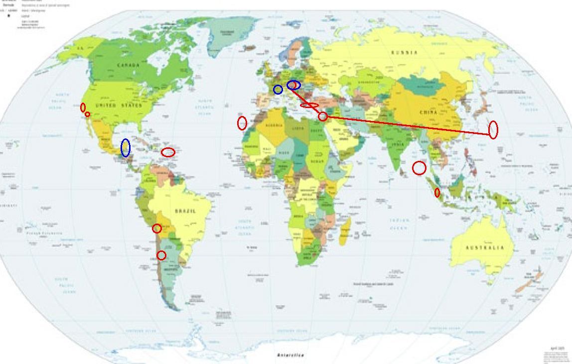
Places to watch.
Good luck to all.
For Sunday, 4 June 2006.
----------------------------------------
Volcano Islands (22.09 N 144.48 E) area then Cyprus area and then Austria area (47.01N 13.32E) (This symptom started with a strong pinch for Mariana Islands and then seemed to go immediately to the other two areas...so I am posting them together. Strong for Volcano Islands.)
----------------------------------------
04Jun2006 20:13:49.2 21.2N 143.0E 50 mb=4.9 M*GSR MARIANA ISLANDS REGION
04Jun2006 20:21:01.1 21.3N 143.8E 33 mb=4.7 M GSR MARIANA ISLANDS REGION
2006-06-04 01:44:31.6 35.13 N 32.81 E 50 ML 3.2 CYPRUS REGION
(Nothing specific for Austria)
Nicobar/Andaman Islands area
----------------------------------------
2006-06-03 13:01:13 4.9 12.48 N 91.76 E Andaman Islands, India Region
Possibly France (43.17N 7.62E) or Austria area (Unproven symptom - MEDIUM)
----------------------------------------
2006-06-04 01:59:14.1 45.10 N 6.52 E 2 ML 2.1 FRANCE
2006-06-05 14:47:48.8 43.20 N 0.65 W 2 ML 2.7 PYRENEES
Chile-Bolivia border area (21.19S 68.41W) then Coquimbo, Chile area (-30.912 -72.015) (Volcanic)
----------------------------------------
2006-06-06 13:57:49 5.2 20.89 S 69.16 W Northern Chile
(2 extra days - nothing for Coquimbo)
Greece/Turkey area
----------------------------------------
2006-06-03 07:07:51.3 38.70 N 27.58 E 15 MD 3.1 TURKEY
2006-06-03 08:11:53.2 38.73 N 25.39 E 28 ML 3.1 AEGEAN SEA
2006-06-03 08:08:44.1 38.81 N 25.57 E 30 MD 3.4 AEGEAN SEA
2006-06-03 08:45:28.0 36.70 N 25.16 E ML 3.1 DODECANESE ISLANDS, GREECE
2006-06-03 11:07:44.6 37.68 N 43.55 E 5 mb 4.4 TURKEY
2006-06-03 14:40:26.2 39.12 N 40.34 E 10 mb 4.5 TURKEY
2006-06-03 16:32:23.4 38.77 N 27.83 E 13 ML 3.3 TURKEY
2006-06-04 06:06:52.6 37.83 N 28.84 E 27 MD 3.2 TURKEY
2006-06-04 11:26:28.2 37.89 N 28.79 E 27 MD 2.9 TURKEY
2006-06-04 11:24:18.6 37.88 N 28.75 E 25 MD 2.9 TURKEY
2006-06-04 11:07:43.0 37.83 N 28.81 E 29 MD 3.1 TURKEY
2006-06-04 11:05:14.7 37.86 N 28.82 E 29 MD 3.2 TURKEY
2006-06-04 10:46:28.0 37.82 N 28.84 E 26 MD 2.8 TURKEY
2006-06-04 09:13:25.8 37.01 N 28.05 E 30 MD 2.8 TURKEY
2006-06-05 04:23:30.0 37.95 N 28.68 E 10 mb 4.5 TURKEY
2006-06-05 04:38:42.6 37.92 N 28.69 E 5 ML 4.0 TURKEY
2006-06-05 06:40:57.6 37.93 N 28.71 E 9 MD 3.1 TURKEY
2006-06-05 06:35:23.0 37.92 N 28.70 E 8 MD 3.0 TURKEY
2006-06-05 09:46:50.3 35.13 N 26.78 E 40 mb 4.1 CRETE, GREECE
2006-06-05 08:50:20.5 37.88 N 28.78 E 29 MD 3.2 TURKEY
2006-06-05 12:00:17.4 37.89 N 28.80 E 25 MD 2.9 TURKEY
2006-06-05 11:21:10.3 38.62 N 40.12 E 32 MD 3.2 TURKEY
Possibly Belize or Yucatan Peninsula (New symptom)
----------------------------------------
06/06/04 11:09:10 10.98N 85.17W 142.2 3.0ML Costa Rica
06/06/04 07:04:28 11.72N 85.77W 22.4 2.0MC Cerca de Isla de Zapatera
06/06/04 05:43:52 11.99N 86.66W 94.3 2.6ML Frente a Masachapa
06/06/04 02:19:01 11.64N 87.78W 9.3 2.9ML Oceano Pacífico de Nicaragua
(Certainly not as far North as expected.)
Puerto Rico/Virgin Islands (Volcanic)
----------------------------------------
MAP 3.2 2006/06/03 03:52:10 18.383 -67.731 116.1 51 km ( 32 mi) W of Rincón, PR
MAP 2.0 2006/06/03 11:24:42 17.811 -66.945 18.7 18 km ( 11 mi) S of Guánica, PR
MAP 2.8 2006/06/03 17:56:07 17.998 -67.072 7.4 4 km ( 2 mi) NW of La Parguera, PR
MAP 3.4 2006/06/03 18:46:49 17.972 -65.576 41.6 17 km ( 11 mi) SW of Esperanza, PR
MAP 3.3 2006/06/05 11:28:44 18.040N -64.704W 116.5 32 km (20 mi) N of Christiansted, Saint Croix, US Virgin Islands
Canary Islands area (28.00N 16.24W)
----------------------------------------
2006-06-07 04:03:44.7 35.92 N 10.37 W 30 f ML 3.2 NORTH ATLANTIC OCEAN
(3 extra days also posted on the 6th - rethinking symptom location.)
Parkfield Fault/Parkfield area
----------------------------------------
MAP 1.7 2006/06/03 07:04:34 35.992 -120.570 3.1 16 km ( 10 mi) NW of Parkfield, CA
Yucaipa, California (34.025 -117.021)
----------------------------------------
MAP 1.6 2006/06/03 04:52:13 34.002 -116.967 17.7 8 km ( 5 mi) ESE of Yucaipa, CA
MAP 1.4 2006/06/03 10:41:19 34.056 -116.618 9.4 3 km ( 2 mi) W of Morongo Valley, CA
MAP 1.5 2006/06/04 16:03:13 34.694 -116.278 1.9 11 km ( 7 mi) WSW of Ludlow, CA
MAP 1.4 2006/06/04 16:55:49 34.463 -116.234 8.1 27 km ( 17 mi) NNW of Twentynine Palms Base, CA
MAP 2.2 2006/06/05 10:17:42 34.233 -116.869 1.4 4 km ( 2 mi) ESE of town of Big Bear Lake, CA
MAP 1.4 2006/06/05 10:26:39 34.236 -116.870 3.0 4 km ( 2 mi) ESE of town of Big Bear Lake, CA
MAP 1.6 2006/06/05 12:06:17 34.235 -116.869 1.8 4 km ( 2 mi) SW of Big Bear City, CA
MAP 2.3 2006/06/05 12:04:20 34.233 -116.867 2.8 4 km ( 2 mi) SSW of Big Bear City, CA
MAP 1.8 2006/06/05 17:05:31 34.028 -117.243 18.8 2 km ( 1 mi) SSE of Loma Linda, CA
Sumatra
----------------------------------------
2006-06-05 04:26:37.9 2.23 N 96.69 E 30 mb 5.2 NORTHERN SUMATERA, INDONESIA
Peace to all.

posted by Unknown @ 2:08 PM
0 comments
![]()
![]()
