*For Tuesday, 17 October 2006.
LEGEND for OVERVIEW: Size = My surety of area for quake.
Red Circle = Probable quake to STRONG quake.
Triangle = Very Strong/Stronger quake (Usually takes extra days).
Blue Circle, etc. = Uncertainty of symptom area for probable quake.
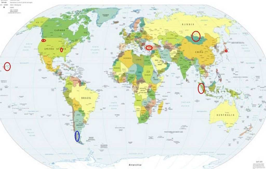
Places to watch.
Good luck to all.
(I missed many symptoms for
this day - very busy days mean
subtle symptoms aren’t even
felt.)
For Tuesday, 17 October 2006.
--------------------------------------
The New Madrid Fault (Non-specific)
--------------------------------------
2.8 2006/10/17 05:18:04 35.230 -92.290 3.8 8 km ( 5 mi) N of Holland, AR
1.5 2006/10/17 14:28:29 36.270 -89.460 6.1 2 km ( 1 mi) ENE of Ridgely, TN
1.5 2006/10/17 20:18:56 36.480 -89.560 9.2 6 km ( 4 mi) SE of Marston, MO
Mt. St. Helen’s
--------------------------------------
2.1 2006/10/17 02:57:32 46.194 -122.192 0.0 1 km ( 1 mi) SW of Mount St. Helens Volcano, WA
1.5 2006/10/17 07:13:47 46.194 -122.195 0.0 1 km ( 1 mi) WSW of Mount St. Helens Volcano, WA
1.2 2006/10/17 14:19:28 46.194 -122.195 1.0 1 km ( 1 mi) WSW of Mount St. Helens Volcano, WA
2.3 2006/10/17 15:51:46 46.196 -122.196 0.0 1 km ( 1 mi) WSW of Mount St. Helens Volcano, WA
1.7 2006/10/17 19:50:05 46.195 -122.191 0.0 1 km ( 1 mi) SW of Mount St. Helens Volcano, WA
Mt. Rainier area/Greenwater, WA.
(46.850 -121.594)(MEDIUM)
--------------------------------------
1.2 2006/10/17 15:33:38 46.527N 122.415W 18.4 5 km ( 3 mi) E of Mossyrock, WA
1.6 2006/10/17 14:58:47 47.766N 122.011W 0.0 3 km ( 2 mi) ESE of Echo Lake, WA
Possibly OFFSHORE LOS LAGOS, CHILE
(Unproven symptom)
(-42.811 -74.175)(Strong)
--------------------------------------
2006-10-16 01:33:34.4 30.18S 71.28W 40f mb5.3 COQUIMBO, CHILE
Hawaii (MEDIUM)
--------------------------------------
2.6 2006/10/18 00:32:01 20.043 -155.846 13.2 12 km ( 8 mi) N of Puako, HI
2.5 2006/10/18 00:18:42 19.801 -155.391 10.6 26 km ( 16 mi) SW of Laupahoehoe, HI
2.0 2006/10/17 19:44:35 19.840 -155.107 14.6 0 km ( 0 mi) NNW of Pepeekeo, HI
2.7 2006/10/17 18:49:23 19.852 -155.946 41.4 12 km ( 8 mi) SW of Puako, HI
3.5 2006/10/17 16:57:33 19.987 -156.028 43.5 18 km ( 11 mi) WNW of Puako, HI
2.4 2006/10/17 15:34:38 20.022 -156.047 11.0 21 km ( 13 mi) WNW of Puako, HI
3.9 2006/10/17 15:26:45 20.029 -155.957 12.6 14 km ( 9 mi) NW of Puako, HI
2.1 2006/10/17 12:21:54 19.889 -155.919 16.8 7 km ( 5 mi) SW of Puako, HI
2.4 2006/10/17 11:23:35 19.822 -156.245 14.5 27 km ( 17 mi) WNW of Kalaoa, HI
3.2 2006/10/17 06:20:33 20.090 -156.158 11.6 35 km ( 22 mi) WNW of Puako, HI
2.2 2006/10/17 05:40:38 19.476 -154.887 0.0 4 km ( 2 mi) E of Leilani Estates, HI
2.0 2006/10/17 05:00:18 19.593 -155.848 23.7 9 km ( 6 mi) ENE of Honalo, HI
1.8 2006/10/17 04:15:35 19.898 -155.921 12.6 7 km ( 4 mi) WSW of Puako, HI
2.1 2006/10/17 04:05:22 19.939 -156.179 14.8 30 km ( 19 mi) NW of Kalaoa, HI
Turkey (medium)
--------------------------------------
2006-10-16 00:29:10.9 37.44N 38.82E 5 MD3.0 TURKEY
2006-10-16 04:08:36.1 39.01N 33.07E 17 MD2.9 TURKEY
2006-10-16 12:01:06.5 39.90N 40.30E 26 MD3.4 TURKEY
2006-10-16 12:52:41.6 39.83N 40.32E 12 MD3.3 TURKEY
2006-10-16 12:47:53.7 39.86N 40.56E 26 MD3.0 TURKEY
2006-10-16 23:34:35.0 39.26N 26.20E ML3.0 TURKEY
2006-10-17 02:54:01.0 39.21N 26.90E ML4.0 TURKEY
2006-10-17 04:42:13.0 39.70N 26.60E ML4.0 TURKEY
2006-10-17 14:09:03.5 40.02N 38.82E 24 MD2.9 TURKEY
2006-10-17 19:40:35.6 40.88N 31.05E 5 ML3.4 TURKEY
Honshu, Japan
--------------------------------------
2006-10-17 19:19:10.2 37.77N 142.63E 20 mb5.1 OFF EAST COAST OF HONSHU, JAPAN
Mongolia/Lake Baykal area
--------------------------------------
15Oct2006 23:34:07.9 52.5N 106.7E 10 MS=3.4 M GSR LAKE BAYKAL REGION, RUSSIA
(2 days early)
Sumatra
--------------------------------------
2006-10-17 07:59:12 5.1 10.20N 91.80E 10 Andaman Islands, India Region
Peace to all.

posted by Unknown @ 3:57 PM
0 comments
![]()
![]()
