*For Sunday, 24 December 2006.
LEGEND for OVERVIEW: Size = My surety of area for quake.
Red Circle = Probable quake to STRONG quake.
Triangle = Very Strong/Stronger quake (Usually takes extra days).
Blue Circle, etc. = Uncertainty of symptom area for probable quake.
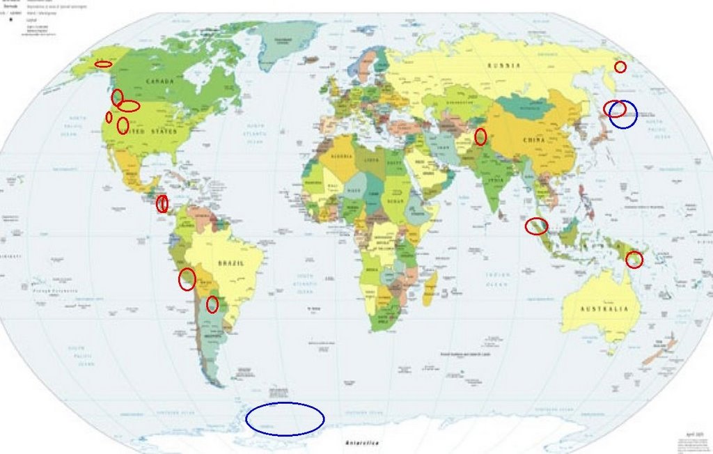
Places to watch.
Good luck to all.
For Sunday, 24 December 2006.
--------------------------------------
Montana/Idaho/possibly Eastern
Washington area
--------------------------------------
1.5 2006/12/24 01:15:45 46.769 -112.615 0.9 19 km ( 12 mi) N of Avon, MT
2 Possibilities - Kurils or
Antarctica (This symptom
is still not settled -
last time I had it there were
quakes in both areas)
--------------------------------------
2006-12-23 10:36:26.6 46.52N 153.00E 80 mb4.4 KURIL ISLANDS
2006-12-23 08:11:54.7 46.47N 155.26E 10 mb4.5 EAST OF KURIL ISLANDS
Sumatra (1.19N 97.06E)
--------------------------------------
(Nothing found)
Nicaragua/Costa Rica area
--------------------------------------
06/12/23 11:52:44 10.63N 84.89W 16.7 3.3ML Costa Rica
06/12/23 21:15:08 12.22N 86.29W 4.5 2.1MC Sur del Lago de Managua
06/12/23 03:26:46 12.68N 88.29W 10.5 3.1ML Frente al Golfo de Fonseca
06/12/24 03:17:58 12.63N 90.79W 15.0 4.9MC Frente a El Salvador
Islamabad, Pakistan area
--------------------------------------
2006-12-24 14:07:33.0 41.29N 52.94E ML4.8 TURKMENISTAN
2006-12-24 10:11:07.0 40.65N 70.50E ML3.0 TAJIKISTAN
2006-12-24 06:39:15.0 39.03N 73.31E ML3.5 TAJIKISTAN
2006-12-25 20:12:02.0 42.94N 76.18E ML3.5 EASTERN KAZAKHSTAN
2006-12-25 20:01:01.8 42.23N 76.06E 30 mb5.7 KYRGYZSTAN
2006-12-25 03:43:44.0 40.80N 72.88E ML3.1 EASTERN UZBEKISTAN
2006-12-25 02:51:56.0 40.74N 73.35E ML3.0 KYRGYZSTAN
Northeastern Siberia
--------------------------------------
(Nothing found)
Peru
--------------------------------------
5.0 2006/12/24 07:28:01 -11.719 -77.621 41.7 NEAR THE COAST OF CENTRAL PERU
Sandspit BC area (52.70N 132.01W)
(Indication of depth - Strong.)
--------------------------------------
2006/12/24 06:09:20 50.19N 127.81W 6.0 1.8ML 62 km SW of Pt. Hardy,BC
2006/12/24 05:27:05 49.08N 122.63W 77.0 1.7ML 2 km SE of Langley,BC
2006/12/24 05:25:35 51.63N 130.63W 1.0* 2.8ML 182 km SW of Bella Bella,BC
JUJUY, ARGENTINA (-23.879 -66.601)
(5 repeat symptoms - STRONG.)
--------------------------------------
4.5 2006/12/26 06:33:19 -22.299 -65.563 256.3 JUJUY, ARGENTINA
(2 extra days and also posted on the 26th)
Utah/Nevada (Non-specific but
indication of depth - Strong)
--------------------------------------
06/12/23 06:41:29 39.53N 110.97W 5.0 1.9 9.8 mi SW of Price
06/12/23 09:01:40 41.66N 112.39W 5.5 1.4 12.1 mi WSW of Tremonton
06/12/23 15:53:11 39.74N 110.74W 0.2 1.2 7.0 mi NE of Helper
06/12/23 16:55:14 41.52N 111.64W 7.6 1.3 11.0 mi E of Paradise
06/12/23 19:37:54 39.74N 110.74W 0.0 1.3 7.0 mi NE of Helper
06/12/23 20:28:00 39.74N 110.74W 0.1 1.1 7.1 mi NE of Helper
06/12/23 22:24:40 39.74N 110.75W 0.4 1.1 6.6 mi NE of Helper
2.4 2006/12/24 03:55:17 38.211 -118.628 0.0 14 km ( 9 mi) SW of Qualeys Camp, NV
2.0 2006/12/24 22:35:57 36.991 -116.350 0.0 37 km ( 23 mi) ENE of Beatty, NV
(Nothing deep)
Papua New Guinea area
--------------------------------------
5.5 2006/12/24 05:07:38 -4.533 153.175 64.2 NEW IRELAND REGION, PAPUA NEW GUINEA
5.3 2006/12/24 09:46:26 -5.204 144.882 64.5 NEW GUINEA, PAPUA NEW GUINEA
2006-12-24 17:39:07.4 2.12S 139.04E 29 M5.7 NEAR N COAST OF PAPUA, INDONESIA
2006-12-24 17:39:02.7 2.09S 139.03E 10 Mw5.7 NEAR N COAST OF PAPUA, INDONESIA
2006-12-27 20:15:39.5 5.78S 154.37E 371 Mw6.0 BOUGAINVILLE REGION, P.N.G.
(3 extra days)
Kuril Islands (47.6N 155.2E)
--------------------------------------
2006-12-23 10:36:26.6 46.52N 153.00E 80 mb4.4 KURIL ISLANDS
2006-12-23 08:11:54.7 46.47N 155.26E 10 mb4.5 EAST OF KURIL ISLANDS
2006-12-23 17:56:56 4.9mb 47.04N 155.20E 10 East of Kuril Islands
2006-12-25 15:37:50.2 46.94N 152.85E 80 mb4.8 KURIL ISLANDS
2006-12-26 07:57:58 4.8mb 46.15N 154.47E 20 East of Kuril Islands
2006-12-26 15:19:48 5.7mb 48.42N 154.79E 30 Kuril Islands
Frente a Poneloya (12.10N 87.20W)/
possibly Honduras (May go along with
the Nicaragua/Costa Rica
symptom - making it Strong)
--------------------------------------
06/12/23 03:55:06 11.73N 87.34W 11.7 3.9ML Frente a Puerto Sandino
06/12/24 23:48:37 12.18N 86.96W 61.5 2.5MC Frente a Puerto Sandino
Southern Oregon/Northern California
(Non-specific)
--------------------------------------
1.3 2006/12/24 19:06:21 45.023 -122.580 15.9 7 km ( 4 mi) ESE of Scotts Mills, OR
2.0 2006/12/24 22:03:52 45.120 -120.930 16.1 13 km ( 8 mi) ESE of Maupin, OR
2.5 2006/12/24 23:39:30 44.908 -122.593 14.8 13 km ( 8 mi) NNE of Mehama, OR
Southern Alaska
--------------------------------------
2.5 2006/12/23 02:33:03 61.539 -149.644 60.0 SOUTHERN ALASKA
3.8 2006/12/25 11:10:49 61.507 -146.541 25.0 SOUTHERN ALASKA
3.1 2006/12/25 11:05:31 59.841 -152.505 80.0 SOUTHERN ALASKA
Peace to all.

posted by Unknown @ 2:20 PM
0 comments
![]()
![]()
