*For Wednesday, 3 May 2006.
LEGEND for OVERVIEW: Size = My surety of area for quake.
Red Circle = Probable quake to STRONG quake.
Triangle = Very Strong or Stronger quake (And usually takes extra days).
Blue Circle, etc. = Uncertainty of symptom area for probable quake.
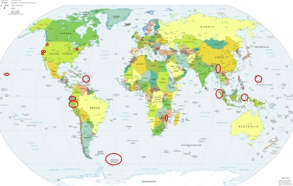
Places to watch.
Good luck to all.
For Wednesday, 3 May 2006.
----------------------------------------
Puerto Rico/Virgin Islands (STRONG)
----------------------------------------
MAP 3.2 2006/05/02 00:46:09 18.886 -67.649 10.0 72 km ( 45 mi) NW of Aguadilla, PR
MAP 3.0 2006/05/02 05:37:27 19.087 -64.725 8.6 58 km ( 36 mi) NW of Settlement, British Virgin Islands
MAP 3.0 2006/05/02 05:18:05 18.876 -64.410 8.8 19 km ( 12 mi) NNW of Settlement, British Virgin Islands
MAP 3.1 2006/05/02 06:10:04 19.232 -66.821 26.9 83 km ( 52 mi) N of Hatillo, PR
MAP 3.5 2006/05/02 06:47:11 19.208 -66.762 33.1 81 km ( 50 mi) N of Hatillo, PR
MAP 3.3 2006/05/02 12:25:44 17.855 -68.306 86.9 95 km ( 59 mi) SE of La Romana, Dominican Republic
MAP 2.4 2006/05/02 14:20:12 18.867 -64.312 32.7 15 km ( 10 mi) N of Settlement, British Virgin Islands
MAP 2.9 2006/05/02 15:14:25 17.828 -67.960 24.7 83 km ( 52 mi) W of Pole Ojea, PR
MAP 2.3 2006/05/02 15:50:07 18.649 -66.494 15.4 21 km ( 13 mi) N of Tierras Nuevas Poniente, PR
MAP 1.5 2006/05/02 17:01:41 17.989 -67.052 6.6 2 km ( 1 mi) NNW of La Parguera, PR
MAP 3.1 2006/05/02 17:11:19 17.887 -67.825 59.0 68 km ( 42 mi) W of Pole Ojea, PR
MAP 3.3 2006/05/02 22:19:35 19.096 -64.400 48.0 42 km ( 26 mi) NNW of Settlement, British Virgin Islands
MAP 2.9 2006/05/02 23:39:41 19.140 -64.438 40.5 47 km ( 29 mi) NNW of Settlement, British Virgin Islands
MAP 3.1 2006/05/02 23:52:10 19.153 -66.781 44.2 74 km ( 46 mi) N of Hatillo, PR
The Geysers (medium)
----------------------------------------
MAP 2.0 2006/05/02 01:05:16 38.806 -122.796 4.2 1 km ( 1 mi) NE of The Geysers, CA
MAP 1.4 2006/05/02 01:11:59 38.816 -122.803 3.5 2 km ( 1 mi) N of The Geysers, CA
MAP 1.8 2006/05/02 06:15:21 38.756 -122.728 2.0 4 km ( 2 mi) SW of Anderson Springs, CA
MAP 1.3 2006/05/02 11:04:05 38.832 -122.804 4.1 4 km ( 2 mi) N of The Geysers, CA
MAP 1.7 2006/05/02 15:02:56 38.817 -122.784 2.6 3 km ( 2 mi) NE of The Geysers, CA
MAP 1.7 2006/05/03 02:18:33 38.828 -122.794 3.8 3 km ( 2 mi) NNE of The Geysers, CA
MAP 2.0 2006/05/03 13:22:52 38.769 -122.712 2.5 2 km ( 1 mi) WSW of Anderson Springs, CA
MAP 1.5 2006/05/03 12:49:07 38.785 -122.783 3.0 3 km ( 2 mi) SE of The Geysers, CA
MAP 1.5 2006/05/03 16:01:07 38.830 -122.876 2.2 7 km ( 4 mi) WNW of The Geysers, CA
MAP 2.1 2006/05/03 21:48:42 38.831 -122.869 3.8 6 km ( 4 mi) NW of The Geysers, CA
MAP 1.6 2006/05/03 21:48:24 38.825 -122.869 2.3 6 km ( 4 mi) WNW of The Geysers, CA
MAP 1.6 2006/05/03 22:00:38 38.796 -122.761 2.0 4 km ( 2 mi) E of The Geysers, CA
MAP 1.8 2006/05/03 23:54:53 38.813 -122.806 3.5 2 km ( 1 mi) N of The Geysers, CA
MAP 1.4 2006/05/04 03:52:14 38.801 -122.792 4.3 1 km ( 1 mi) ENE of The Geysers, CA
MAP 1.7 2006/05/04 12:40:50 38.821 -122.794 4.8 3 km ( 2 mi) NNE of The Geysers, CA
MAP 1.5 2006/05/04 19:20:00 38.788 -122.782 3.5 2 km ( 2 mi) ESE of The Geysers, CA
MAP 1.3 2006/05/04 21:42:30 38.818 -122.806 3.6 2 km ( 1 mi) N of The Geysers, CA
Northern Sumatra
----------------------------------------
2006-05-02 16:07:33 5.1 5.39 N 96.09 E Northern Sumatra, Indonesia
Myanmar area (Strong)
----------------------------------------
2006-05-05 08:00:31 5.1 29.41 N 80.78 E Nepal-India Border Region
(Much more West than thought and 2 days extra)
Lake Erie
----------------------------------------
MAP 2.3 2006/05/02 06:57:14 44.957 -73.797 1.2 14 km ( 8 mi) WNW of Altona, NY
(More North than expected.)
Peruvian Volcano (This was the whole right knee burning and non-specific)
----------------------------------------
2006-05-01 21:10:36.0 5.92 S 76.85 W 72 mb 4.8 NORTHERN PERU
(2 days early)
2006-05-02 13:42:41 4.9 27.25 S 71.31 W Near Coast of Northern Chile
Mozambique (Medium)
----------------------------------------
(Nothing found)
Mariana Islands
----------------------------------------
03May2006 10:59:35.8 10.9N 144.2E 70 mb=4.6 M GSR SOUTH OF MARIANA ISLANDS
Mt. St. Helen’s
----------------------------------------
MAP 1.4 2006/05/03 03:22:36 46.198 -122.192 1.3 1 km ( 1 mi) WSW of Mount St. Helens Volcano, WA
MAP 1.3 2006/05/03 13:37:41 46.197 -122.192 0.9 1 km ( 1 mi) WSW of Mount St. Helens Volcano, WA
MAP 1.4 2006/05/03 20:26:39 46.197 -122.198 0.9 1 km ( 1 mi) WSW of Mount St. Helens Volcano, WA
Hawaii
----------------------------------------
MAP 2.4 2006/05/03 21:34:58 19.379 -155.240 1.3 8 km ( 5 mi) S of Volcano, HI
Ecuador (This might be associated with Peruvian Volcano)
----------------------------------------
(Nothing found)
Santa Rosa area (May be off coast)
----------------------------------------
MAP 1.3 2006/05/03 01:55:12 38.740 -122.532 5.1 7 km ( 5 mi) SSE of Hidden Valley Lake, CA
Scotia Sea area (60.40S 42.64W) (Indication of depth - STRONG)
----------------------------------------
2006-05-02 15:56:30 5.7 56.73 S 25.55 W South Sandwich Islands Region
Northern Molucca Sea area (2.71N 126.74E) (Strong)
----------------------------------------
03May2006 13:55:06.1 6.1N 127.1E200 mb=4.4 M GSR PHILIPPINE ISLANDS REGION
Pinnacles (MEDIUM)
----------------------------------------
MAP 2.7 2006/05/02 08:12:10 36.746 -121.438 6.6 12 km ( 7 mi) WSW of Tres Pinos, CA
MAP 1.4 2006/05/02 16:24:39 37.653 -121.869 3.7 2 km ( 2 mi) SSE of Pleasanton, CA
MAP 2.4 2006/05/02 16:40:54 36.559 -121.153 7.0 3 km ( 2 mi) NNW of Pinnacles, CA
MAP 1.9 2006/05/03 03:42:30 36.558 -121.153 6.9 3 km ( 2 mi) NNW of Pinnacles, CA
MAP 1.2 2006/05/03 04:27:22 37.069 -121.761 1.3 9 km ( 6 mi) NNE of Corralitos, CA
MAP 1.4 2006/05/03 15:04:55 36.457 -121.065 3.1 11 km ( 7 mi) SE of Pinnacles, CA
Peace to all.

posted by Unknown @ 3:14 PM
0 comments
![]()
![]()
