*For Wednesday, 2 August 2006.
LEGEND for OVERVIEW: Size = My surety of area for quake.
Red Circle = Probable quake to STRONG quake.
Triangle = Very Strong/Stronger quake (Usually takes extra days).
Blue Circle, etc. = Uncertainty of symptom area for probable quake.
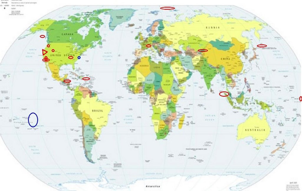
Places to watch.
(4 different California symptoms
but all in Southern California.)
Good luck to all.
For Wednesday, 2 August 2006.
----------------------------------------
Puerto Rico/Virgin Islands (Strong)
----------------------------------------
2.0 2006/08/02 23:51:44 18.935N -65.119W 16.8 68 km (42 mi) NNW of Charlotte Amalie, Saint Thomas, US Virgin Islands
2.4 2006/08/02 23:51:13 18.966N -65.111W 27.2 71 km (44 mi) NNW of Charlotte Amalie, Saint Thomas, US Virgin Islands
2.7 2006/08/02 23:45:06 18.962N -65.117W 28.2 70 km (44 mi) NNW of Charlotte Amalie, Saint Thomas, US Virgin Islands
3.3 2006/08/02 20:09:46 19.311N -65.292W 38.0 112 km (69 mi) N of Culebra, PR
1.4 2006/08/02 17:13:07 18.512N -64.568W 5.6 6 km ( 4 mi) N of East End-Long Look, Tortola, British Virgin Islands
3.3 2006/08/02 16:05:59 19.579N -64.519W 24.8 97 km (60 mi) NNW of Settlement, Anegada, British Virgin Islands
3.0 2006/08/02 09:52:53 19.070N -64.704W 4.9 55 km (34 mi) NW of Settlement, Anegada, British Virgin Islands
2.6 2006/08/02 09:50:17 18.797N -67.265W 15.8 38 km(24 mi) NNW of San Antonio, PR
2.6 2006/08/02 07:24:00 19.110N -66.481W 25.1 72 km (45 mi) N of Tierras Nuevas Poniente, PR
Santa Monica area (34.020 -118.463)
----------------------------------------
1.3 2006/08/01 08:23:10 33.633 -117.203 14.7 6 km ( 4 mi) ENE of Wildomar, CA
2.6 2006/08/02 16:05:30 33.734 -117.477 8.4 14 km ( 8 mi) WNW of Lake Elsinore, CA
Fillmore, California area (34.370 -118.980)
----------------------------------------
1.5 2006/08/02 13:48:16 34.697 -118.783 10.3 13 km ( 8 mi) SSE of Gorman, CA
1.1 2006/08/02 16:41:22 34.852 -118.761 0.0 10 km ( 7 mi) NE of Gorman, CA
1.1 2006/08/02 19:34:21 34.413 -118.356 0.0 14 km ( 9 mi) E of Santa Clarita, CA
The New Madrid Fault
----------------------------------------
1.3 2006/08/01 08:58:00 36.260N 89.500W 7.1 1 km ( 1 mi) WSW of Ridgely, TN
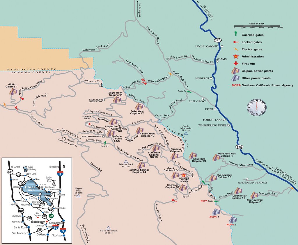
The Geysers (This is already at VERY STRONG
and I will leave it at that because I always
seem to get California symptoms overly strong.)
http://www.geysers.com/>geysers.com
----------------------------------------
1.4 2006/08/02 03:37:14 38.808 -122.795 2.2 2 km ( 1 mi) NE of The Geysers, CA
2.4 2006/08/02 09:13:04 38.765 -122.725 2.1 3 km(2 mi) WSW of Anderson Springs, CA
1.6 2006/08/03 08:02:44 38.814 -122.787 1.2 2 km ( 2 mi) NE of The Geysers, CA
2.1 2006/08/03 09:01:12 38.799 -122.799 4.3 1 km ( 0 mi) E of The Geysers, CA
2.0 2006/08/03 11:10:11 38.803 -122.782 3.6 2 km ( 1 mi) ENE of The Geysers, CA
1.3 2006/08/03 11:59:31 38.881 -122.522 9.9 8 km ( 5 mi) ESE of Lower Lake, CA
1.8 2006/08/03 17:07:25 38.818 -122.755 0.1 3 km ( 2 mi) SW of Cobb, CA
1.6 2006/08/03 23:09:01 38.796 -122.760 1.4 4 km ( 3 mi) E of The Geysers, CA
1.6 2006/08/03 23:40:44 38.828 -122.870 1.6 6 km ( 4 mi) WNW of The Geysers, CA
SOUTH PACIFIC OCEAN (3.6S 167.2E) then
possibly South Pacific Ocean (27.42S 125.67W)
----------------------------------------
(Nothing found for either area, I think I have the wrong area for the symptom.)
Switzerland area (46.19N 7.02E)
----------------------------------------
02Aug2006 17:46:28.0 46.3N 8.0E 2 ML=1.2 M SED Brig / Switzerland
02Aug2006 04:56:44.2 46.5N 7.5E 9 ML=1.4 M*SED Adelboden / Switzerland
Mt. St. Helen’s (Medium)
----------------------------------------
2.0 2006/08/01 01:59:34 46.197N 122.195W 0.0 1 km ( 1 mi) WSW of Mount St. Helens Volcano, WA
1.8 2006/08/01 07:01:55 46.195N 122.197W 0.0 1 km ( 1 mi) WSW of Mount St. Helens Volcano, WA
1.6 2006/08/01 10:13:36 46.197N 122.190W 0.0 1 km ( 1 mi) WSW of Mount St. Helens Volcano, WA
1.8 2006/08/01 13:40:58 46.196N 122.195W 0.7 1 km ( 1 mi) WSW of Mount St. Helens Volcano, WA
1.8 2006/08/01 21:17:23 46.196N 122.195W 0.7 1 km ( 1 mi) WSW of Mount St. Helens Volcano, WA
2.4 2006/08/02 11:57:19 46.203N 122.200W 0.0 2 km ( 1 mi) W of Mount St. Helens Volcano, WA
1.8 2006/08/02 12:26:25 46.199N 122.194W 0.5 1 km ( 1 mi) W of Mount St. Helens Volcano, WA
1.7 2006/08/03 00:01:59 46.195N 122.198W 0.2 2 km ( 1 mi) WSW of Mount St. Helens Volcano, WA
1.9 2006/08/03 22:44:16 46.197N 122.195W 0.9 1 km ( 1 mi) WSW of Mount St. Helens Volcano, WA
Kyrgyzstan area (40.64N 72.00E)
----------------------------------------
2006-08-01 00:34:27.0 41.14N 75.33E ML3.6 KYRGYZSTAN
Franz Josef Land (80.86 40.02)(STRONG)
----------------------------------------
FRANZ JOSEF LAND, RUSSIA
Origin time Lat Lon Azres Timres Wres Nphase Ntot Nsta Netmag
2006-213:10.37.32.0 82.34 43.17 9.13 4.49 6.77 3 3 2 2.19
FRANZ JOSEF LAND, RUSSIA
Origin time Lat Lon Azres Timres Wres Nphase Ntot Nsta Netmag
2006-213:16.01.53.0 80.65 56.88 11.60 3.91 6.81 3 6 2 2.07
FRANZ JOSEF LAND, RUSSIA
Origin time Lat Lon Azres Timres Wres Nphase Ntot Nsta Netmag
2006-213:16.22.21.0 80.54 43.69 11.15 0.69 3.48 3 3 3 2.20
FRANZ JOSEF LAND, RUSSIA
Origin time Lat Lon Azres Timres Wres Nphase Ntot Nsta Netmag
2006-213:19.06.36.0 79.95 50.53 5.90 0.77 2.24 4 5 3 2.12
Possibly Burnsville, North Carolina area
(35.895 -82.359) (Unproven symptom)
----------------------------------------
(Nothing found)
Devore, California (34.239 -117.450)
----------------------------------------
1.7 2006/08/01 13:51:26 34.139 -117.445 5.9 5 km ( 3 mi) NNE of Fontana, CA
1.6 2006/08/02 23:52:59 34.258 -117.028 6.7 9 km ( 6 mi) NE of Running Springs, CA
San Bernardino, California area
(34.107 -117.321)
----------------------------------------
3.3 2006/08/02 16:03:02 34.111 -117.316 16.0 3 km ( 2 mi) SW of San Bernardino, CA
2.4 2006/08/02 16:05:30 33.730 -117.487 10.3 14 km ( 9 mi) NE of Rancho Santa
Margarita, CA
Honduras area (13.59N 86.78W)
----------------------------------------
06/08/02 22:39:37 12.88N 88.95W 13.9 3.8ML Frente a El Salvador
06/08/02 12:39:52 12.22N 87.14W 88.4 3.6ML Frente a Poneloya
06/08/02 03:39:05 12.64N 87.08W 143.6 2.8ML Cerca del Volcan San Cristóba
Utah
----------------------------------------
1.2 2006/08/02 01:33:35 39.614 -110.391 1.0 7 km ( 4 mi) N of Sunnyside, UT
1.5 2006/08/02 10:31:41 39.613 -110.401 1.7 7 km ( 4 mi) N of Sunnyside, UT
1.5 2006/08/02 11:01:02 37.361 -113.464 1.4 16 km ( 10 mi) NW of Leeds, UT
1.5 2006/08/02 12:26:19 39.616 -110.398 1.5 7 km ( 4 mi) N of Sunnyside, UT
Gulf of Alaska (59.139 -145.990)
(MEDIUM)
----------------------------------------
3.8 2006/08/02 19:01:17 53.044 -160.769 15.0 SOUTH OF ALASKA
Kuril Islands area (52.45N 154.72E)
(Strong)
----------------------------------------
2006-08-01 02:04:27.4 46.16N 147.02E 33 mb4.1 NW. KURIL ISLANDS, RUSSIA
2006-08-01 15:28:35.7 47.97N 151.38E 112 mb4.6 KURIL ISLANDS, RUSSIA
Northern Sumatra area (1.31N 97.09E)
(Strong)
----------------------------------------
2006-08-02 13:11:55.1 8.76N 91.94E 10 mb5.1 NICOBAR ISLANDS, INDIA, REG
2006-08-02 18:13:57.8 4.02N 96.00E 40 mb5.2 NORTHERN SUMATERA, INDONESIA
Peace to all.

posted by Unknown @ 2:15 PM
0 comments
![]()
![]()
