*For Friday, 12 May 2006.
LEGEND for OVERVIEW: Size = My surety of area for quake.
Red Circle = Probable quake to STRONG quake.
Triangle = Very Strong or Stronger quake (And usually takes extra days).
Blue Circle, etc. = Uncertainty of symptom area for probable quake.
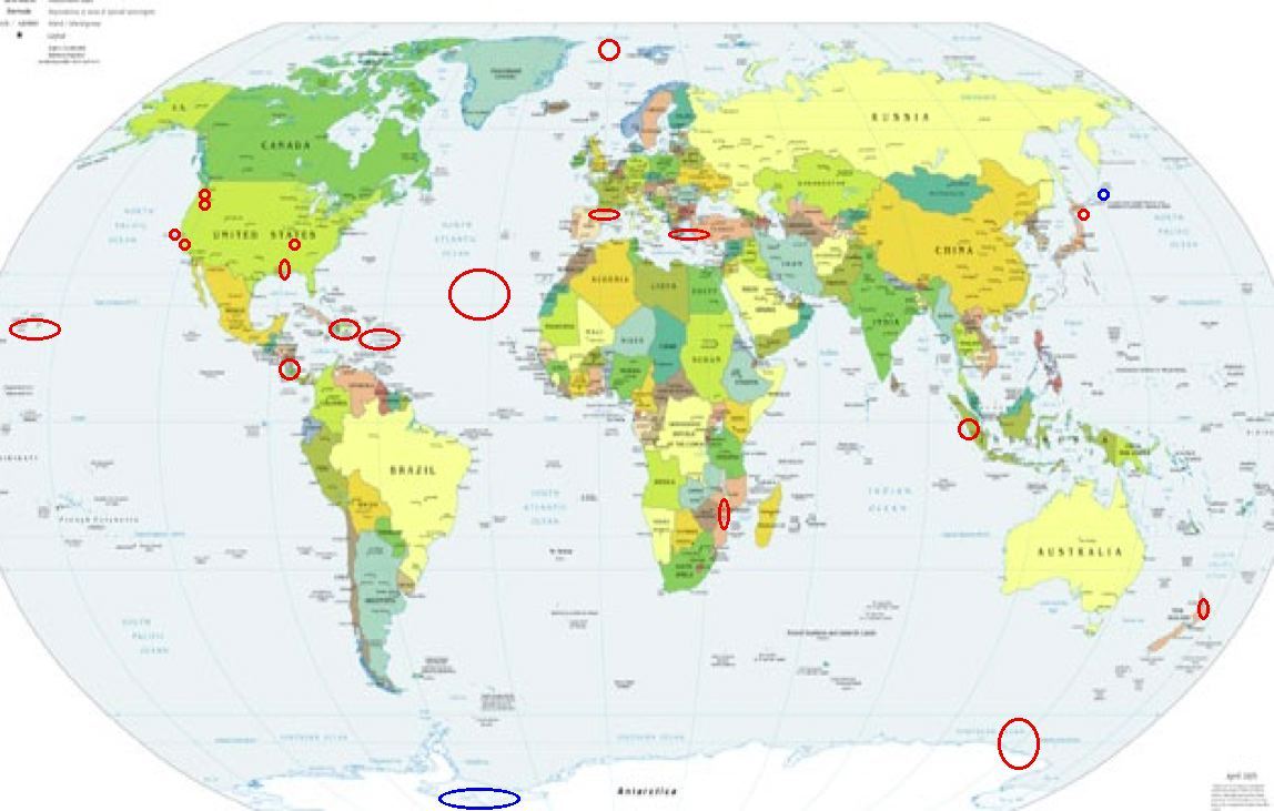
Places to watch.
Good luck to all.
For Friday, 12 May 2006.
----------------------------------------
Possibly The Kurils or Antarctica (Non-proven symptom)
----------------------------------------
2006-05-12 17:27:25 5.0 55.46 N 161.35 E Near East Coast of Kamchatka
San Francisco Bay
----------------------------------------
MAP 1.3 2006/05/12 08:31:52 37.791 -122.222 9.5 1 km ( 0 mi) SE of Oakland, CA
Pyrenees at France-Spain border (Strong)
----------------------------------------
2006-05-12 10:50:35.0 47.02 N 1.25 W 2 ML 2.9 FRANCE
Mt. St. Helen’s (Strong)
----------------------------------------
MAP 1.4 2006/05/12 00:06:17 46.193 -122.196 1.0 1 km ( 1 mi) WSW of Mount St. Helens Volcano, WA
MAP 1.6 2006/05/12 07:44:14 46.196 -122.195 0.8 1 km ( 1 mi) WSW of Mount St. Helens Volcano, WA
http://news.yahoo.com/s/ap/20060512/ap_on_sc/mount_st__helens_1
map 1.6 2006/05/12 16:23:30 46.197N 122.195W 0.9 1 km ( 1 mi) WSW of Mount St. Helens Volcano, WA
map 1.6 2006/05/12 07:15:12 46.197N 122.194W 0.9 1 km ( 1 mi) WSW of Mount St. Helens Volcano, WA
Central area of North Atlantic (Non-specific but indication of depth - STRONG)
----------------------------------------
2006-05-08 04:54:46 4.6 34.89 N 35.79 W Northern Mid Atlantic Ridge.
Possibly Pacific-Antarctic Ridge (-54.973 -127.196) (This is a non-proven symptom but the indication of depth should prove it this time - STRONG)
----------------------------------------
(Posted a South Sandwich quake on the 13th list.)
North Island of New Zealand (-38.190 176.250)
----------------------------------------
Reference Number: 2567254/G
Universal Time: May 13 2006 at 6:27
NZ Standard Time: Saturday, May 13 2006 at 6:27 pm
Latitude, Longitude: 37.78°S, 176.81°E
Focal Depth: 5 km
Richter Magnitude: 3.3
10 km north-east of Matata
20 km north of Edgecumbe
30 km north-west of Whakatane
210 km south-east of Auckland
Felt in Whakatane.
Costa Rica/Nicaragua area (Volcanic - Strong)
----------------------------------------
06/05/12 13:48:17 10.41N 86.61W 1.0 2.9ML Oceano Pacífico de Nicaragua
06/05/12 12:43:10 12.56N 87.43W 90.6 3.4ML Frente al Cosigüina
06/05/12 06:04:45 13.18N 89.92W 19.9 3.2ML Frente a El Salvador
06/05/12 02:37:32 13.42N 86.93W 15.0 2.1ML Honduras
06/05/12 01:59:23 12.38N 87.65W 46.9 2.2ML Frente al Cosigüina
06/05/12 01:56:00 12.10N 87.81W 21.1 2.3ML Oceano Pacífico de Nicaragua
Svalbard/Norwegian Sea area (Strong)
----------------------------------------
NORDAUSTLANDET SVALBARD
Origin time Lat Lon Azres Timres Wres Nphase Ntot Nsta Netmag
2006-131:04.07.33.0 80.54 25.47 10.35 0.17 2.76 2 2 1 2.14
Hokkaido
----------------------------------------
2006-05-11 16:09:41 5.6 43.11 N 145.80 E Hokkaido, Japan Region
2006-05-11 16:09:44 5.6 43.22 N 145.60 E Hokkaido, Japan Region
Sumatra (STRONG)
----------------------------------------
2006-05-12 01:58:44.2 11.37 S 115.85 E 2 mb 5.0 SOUTH OF BALI, INDONESIA
2006-05-12 08:16:56.5 5.60 S 105.51 E 25 f mb 5.6 SUNDA STRAIT, INDONESIA
2006-05-12 20:15:21 5.4 3.71 N 126.75 E Talaud Islands, Indonesia
2006-05-13 03:11:35.7 5.66 N 94.38 E mb 6.0 NORTHERN SUMATERA, INDONESIA
2006-05-13 05:43:47.8 5.41 N 95.88 E 151 mb 4.5 NORTHERN SUMATERA, INDONESIA
Mozambique
----------------------------------------
2006-05-12 18:12:19 5.1 21.28 S 33.18 E Mozambique
2006-05-15 13:56:09.9 21.42 S 33.28 E 10 mb 5.5 MOZAMBIQUE
(3-4 extra days)
The Virgin Islands/Puerto Rico area and then Dominican Republic/Haiti area (3 different symptoms - STRONG)
----------------------------------------
MAP 3.2 2006/05/12 06:53:09 19.120 -64.668 35.0 57 km ( 35 mi) NW of Settlement, British Virgin Islands
MAP 3.2 2006/05/12 12:48:03 18.517 -66.601 102.6 8 km ( 5 mi) NNW of Garrochales, PR
MAP 3.3 2006/05/12 13:47:16 19.102 -66.445 28.2 71 km ( 44 mi) N of Breñas, PR
MAP 2.7 2006/05/12 15:39:02 18.977 -66.405 59.2 57 km ( 35 mi) N of Breñas, PR
MAP 2.7 2006/05/12 15:38:08 18.997 -66.429 9.1 59 km ( 37 mi) N of Breñas, PR
MAP 2.9 2006/05/12 15:35:49 19.092 -66.436 25.2 70 km ( 43 mi) N of Breñas, PR
Hawaii
----------------------------------------
MAP 2.8 2006/05/12 15:47:23 19.402 -155.284 20.1 7 km ( 5 mi) SW of Volcano, HI
MAP 1.9 2006/05/12 20:38:02 19.089 -155.121 52.9 40 km ( 25 mi) ESE of Pahala, HI
MAP 1.9 2006/05/12 22:03:04 19.384 -155.286 2.6 9 km ( 6 mi) SW of Volcano, HI
MAP 1.7 2006/05/12 22:01:58 19.382 -155.286 2.2 9 km ( 6 mi) SW of Volcano, HI
MAP 1.8 2006/05/12 22:01:11 19.382 -155.287 2.2 9 km ( 6 mi) SW of Volcano, HI
The New Madrid Fault/Mississippi-Louisiana border area then Ridgely, TN area (36.290 -89.420) (Something strange for the Mississippi-Louisiana border area - 2 strong spikes of pain and then a coldness that lingered. Strong.)
----------------------------------------
MAP 2.1 2006/05/11 16:28:45 36.160 -89.440 10.2 12 km ( 8 mi) SSE of Ridgely, TN
MAP 2.2 2006/05/11 22:12:30 37.986 -90.496 6.6 9 km ( 5 mi) NE of Bonne Terre, MO
MAP 2.8 2006/05/12 01:51:11 40.740 -84.080 5.0 3 km ( 2 mi) E of Lima, OH
(Not sure this should be here - also posting it on the 14th)
Klamath Falls, Oregon area (42.232 -121.910)
----------------------------------------
(Nothing found)
Greece/Turkey area
----------------------------------------
2006-05-12 01:53:09.4 37.93 N 27.31 E 30 MD 2.8 TURKEY
2006-05-12 06:24:10.4 41.90 N 26.80 E 11 MD 3.1 GREECE-BULGARIA BORDER REGION
2006-05-12 04:36:43.8 38.44 N 40.96 E 36 MD 3.3 TURKEY
2006-05-12 08:17:11.9 42.24 N 34.50 E 27 MD 3.1 BLACK SEA
2006-05-12 22:44:17.0 37.02 N 28.04 E ML 3.2 TURKEY
2006-05-12 21:17:59.1 35.31 N 26.78 E 60 mb 3.9 CRETE, GREECE
2006-05-12 21:15:20.7 39.92 N 38.88 E 9 MD 3.4 TURKEY
2006-05-12 20:59:42.2 35.02 N 26.92 E 60 mb 4.1 CRETE, GREECE
Coso Junction (Medium)
----------------------------------------
MAP 2.2 2006/05/15 04:41:19 36.027 -117.905 5.4 4 km ( 3 mi) ESE of Coso Junction, CA
(3 extra days)
Peace to all.

posted by Unknown @ 2:32 PM
0 comments
![]()
![]()
