*For Wednesday, 8 March 2006.
LEGEND for OVERVIEW:
Size = My surety of area for quake.
Red Circle = Probable quake to STRONG quake.
Triangle = Very Strong or Stronger quake (And usually takes extra days).
Blue Circle, etc. = Uncertainty of symptom area for probable quake.
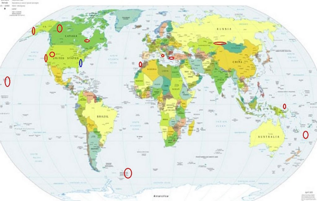
Places to watch.
Good luck to all.
For Wednesday, 8 March 2006.
----------------------------------------
James Bay, Canada area (53.51N 81.86W) (Second day symptom - Strong)
----------------------------------------
2006/03/08 01:38:27 47.57N 78.24W 18.0g 2.1MN GSC 63 km S from Malartic, QC
2006/03/09 10:55:39 52.85N 80.40W 18.0g 1.5MN GSC James Bay
2006/03/09 01:29:14 45.95N 77.61W 18.0g 1.9MN GSC 19 km SW from Deep River, ON
Hawaii and South of (Strong)
----------------------------------------
MAP 1.9 2006/03/08 18:52:09 19.296 -155.210 7.9 17 km ( 11 mi) S of Volcano, HI
Southwestern Alaska Coast
----------------------------------------
MAP 2.6 2006/03/08 16:04:42 61.700 -149.789 35.0 SOUTHERN ALASKA
South Sandwich Islands (60.99 S 25.24 W)
----------------------------------------
2006-03-09 09:59:57 5.6 59.54 S 29.70 W South Sandwich Islands Region
2006-03-10 10:12:20 6.1 60.35 S 46.54 W Scotia Sea
(2 days late)
Parkfield Fault (Medium)
----------------------------------------
MAP 1.6 2006/03/08 22:08:10 36.536 -121.066 7.4 7 km ( 4 mi) E of Pinnacles, CA
MAP 2.6 2006/03/08 22:01:52 37.373 -121.629 6.9 17 km ( 11 mi) E of Alum Rock, CA
MAP 1.5 2006/03/08 21:45:45 36.817 -121.539 5.8 3 km ( 2 mi) S of San Juan Bautista, CA
MAP 1.3 2006/03/08 20:29:58 36.536 -121.124 2.5 2 km ( 1 mi) ENE of Pinnacles, CA
MAP 2.1 2006/03/08 13:15:28 36.559 -121.148 5.6 3 km ( 2 mi) N of Pinnacles, CA
AP 1.1 2006/03/08 11:58:55 36.126 -120.564 1.8 19 km ( 12 mi) W of Coalinga, CA
MAP 2.3 2006/03/08 11:06:58 36.559 -121.148 5.5 3 km ( 2 mi) N of Pinnacles, CA
MAP 1.3 2006/03/08 10:38:04 36.559 -121.148 5.6 3 km ( 2 mi) N of Pinnacles, CA
MAP 2.1 2006/03/08 09:18:50 35.929 -120.479 5.1 5 km ( 3 mi) NW of Parkfield, CA
MAP 1.5 2006/03/08 05:40:01 36.559 -121.162 0.0 3 km ( 2 mi) NNW of Pinnacles, CA
MAP 1.6 2006/03/08 03:04:23 36.557 -121.147 5.4 3 km ( 2 mi) N of Pinnacles, CA
MAP 1.7 2006/03/08 02:17:06 36.562 -121.148 5.8 3 km ( 2 mi) N of Pinnacles, CA
MAP 2.8 2006/03/08 02:12:21 36.561 -121.144 3.7 3 km ( 2 mi) N of Pinnacles, CA
MAP 3.0 2006/03/08 02:11:00 36.561 -121.146 5.4 3 km ( 2 mi) N of Pinnacles, CA
MAP 2.4 2006/03/08 00:41:33 36.561 -121.146 5.3 3 km ( 2 mi) N of Pinnacles, CA
Northwest Territories, Canada (64.932 -129.261) (Medium)
----------------------------------------
2006/03/07 01:09:14 64.91N 129.41W 10F 2.7 134 km WSW Norman Wells NT
Mongolia/Kazakhstan border region
----------------------------------------
2006-03-07 18:53:03.0 50.68N 91.27E ML3.0 TUVA-BURYATIA-MONGOLIA BDR REG
West of Gibraltar area (35.53N 9.58W) (Strong)
----------------------------------------
2006-03-08 02:32:31.5 35.32 N 4.55 W 30 f ML 3.0 STRAIT OF GIBRALTAR
Possibly North Carolina Coast (New Symptom)
----------------------------------------
MAP 2.8 2006/03/06 10:28:02 35.895 -82.359 0.0 6 km ( 4 mi) WSW of Burnsville, NC
(2 days early)
Greece/Turkey area
----------------------------------------
2006-03-07 06:11:29.6 40.82N 27.74E 12 MD2.7 TURKEY
2006-03-07 13:12:35.7 37.55N 38.76E 3 MD3.1 TURKEY
2006-03-08 00:41:31.0 36.67N 21.07E ML3.0 SOUTHERN GREECE
2006-03-08 04:09:46.7 38.28N 38.70E 5 MD3.0 TURKEY
2006-03-08 04:04:38.1 38.48N 39.23E 18 MD3.4 TURKEY
2006-03-08 04:18:57.2 40.98N 20.48E 2 ML3.8 GREECE-ALBANIA BORDER REGION
2006-03-08 07:03:16.8 40.70N 29.23E 16 MD2.6 TURKEY
2006-03-08 14:31:48.5 41.81N 35.44E 32 MD2.9 TURKEY
2006-03-08 14:24:33.6 37.81N 27.33E 25 MD3.0 TURKEY
Southern Italy
----------------------------------------
2006-03-08 05:38:55.0 42.99 N 12.87 E 5 ML 2.5 CENTRAL ITALY
2006-03-08 14:05:51.0 38.60 N 12.92 E 30 ML 3.1 SICILY, ITALY
Western Caroline Islands (8.66 N 138.33 E)
----------------------------------------
(Nothing found)
Utah/Nevada (Medium)
----------------------------------------
MAP 1.6 2006/03/08 02:51:30 39.412 -111.217 6.5 23 km ( 15 mi) WNW of Huntington, UT
MAP 1.7 2006/03/08 04:15:23 39.410 -111.213 2.4 23 km ( 14 mi) WNW of Huntington, UT
MAP 1.3 2006/03/08 05:21:58 39.410 -111.217 2.9 23 km ( 15 mi) WNW of Huntington, UT
MAP 1.4 2006/03/08 07:18:48 39.668 -110.512 4.7 16 km ( 10 mi) NW of Sunnyside, UT
MAP 1.3 2006/03/08 13:23:13 38.186 -112.676 5.2 11 km ( 7 mi) SSW of Beaver, UT
MAP 1.2 2006/03/08 15:11:25 39.728 -110.740 1.0 11 km ( 7 mi) ENE of Helper, UT
MAP 1.6 2006/03/08 21:12:58 39.490 -119.624 0.0 12 km ( 7 mi) SE of Sparks, NV
South of Fiji
----------------------------------------
2006-03-08 12:28:46.7 16.47S 177.51W 400f mb4.8 FIJI ISLANDS REGION
Peace to all.

posted by Unknown @ 3:51 PM
0 comments
![]()
![]()
