*For Friday, 14 April 2006.
LEGEND for OVERVIEW: Size = My surety of area for quake.
Red Circle = Probable quake to STRONG quake.
Triangle = Very Strong or Stronger quake (And usually takes extra days).
Blue Circle, etc. = Uncertainty of symptom area for probable quake.
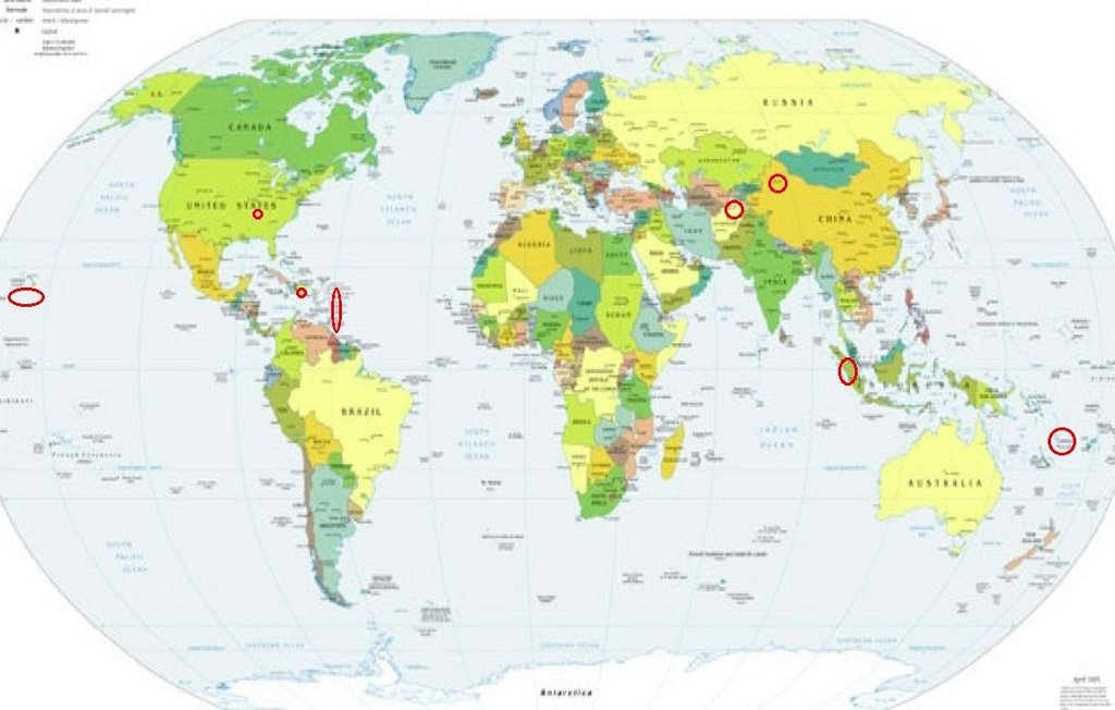
Places to watch.
Good luck to all.
For Friday, 14 April 2006.
----------------------------------------
Xinjiang, China area (41.42N 83.04E) (medium)
----------------------------------------
2006-04-14 09:27:38.7 35.33N 89.71E 15 mb5.6 XIZANG
Hawaii area (Medium)
----------------------------------------
MAP 2.0 2006/04/14 06:02:50 19.736 -155.837 0.9 18 km ( 11 mi) E of Kalaoa, HI
MAP 2.4 2006/04/14 09:04:53 19.337 -155.129 5.5 15 km ( 9 mi) S of Fern Forest, HI
MAP 2.4 2006/04/14 21:44:20 20.063 -156.143 11.0 32 km ( 20 mi) WNW of Puako, HI
Afghanistan/Tajikistan border area (37.51N 69.11E) (STRONG)
----------------------------------------
2006-04-15 13:59:08.0 39.33N 67.25E ML3.2 SOUTHEASTERN UZBEKISTAN
E of Higüey, Dominican Republic (18.575 -67.990 ) (STRONG)
----------------------------------------
MAP 2.9 2006/04/14 02:46:01 19.077 -66.455 5.2 68 km ( 43 mi) N of Tierras Nuevas Poniente, PR
MAP 3.3 2006/04/14 04:54:32 17.383 -67.953 12.1 104 km ( 65 mi) SW of Pole Ojea, PR
Vanuatu (14.86S 167.90E) (STRONG)
----------------------------------------
2006-04-17 23:49:56 5.6 12.47 S 166.49 E Santa Cruz Islands
(3 extra days)
2006-04-18 13:40:56 5.3 17.61 S 168.32 E Vanuatu Islands
2006-04-18 20:03:06 5.3 12.28 S 167.72 E Santa Cruz Islands
(4 extra days)
The Virgin Islands area (Medium)
----------------------------------------
MAP 2.5 2006/04/13 05:30:44 18.738 -64.383 42.6 7 km ( 4 mi) W of Settlement, British Virgin Islands
MAP 3.7 2006/04/13 12:32:00 19.107 -64.381 47.2 42 km ( 26 mi) N of Settlement, British Virgin Islands
MAP 3.8 2006/04/13 12:21:39 19.023 -64.302 63.7 33 km ( 20 mi) N of Settlement, British Virgin Islands
MAP 2.7 2006/04/13 12:59:40 19.029 -64.367 58.1 34 km ( 21 mi) N of Settlement, British Virgin Islands
MAP 2.7 2006/04/13 12:45:41 19.197 -64.501 16.9 55 km ( 34 mi) NNW of Settlement, British Virgin Islands
MAP 2.3 2006/04/13 13:02:21 19.059 -64.599 1.4 47 km ( 29 mi) NW of Settlement, British Virgin Islands
MAP 2.5 2006/04/13 15:11:25 19.063 -64.314 58.3 37 km ( 23 mi) N of Settlement, British Virgin Islands
MAP 2.5 2006/04/13 15:08:04 18.967 -64.316 63.1 26 km ( 16 mi) N of Settlement, British Virgin Islands
MAP 3.8 2006/04/13 14:55:22 19.121 -64.359 51.3 44 km ( 27 mi) N of Settlement, British Virgin Islands
MAP 2.8 2006/04/13 16:00:29 19.077 -64.304 59.2 39 km ( 24 mi) N of Settlement, British Virgin Islands
The New Madrid Fault
----------------------------------------
MAP1.5 2006/04/14 10:19:01 36.490 -89.550 8.6 6 km ( 4 mi) ESE of Marston, MO
Sumatra
----------------------------------------
MAP 4.9 2006/04/14 10:26:10 9.526 93.063 38.1 NICOBAR ISLANDS, INDIA REGION
Peace to all.

posted by Unknown @ 6:21 PM
0 comments
![]()
![]()
