*For Monday, 30 January 2006.
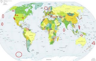
LEGEND for OVERVIEW:
Size = My surety of area for quake.
Red Circle = Probable quake to STRONG quake.
Triangle = Very Strong or Stronger quake (And usually takes extra days).
Blue Circle, etc. = Uncertainty of symptom area for probable quake.

Places to watch.
Good luck to all.
For Monday, 30 January 2006.
----------------------------------------
Arafura Sea/Darwin, Australia area (Might have something to do with Tropical Cyclone Daryl.)
----------------------------------------
MAP 4.4 2006/01/29 23:19:10 2.121 124.834 255.4 CELEBES SEA
(North of where I thought.)
Wyoming (Medium)
----------------------------------------
map 2.2 2006/01/30 22:00:39 44.090 -110.531 5.5 53 km ( 33 mi) NE of Alta, WY
Bulgaria
----------------------------------------
2006-01-30 20:12:49.5 46.00N 27.66E 25 ML3.7 ROMANIA
(Just a little more North)
Gulf of Alaska
----------------------------------------
map 3.7 2006/01/31 02:39:29 58.704 -141.371 15.0 OFF THE COAST OF SOUTHEASTERN ALASKA
Noregian Sea/Norway
----------------------------------------
SVALBARD, NORWAY, REGION
Origin time Lat Lon Azres Timres Wres Nphase Ntot Nsta Netmag
2006-029:19.01.57.0 79.16 7.75 5.23 2.35 3.66 3 4 2 2.35
TROMS NORWAY
Origin time Lat Lon Azres Timres Wres Nphase Ntot Nsta Netmag
2006-029:19.51.24.0 70.09 18.28 3.39 1.98 2.83 3 7 1 2.22
OPPLAND-HEDMARK NORWAY
Origin time Lat Lon Azres Timres Wres Nphase Ntot Nsta Netmag
2006-030:00.19.44.0 62.58 9.28 1.60 0.11 0.51 2 3 1 3.22
ROGALAND NORWAY
Origin time Lat Lon Azres Timres Wres Nphase Ntot Nsta Netmag
2006-030:00.20.04.0 59.35 6.40 1.25 0.23 0.55 2 2 1 2.71
SVALBARD, NORWAY, REGION
Origin time Lat Lon Azres Timres Wres Nphase Ntot Nsta Netmag
2006-030:01.40.14.0 81.72 9.44 12.55 0.14 3.27 2 2 1 2.79
Carlsberg Ridge area (0.3S 65.0E)
----------------------------------------
2006-01-30 07:31:07.3 11.68N 43.44E 9 ML3.3 ETHIOPIA
2006-01-30 14:19:09.4 11.49N 43.44E 6 ML3.2 ETHIOPIA
2006-01-30 17:26:16.4 12.19N 44.56E 18 ML2.7 WESTERN ARABIAN PENINSULA
(I seem to have this symptom wrong - I will try to watch for a repeat.)
Pacific-Antarctic Ridge (55.22S 135.58W) (Strong)
----------------------------------------
2006-01-30 21:24:22.7 49.12S 115.93E 10 mb5.3 SOUTH OF AUSTRALIA
(I am not sure of this symptom but this is somewhat near my interpretation.)
Southwest of Aleutian Islands
----------------------------------------
map 3.6 2006/01/30 03:33:42 51.100 -179.159 15.0 ANDREANOF ISLANDS, ALEUTIAN IS., ALASKA
map 3.6 2006/01/30 18:18:22 51.459 178.685 1.3 RAT ISLANDS, ALEUTIAN ISLANDS, ALASKA
Joshua Tree, California (34.011 -116.323)
----------------------------------------
map 1.2 2006/01/30 03:28:47 33.693 -116.815 20.6 10 km ( 6 mi) SE of Valle Vista, CA
map 1.5 2006/01/30 06:42:00 33.489 -116.470 16.5 20 km ( 12 mi) ESE of Anza, CA
map 1.4 2006/01/30 12:25:18 33.304 -116.349 12.7 7 km ( 4 mi) NNE of Borrego Springs, CA
map 2.7 2006/01/30 12:47:15 33.505 -116.474 3.2 19 km ( 12 mi) ESE of Anza, CA
map 1.2 2006/01/30 12:51:15 33.297 -116.289 11.4 10 km ( 6 mi) NE of Borrego Springs, CA
map 1.8 2006/01/30 12:56:55 33.470 -116.437 7.7 24 km ( 15 mi) ESE of Anza, CA
map 1.4 2006/01/30 13:02:10 33.505 -116.458 8.6 21 km ( 13 mi) ESE of Anza, CA
Pinnacles/Parkfield
----------------------------------------
map 1.1 2006/01/30 06:49:33 35.998 -120.566 3.9 16 km ( 10 mi) NW of Parkfield, CA
Mt. St. Helen's then Mt. Hood area (STRONG for Mt. St. Helen's)
----------------------------------------
map 2.7 2006/01/29 05:28:18 46.192N 122.189W 0.0 1 km ( 0 mi) SSE of Mount St. Helens
MAP 3.1 2006/01/31 10:17:36 46.201 -122.190 0.0 1 km ( 0 mi) W of Mount St. Helens Volcano, WA
Cambria, California (35.589 -120.979)
----------------------------------------
map 1.8 2006/01/30 07:36:42 36.166 -120.733 7.9 22 km ( 14 mi) NE of San Ardo, CA
Kermadec Islands (Very Stong)
http://www.nationalgeographic.com/wildworld/profiles/terrestrial/oc/oc0107.html>Kermadec Islands

----------------------------------------
2006-01-30 02:10:33 5.3 31.91S 178.76W Kermadec Islands Region
Mongolia
----------------------------------------
2006-01-29 18:31:25.0 50.58N 91.19E ML3.9 TUVA-BURYATIA-MONGOLIA BDR REG
Kukuihaele, Hawaii area (20.329 -155.465) (Strong)
----------------------------------------
map 1.8 2006/01/30 21:43:20 19.401N 155.265W 2.2 2 km ( 1 mi) SSE of Kilauea Summit
map 1.7 2006/01/30 21:34:27 19.334N 155.199W 6.2 9 km ( 6 mi) NW of Ka`ena Point
map 2.3 2006/01/30 19:57:45 19.749N 156.052W 14.2 13 km ( 8 mi) NNW of Kailua
map 1.7 2006/01/30 14:25:05 19.373N 155.431W 9.2 17 km (11 mi) WSW of Kilauea Summit
map 1.8 2006/01/30 12:38:10 19.335N 155.111W 5.8 6 km ( 4 mi) S of Pu`u `O`o Crater
map 2.3 2006/01/30 09:36:57 19.391N 155.247W 3.6 4 km ( 3 mi) SE of Kilauea Summit
map 2.9 2006/01/30 07:35:19 19.396N 155.252W 3.0 3 km ( 2 mi) SE of Kilauea Summit
map 1.8 2006/01/30 00:55:51 19.398N 155.254W 3.1 3 km ( 2 mi) SE of Kilauea Summit
map 2.2 2006/01/30 00:13:31 19.390N 155.248W 3.2 4 km ( 3 mi) SE of Kilauea Summit
Luzon, Philippines area (15.88 N 120.66 E)
----------------------------------------
29Jan2006 00:03:17.2 6.7N 125.6E150 mb=4.7 M*GSR MINDANAO, PHILIPPINE ISLAN0638
New Madrid Fault
----------------------------------------
map 1.7 2006/01/31 14:33:13 35.800 -90.120 15.9 7 km ( 5 mi) NW of Victoria, AR
Poland
----------------------------------------
2006-01-30 17:24:44.2 51.30N 15.98E 10 ML2.2 POLAND
Northern Italy/Austria area (Medium)
----------------------------------------
(Nothing found)
Peace to all.

