*For Friday, 4 August 2006.
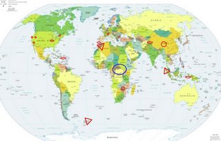
LEGEND for OVERVIEW: Size = My surety of area for quake.
Red Circle = Probable quake to STRONG quake.
Triangle = Very Strong/Stronger quake (Usually takes extra days).
Blue Circle, etc. = Uncertainty of symptom area for probable quake.

Places to watch.
Good luck to all.
For Friday, 4 August 2006.
----------------------------------------
Ludlow California area (34.844 -116.409)
----------------------------------------
1.1 2006/08/04 02:01:59 34.569 -116.279 11.5 20 km ( 13 mi) SSW of Ludlow, CA
1.2 2006/08/04 03:09:17 33.427 -116.370 15.5 20 km (12 mi) N of Borrego Springs, CA
1.2 2006/08/04 04:07:07 33.218 -116.011 1.5 10 km ( 6 mi) SSW of Salton City, CA
1.4 2006/08/04 05:16:52 33.649 -116.774 15.4 12 km ( 7 mi) SSW of Idyllwild, CA
2.2 2006/08/04 08:24:41 33.461 -116.412 7.1 24 km ( 15 mi) N of Borrego Springs, CA
1.4 2006/08/04 15:50:33 33.237 -116.091 8.3 11 km ( 7 mi) NNE of Ocotillo Wells, CA
1.8 2006/08/04 15:45:59 33.247 -116.130 4.3 12 km ( 7 mi) N of Ocotillo Wells, CA
1.6 2006/08/04 18:19:37 33.475 -116.522 16.8 16 km ( 10 mi) ESE of Anza, CA
1.4 2006/08/04 21:38:42 33.535 -116.498 16.8 16 km ( 10 mi) E of Anza, CA
Switzerland (46.19N 7.02E)
----------------------------------------
03Aug2006 00:14:00.5 46.2N 7.7E 2 ML=1.2 M*SED St. Niklaus / Switzerland ----
Morocco area (34.99N 2.90W)
(Second day of symptoms - Extremely Strong)
http://www.packyourbags.com/holidays-to-morocco.php

----------------------------------------
(Nothing found)
Qinghai, China (33.31N 96.04E) then Mongolia
(Medium for China)
----------------------------------------
2006-08-05 07:33:22.3 30.90N 80.10E 149 mb4.7 WESTERN XIZANG-INDIA BDR REG
Strait of Gibraltar area (Medium)
----------------------------------------
2006-08-03 16:11:48.2 39.53N 12.65W 30 mb3.0 NORTH ATLANTIC OCEAN
South Sandwich Islands (55.79S 27.54W)
(This was Hard - Very Strong)
http://www.oceanexplorer.net/south-georgia-maps/south-georgia-cruises.htm

----------------------------------------
2006-08-03 17:28:03 5.7 57.67S 25.49W 20 km South Sandwich Islands Region
Possibly Central Africa/Uganda area
(Unproven symptom)
----------------------------------------
2006-08-03 14:49:56.7 13.81N 42.76E 7 ML4.1 ETHIOPIA
Zimbabwe area (20.97S 32.89E)
----------------------------------------
(Came in on the 3d and posted there.)
Loyalton, California area (39.565 -120.371)
(Medium)
----------------------------------------
2.0 2006/08/04 08:18:53 39.460 -123.096 11.5 13 km (8 mi)WNW of Lake Pillsbury, CA?
Puerto Rico/Virgin Islands
----------------------------------------
2.1 2006/08/03 18:21:24 18.198N -67.131W 21.5 1 km ( 1 mi) ESE of Mayagüez, PR
1.6 2006/08/03 09:22:57 18.068N -65.733W 4.9 11 km ( 7 mi) SSE of Punta Santiago, PR
2.8 2006/08/03 00:18:24 18.968N -65.105W 24.5 71 km (44 mi) NNW of Charlotte Amalie, Saint Thomas, US Virgin Islands
3.3 2006/08/04 23:07:41 18.370N -68.522W 91.4 34 km (21 mi) SE of Higüey, La Altagracia, Dominican Republic
3.6 2006/08/04 14:28:17 18.155N -67.793W 179.2 61 km (38 mi) WSW of Stella, PR
2.7 2006/08/04 05:22:25 19.023N -64.873W 0.0 67 km (41 mi) WNW of Settlement, Anegada, British Virgin Islands
2.5 2006/08/04 05:05:33 18.771N -65.394W 53.9 53 km (33 mi) N of Culebra, PR
Northern Sumatra (5.21N 94.24E)
(A not-so-big charley horse - Very Strong)
http://www.pactoltd.com/hotspotdetail.asp?CategoryID=1000138

----------------------------------------
2006-08-04 10:47:40.9 5.37N 94.57E 40 mb5.1 NORTHERN SUMATERA, INDONESIA
Petrolia (Medium)
----------------------------------------
2.5 2006/08/05 03:57:40 40.600 -123.283 31.3 12 km ( 7 mi) WNW of Hayfork, CA
2.7 2006/08/09 18:05:20 40.312 -124.543 22.4 22 km ( 14 mi) W of Petrolia, CA
(5 extra days - or missed the symptom for this one.)
Timor Region area (8.54S 125.80E)
----------------------------------------
2006-08-03 00:03:10.7 0.11S 125.37E 90 mb5.0 NORTHERN MOLUCCA SEA
The New Madrid Fault/probably Tennessee
----------------------------------------
1.6 2006/08/04 04:46:03 36.370N 89.580W 10.2 10 km ( 6 mi) W of Tiptonville, TN
Lake Erie/New York area
----------------------------------------
(Nothing found)
Hindu Kush area (Indication of depth and volcanic)
----------------------------------------
2006-08-02 21:17:24.6 39.39N 71.36E 80 mb4.1 TAJIKISTAN
2006-08-03 05:53:06.0 38.44N 73.52E 180 mb4.5 TAJIKISTAN-XINJIANG BORDER REG
2006-08-03 09:51:46 4.8 36.66N 70.87E Hindu Kush Region, Afghanistan
Peace to all.

