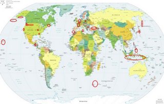
*For Sunday, 28 January 2007.
LEGEND for OVERVIEW: Size = My surety of area for quake.
Red Circle = Probable quake to STRONG quake.
Triangle = Very Strong/Stronger quake (Usually takes extra days).
Blue Circle, etc. = Uncertainty of symptom area for probable quake.

Places to watch.
Good luck to all.
For Sunday, 28 January 2007.
--------------------------------------
The Aleutians and south of
(Medium)
--------------------------------------
(Nothing found)
Belgium/Germany area
then Poland
--------------------------------------
2007-01-28 02:18:24.7 51.55N 16.02E 4 ML3.0 POLAND
2007-01-28 10:32:37 2.6ML 50.91N 12.71E 10 Germany
Mt. Etna/Sicily (Felt volcanic - Strong)
--------------------------------------
(Nothing found)
The New Madrid Fault
--------------------------------------
1.5 2007/01/27 16:29:56 35.540 -84.000 19.3 20 km ( 12 mi) SE of Greenback, TN
Turkey/Black Sea area
--------------------------------------
2007-01-26 11:32:15.9 44.47N 29.49E 30 ML2.1 BLACK SEA
(2 days early)
2007-01-28 01:24:09.4 39.62N 42.84E 11 MD3.1 EASTERN TURKEY
2007-01-28 20:05:51.4 39.58N 42.82E 7 MD3.0 EASTERN TURKEY
Nicaragua/El Salvador area
--------------------------------------
07/01/28 22:29:22 11.50N 87.15W 21.1 2.5ML Frente a Masachapa
07/01/28 15:51:38 12.98N 87.39W 150.7 3.5MC Nicaragua
07/01/28 05:05:37 12.27N 87.18W 60.8 2.4MC Frente a Poneloya
07/01/29 23:25:46 13.51N 89.51W 15.0 3.8ML Frente a El Salvador
07/01/29 16:19:47 12.11N 86.83W 99.4 2.9MC Frente a Puerto Sandino
07/01/29 08:22:41 9.86N 86.56W 131.5 3.5ML Oceano Pacífico de Costa Rica
07/01/29 08:14:59 9.00N 86.21W 157.7 4.7ML Oceano Pacífico de Costa Rica
07/01/29 02:06:40 11.52N 87.02W 45.2 2.4ML Frente a Masachapa
07/01/29 01:47:28 9.65N 71.56W 669.2 5.6ML Sismo regional o lejano
Mt. St. Helen’s and
Greenwater, Washington area
(46.861 -121.590)
--------------------------------------
1.6 2007/01/27 17:02:17 46.195 -122.195 0.0 1 km ( 1 mi) WSW of Mount St. Helens Volcano, WA
1.7 2007/01/27 09:52:26 46.199 -122.192 0.0 1 km ( 1 mi) W of Mount St. Helens Volcano, WA
1.8 2007/01/27 07:08:21 46.195 -122.193 0.2 1 km ( 1 mi) WSW of Mount St. Helens Volcano, WA
1.4 2007/01/27 06:51:04 46.197 -122.189 0.0 1 km ( 0 mi) WSW of Mount St. Helens Volcano, WA
1.4 2007/01/28 00:24:49 46.196 -122.194 0.0 1 km ( 1 mi) WSW of Mount St. Helens Volcano, WA
1.4 2007/01/28 08:17:20 46.195 -122.189 0.0 1 km ( 1 mi) SW of Mount St. Helens Volcano, WA
1.7 2007/01/28 16:41:25 46.197 -122.199 0.7 2 km ( 1 mi) WSW of Mount St. Helens Volcano, WA
1.5 2007/01/28 22:18:15 46.198 -122.197 0.7 1 km ( 1 mi) W of Mount St. Helens Volcano, WA
1.7 2007/01/28 22:32:50 46.195 -122.196 1.6 1 km ( 1 mi) WSW of Mount St. Helens Volcano, WA
Gainesville, AL area (32.850 -88.087)
--------------------------------------
2.6 2007/01/30 21:20:29 33.654 -87.108 5.0 3 km ( 2 mi) W of West Jefferson, AL
(2 extra days)
Sumatra to Papua New Guinea (Non-specific)
--------------------------------------
2007-01-27 22:58:08.7 1.03N 126.00E 119 mb4.9 MOLUCCA SEA
2007-01-27 20:47:36.8 1.60N 126.57E 80 mb4.1 MOLUCCA SEA
2007-01-27 11:04:31 4.8mb 1.01N 126.16E 113 Northern Molucca Sea
2007-01-27 07:00:40 5.3mb 1.36N 126.68E 20 Northern Molucca Sea
2007-01-27 01:19:29 4.8mb 1.28N 126.52E 20 Northern Molucca Sea
2007-01-28 02:31:12.6 7.29S 147.60E 80 M4.8 EASTERN NEW GUINEA REG., P.N.G.
2007-01-28 05:06:56.4 1.50N 126.44E 10 mb5.4 MOLUCCA SEA
2007-01-28 12:09:06.2 1.16N 126.31E 20 mb5.7 MOLUCCA SEA
Skykomish, WA area (47.608 -121.295)
(Strong)
--------------------------------------
2.0 2007/01/29 02:32:29 47.632 -122.742 21.3 5 km ( 3 mi) NNW of Erlands Point-Kitsap Lake, WA
1.0 2007/01/29 08:20:46 47.321 -122.374 23.1 3 km ( 2 mi) WNW of Federal Way, WA
Kurils to Kamchatka
--------------------------------------
2007-01-27 13:26:51.0 46.94N 152.74E 54 mb4.6 KURIL ISLANDS
2007-01-27 13:13:37.7 46.94N 152.75E 80 mb4.4 KURIL ISLANDS
2007-01-28 07:29:42.8 48.24N 155.84E 10 mb4.6 KURIL ISLANDS
2007-01-28 10:23:57.2 47.08N 155.44E 33 mb4.9 EAST OF KURIL ISLANDS
2007-01-28 10:58:06.8 46.32N 156.41E 10 mb4.4 EAST OF KURIL ISLANDS
2007-01-28 14:53:17.4 46.16N 153.62E 33 mb4.5 KURIL ISLANDS
2007-01-28 15:19:53.9 48.08N 154.38E 70 mb4.3 KURIL ISLANDS
2007-01-28 23:23:48.9 46.91N 155.60E 10 mb4.7 EAST OF KURIL ISLANDS
Hawaii (2 different symptoms - STRONG)
--------------------------------------
2.3 2007/01/28 00:05:01 19.369 -155.272 40.5 10 km ( 6 mi) SSW of Volcano, HI
2.1 2007/01/28 00:13:22 19.706 -155.762 16.5 24 km ( 15 mi) ENE of Holualoa, HI
2.0 2007/01/28 02:51:19 19.276 -155.473 0.0 8 km ( 5 mi) N of Pahala, HI
2.7 2007/01/28 09:30:31 19.369 -155.241 2.7 9 km ( 6 mi) S of Volcano, HI
2.0 2007/01/28 13:49:06 19.186 -155.399 35.9 9 km ( 5 mi) ESE of Pahala, HI
2.3 2007/01/28 14:59:56 19.401 -155.265 1.3 6 km ( 4 mi) SSW of Volcano, HI
3.5 2007/01/28 16:25:00 18.811 -155.144 12.7 55 km ( 34 mi) ESE of Naalehu, HI
Strait of Gibraltar (medium)
--------------------------------------
2007-01-28 18:32:23.0 38.15N 8.00W 8 ML2.2 PORTUGAL
Alaska Peninsula
--------------------------------------
(Nothing found)
The Parkfield Fault/Central and North
--------------------------------------
1.5 2007/01/28 11:29:38 35.652 -121.034 4.6 12 km ( 7 mi) NNE of Cambria, CA
1.4 2007/01/28 12:54:32 35.947 -120.503 5.3 8 km ( 5 mi) NW of Parkfield, CA
Mindanao, Philippines (8.38N 126.94E)
(Medium)
--------------------------------------
(Nothing found)
Honshu, Japan area (Strong)
--------------------------------------
(Nothing found)
Maine (44.35N 68.16W)
--------------------------------------
2.2 2007/01/28 23:06:50 44.578N 74.934W 1.0 19 km (12 mi) E of Canton, NY
2.9 2007/01/29 20:47:52 45.559N 74.555W 10.0 80 km (49 mi) NNW of Chateaugay, NY
2.3 2007/01/30 04:40:16 45.922N 74.897W 8.0 125 km (78 mi) N of Norfolk, NY
(More West than expected.)
Yellowstone/Wyoming-Montana area
--------------------------------------
1.6 2007/01/28 10:12:26 44.788 -111.013 1.5 16km(10 mi) NNE of West Yellowstone, MT
1.0 2007/01/28 13:29:30 44.654 -110.983 4.9 10 km(6 mi) E of West Yellowstone, MT
Prince Edward Island (43.19S 41.55E)
(Medium)
--------------------------------------
(Nothing found)
France (46.99N 1.09W) (Medium)
--------------------------------------
(Nothing found)
Peace to all.

