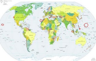
*For Tuesday, 6 June 2006.
LEGEND for OVERVIEW: Size = My surety of area for quake.
Red Circle = Probable quake to STRONG quake.
Triangle = Very Strong or Stronger quake (And usually takes extra days).
Blue Circle, etc. = Uncertainty of symptom area for probable quake.

Places to watch.
Good luck to all.
For Tuesday, 6 June 2006.
----------------------------------------
Hollister, California area (36.891 -121.409)
----------------------------------------
MAP 1.5 2006/06/05 23:21:14 36.632 -121.147 7.2 11 km ( 7 mi) N of Pinnacles, CA
MAP 1.1 2006/06/06 18:58:14 36.529 -121.033 10.2 10 km ( 6 mi) E of Pinnacles, CA
MAP 2.9 2006/06/07 18:40:20 36.552 -121.109 8.8 4 km ( 2 mi) NE of Pinnacles, CA
MAP 1.4 2006/06/07 20:40:04 36.973 -121.555 0.0 5 km ( 3 mi) SSE of Gilroy, CA
Sicily, Italy/Ionian Sea
----------------------------------------
2006-06-06 15:53:00.0 43.40 N 13.03 E 7 ML 2.5 CENTRAL ITALY
(More northern than expected)
Mindanao, Philippines (6.62N 126.47E)
----------------------------------------
2006-06-04 14:03:08.6 9.03 N 126.36 E 60 mb 4.9 MINDANAO, PHILIPPINE ISLANDS
2006-06-04 23:58:15.7 18.79 N 119.76 E 160 f mb 4.8 PHILIPPINE ISLANDS REGION
(2 days early)
Canary Islands area (28.00 N 16.24 W) (Second day symptom and indication of depth - STRONG)
----------------------------------------
06Jun2006 01:39:19.2 14.1N 44.9W 33 mb=5.1 M*GSR NORTHERN MID-ATLANTIC RIDG
(Also posted on the 4th-rethinking symptom location.)
Hawaii (Indication of depth - MEDIUM)
----------------------------------------
MAP 1.8 2006/06/06 00:19:00 19.380 -155.288 2.0 9 km ( 6 mi) SW of Volcano, HI
MAP 2.4 2006/06/06 01:53:39 19.195 -155.663 6.7 15 km ( 9 mi) NE of Hawaiian Ocean View, HI
MAP 2.0 2006/06/06 05:20:50 19.401 -155.597 1.0 25 km ( 16 mi) NNW of Pahala, HI
MAP 2.2 2006/06/06 10:47:52 19.386 -155.039 8.2 14 km ( 8 mi) SE of Fern Forest, HI
MAP 2.0 2006/06/06 16:16:37 19.444 -155.343 13.5 11 km ( 7 mi) W of Volcano, HI
Mariana Islands/Minami Tori Islands area
----------------------------------------
(Nothing found)
British Columbia, Canada/possibly central
----------------------------------------
2006/06/06 19:34:14 48.49N 123.23W 26.3 1.5ML 12 km NE of Victoria,BC
2006/06/06 19:32:50 54.83N 121.02W 10.0* 2.4ML 115 km SW of Dawson Creek,BC
Northern Sumatra
----------------------------------------
2006-06-06 23:02:02 5.0 1.74 N 97.48 E Northern Sumatra, Indonesia
Peace to all.

