*For Saturday, 16 September 2006.
LEGEND for OVERVIEW: Size = My surety of area for quake.
Red Circle = Probable quake to STRONG quake.
Triangle = Very Strong/Stronger quake (Usually takes extra days).
Blue Circle, etc. = Uncertainty of symptom area for probable quake.
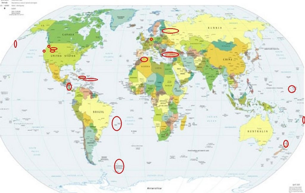
Places to watch.
Good luck to all.
For Saturday, 16 September 2006.
---------------------------------------
Aegean Sea/Turkey area (MEDIUM)
---------------------------------------
2006-09-15 03:23:07.3 38.88N 26.79E 8 MD3.1 AEGEAN SEA
2006-09-15 03:17:51.8 38.39N 27.04E 30 MD2.7 TURKEY
2006-09-15 03:08:47.5 37.21N 30.30E 5 MD3.2 TURKEY
2006-09-15 02:15:37.1 38.87N 26.83E 8 MD2.9 AEGEAN SEA
2006-09-15 01:11:03.8 38.78N 26.72E 27 MD3.1 AEGEAN SEA
2006-09-15 01:02:46.9 38.88N 26.70E 2 ML3.1 AEGEAN SEA
2006-09-15 00:57:47.3 38.80N 26.69E 20 ML3.7 AEGEAN SEA
2006-09-15 00:24:35.9 37.07N 36.07E 14 MD3.3 TURKEY
2006-09-15 00:16:03.7 40.63N 33.05E 5 MD3.2 TURKEY
2006-09-16 02:51:44.0 38.50N 27.73E 11 MD3.3 TURKEY
2006-09-16 09:36:16.7 39.73N 23.79E 13G ML2.9 AEGEAN SEA
2006-09-16 14:26:02.4 38.47N 20.64E ML3.6 GREECE
2006-09-17 00:45:34.1 39.40N 33.15E 5 MD3.4 TURKEY
2006-09-17 01:59:06.5 38.41N 21.97E ML3.0 GREECE
2006-09-17 08:16:35.6 39.16N 21.89E 12G ML3.0 GREECE
2006-09-17 12:58:30.5 37.59N 38.75E 9 MD3.3 TURKEY
2006-09-17 12:32:25.2 39.14N 21.79E 5 G ML2.8 GREECE
Finland to Moscow area
---------------------------------------
2006-09-17 04:07:20.0 53.73N 59.72E ML3.6 URAL MOUNTAINS, RUSSIA, REGION
(More East and South than expected)
Puerto Rico/Virgin Islands (MEDIUM)
---------------------------------------
2.2 2006/09/16 02:42:00 18.233 -66.874 19.6 7 km ( 4 mi) S of Lares, PR
3.5 2006/09/16 13:40:04 18.164 -67.986 105.5 80 km ( 50 mi) WSW of Rincón, PR
Germany
---------------------------------------
2006-09-15 05:29:26.0 48.30N 10.20E 10 G ML2.4 GERMANY
2006-09-16 19:43:05.3 49.36N 6.96E 10 f ML2.9 GERMANY
2006-09-16 21:36:20.4 49.39N 6.94E 2 ML2.6 GERMANY
Montana/Wyoming/Yellowstone
(Fourth day symptom - STRONG. I’m
thinking this is just going to be an
everyday light annoyance for this area.)
---------------------------------------
(Nothing found)
Mariana Islands
---------------------------------------
(Nothing found)
South Atlantic Ocean (33.49S 44.05W)
(STRONG)
---------------------------------------
(Nothing found)
Dominican Republic/Haiti area
---------------------------------------
3.8 2006/09/17 23:00:36 18.915N -68.639W 175.3 34 km (21 mi) NNE of Higüey, La Altagracia, Dominican Republic
4.0 2006/09/18 02:52:01 18.507N -68.378W 166.5 37 km (23 mi) ESE of Higüey, La Altagracia, Dominican Republic
3.9 2006/09/18 01:35:52 19.054N -68.606W 173.6 49 km (31 mi) NNE of Higüey, La Altagracia, Dominican Republic
(2 Extra days)
Nicaragua/Costa Rica
---------------------------------------
06/09/17 21:16:03 12.02N 87.62W 15.0 2.5ML Frente a Corinto
06/09/17 21:08:34 12.92N 88.28W 16.6 3.3MC Frente a El Salvador
06/09/17 05:53:57 12.12N 86.60W 151.9 3.2ML Oeste-Suroeste de Managua
06/09/16 16:40:05 11.20N 86.65W 19.2 2.5ML Frente a La Boquita y Casares
06/09/15 23:19:14 11.19N 86.67W 20.0 2.8MC Frente a La Boquita y Casares
06/09/15 09:05:48 12.76N 86.38W 15.0 2.0ML Nicaragua
06/09/15 04:33:10 11.46N 87.06W 51.1 2.4ML Frente a Masachapa
South of Kamchatka/Aleutian Islands area
---------------------------------------
2006-09-15 11:47:53.7 46.76N 153.07E 60 mb4.7 KURIL ISLANDS, RUSSIA
2.7 2006/09/16 05:24:16 51.193 179.723 25.0 RAT ISLANDS, ALEUTIAN ISLANDS, ALASKA
3.5 2006/09/16 02:28:08 52.060 177.909 200.0 RAT ISLANDS, ALEUTIAN ISLANDS, ALASKA
3.2 2006/09/16 07:27:47 51.393 179.718 50.0 RAT ISLANDS, ALEUTIAN ISLANDS, ALASKA
4.7 2006/09/16 12:34:55 51.344 -178.573 52.7 ANDREANOF ISLANDS, ALEUTIAN IS., ALASKA
2.6 2006/09/16 12:53:43 50.600 -178.685 20.0 ANDREANOF ISLANDS, ALEUTIAN IS., ALASKA
SOUTH SANDWICH ISLANDS REGION
(55.62S 27.23W) (This symptom was
only burning. An indication of volcanic
action. Possibly Thule/Cook Island Caldera: volcano.und.edu
---------------------------------------
2006-09-14 01:09:01 4.8 58.62S 29.98W 150 South Sandwich Islands Region
(2 days early)
Utah/Wyoming area (Goes along with an
earlier post in this list)
---------------------------------------
06/09/16 08:04:32 39.71N 110.78W 9.2 1.3 4.4 mi NE of Helper
06/09/16 08:53:50 39.73N 110.75W 0.5 1.2 6.3 mi NE of Helper
06/09/16 16:02:56 39.73N 110.75W 0.9 1.3 6.1 mi NE of Helper
06/09/16 16:18:52 39.73N 110.75W 0.7 1.7 6.6 mi NE of Helper
Mt. St. Helen’s
---------------------------------------
2.0 2006/09/16 00:41:28 46.197 -122.189 0.7 1 km ( 0 mi) WSW of Mount St. Helens Volcano, WA
1.4 2006/09/16 06:10:18 46.196 -122.189 0.2 1 km ( 1 mi) WSW of Mount St. Helens Volcano, WA
2.7 2006/09/16 10:34:28 46.200 -122.192 0.0 1 km ( 1 mi) W of Mount St. Helens Volcano, WA
2.2 2006/09/16 13:37:20 46.197 -122.188 0.5 1 km ( 0 mi) WSW of Mount St. Helens Volcano, WA
Possibly Samoa (Not a new symptom
but I am trying to pinpoint it a little more
than just Tonga/Fiji area.)
---------------------------------------
2006-09-15 19:48:40 6.3 19.00S 151.74W 20 Society Islands Region
(More East and South than expected.)
NORTH ISLAND OF NEW ZEALAND area
(-39.900 176.830) (Second day symptom
but not as strong. Still really odd - not a
charley horse this time but it seemed to
shoot out to the areas of Vanuatu and
Mammoth Lakes/Tom’s Place. I have no
idea what it means. Leaving it at STRONG.)
---------------------------------------
2006-09-10 02:56:12 5.7 32.01S 179.31E 600 South of Kermadec Islands
Reference Number: 2625883/G
Universal Time: September 16 2006 at 20:34
NZ Standard Time: Sunday, September 17 2006 at 8:34 am
Latitude, Longitude: 35.06°S, 174.02°E
Focal Depth: 5 km
Richter Magnitude: 3.5
Reference Number: 2626040/G
Universal Time: September 17 2006 at 4:19
NZ Standard Time: Sunday, September 17 2006 at 4:19 pm
Latitude, Longitude: 39.97°S, 176.65°E
Focal Depth: 20 km
Richter Magnitude: 3.6
1.1 2006/09/16 01:34:22 37.570 -118.865 5.5 12 km ( 8 mi) SE of Mammoth Lakes, CA
1.5 2006/09/16 10:13:44 37.541 -118.789 4.0 10 km ( 6 mi) WSW of Toms Place, CA
1.2 2006/09/16 11:16:25 37.480 -118.832 3.9 16 km ( 10 mi) SW of Toms Place, CA
2.6 2006/09/16 23:33:48 37.477 -118.819 0.8 15 km ( 10 mi) SW of Toms Place, CA
The Geysers
---------------------------------------
2.2 2006/09/15 04:40:20 38.822 -122.780 1.3 4 km ( 2 mi) NE of The Geysers, CA
1.5 2006/09/15 22:54:08 38.824 -122.795 1.9 3 km ( 2 mi) NNE of The Geysers, CA
1.2 2006/09/16 12:46:25 38.824 -122.801 2.1 3 km ( 2 mi) N of The Geysers, CA
1.5 2006/09/16 13:24:00 38.822 -122.804 2.0 3 km ( 2 mi) N of The Geysers, CA
1.6 2006/09/16 19:23:13 38.807 -122.796 2.1 1 km ( 1 mi) NE of The Geysers, CA
NORTHERN ALGERIA (35.58N 0.12E)
---------------------------------------
(Nothing found)
Peace to all.

posted by Unknown @ 1:21 PM
0 comments
![]()
![]()
