*For Tuesday, 27 June 2006.
LEGEND for OVERVIEW: Size = My surety of area for quake.
Red Circle = Probable quake to STRONG quake.
Triangle = Very Strong/Stronger quake (Usually takes extra days).
Blue Circle, etc. = Uncertainty of symptom area for probable quake.
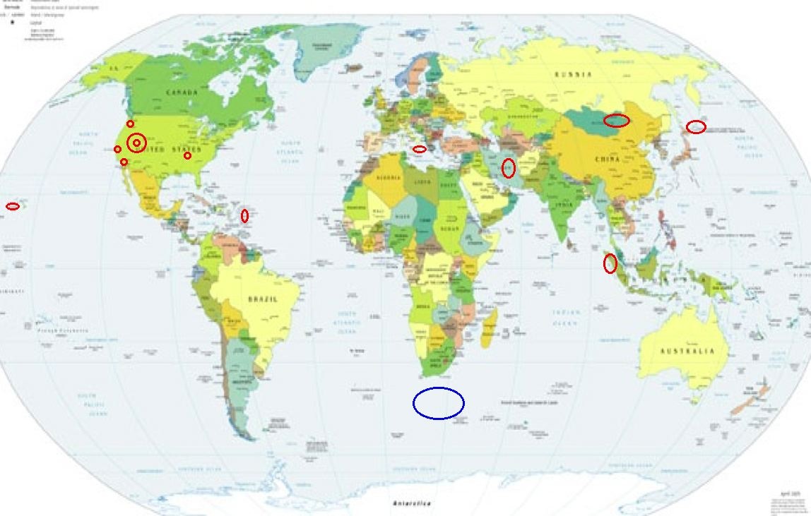
Places to watch.
Good luck to all.
For Tuesday, 27 June 2006.
----------------------------------------
The New Madrid Fault (MEDIUM)
----------------------------------------
1.6 2006/06/28 08:08:03 36.260 -89.470 6.2 1 km(1 mi) ESE of Ridgely, TN
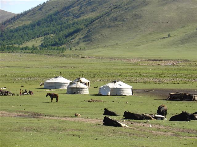
Mongolia area (48.83 N 110.88) (This may
be more than one specific place but it was
all day and strong - EXTREMELY STRONG.)
http://dreamers1.com/russia/Tashanta/Mongolia_Pictures.htm>dreamers1
----------------------------------------
2006-06-28 12:37:05.6 49.83N 91.76E 15 Ms3.8 MONGOLIA
Kuril Islands area (44.57N 148.28E)
----------------------------------------
2006-06-28 17:18:02 5.0 44.30N 149.78E Kuril Islands
29Jun2006 16:39:41.2 46.6N 153.0E 40 mb=5.2 M*GSR KURIL ISLANDS
(2 extra days)
Huntington, Utah (39.415N 111.219W) then
generally Utah/Nevada
----------------------------------------
1.7 2006/06/27 03:29:22 40.248 -111.905 0.4 9 km ( 6 mi) S of Saratoga Springs, UT
2.5 2006/06/27 08:18:08 41.907 -112.542 3.1 16 km ( 10 mi) ESE of Snowville, UT
Northern Sumatra
----------------------------------------
2006-06-27 15:02:19.7 8.96N 93.67E 50 mb5.1 NICOBAR ISLANDS, INDIA, REG
2006-06-28 17:44:05.7 1.07N 98.37E 33 mb5.0 NORTHERN SUMATERA, INDONESIA
Sicily, Italy/Ionian Sea (Medium)
----------------------------------------
2006-06-27 14:00:48.0 38.60N 14.63E 15 ML2.8 SICILY, ITALY
Possibly South of Africa (47.46S 31.79E)
(Unproven symptom)
----------------------------------------
2006-06-25 04:55:24.5 31.42S 21.24E 33 mb5.1 SOUTH AFRICA
(2 days early)
ESE of Alger, WA (48.614 -122.288)
(MEDIUM)
----------------------------------------
1.0 2006/06/28 23:12:12 48.289N 122.626W 17.4 3 km(2 mi) ESE of Oak Harbor, WA
1.7 2006/06/29 06:37:02 48.042N 122.303W 24.8 3 km(2 mi) SSW of Tulalip Bay, WA
Hawaii
----------------------------------------
1.9 2006/06/27 17:00:47 19.474 -155.250 32.3 3 km(2 mi) NNW of Volcano, HI
3.0 2006/06/28 17:20:28 19.377N 155.236W 0.0 6 km(4 mi) S of Volcano, HI
The Virgin Islands (Medium)
----------------------------------------
1.7 2006/06/27 20:36:37 18.178 -67.031 16.7 5 km ( 3 mi) W of Maricao, PR
2.6 2006/06/27 23:13:33 17.871N -65.766W 5.8 19 km (12 mi) SE of Emajagua, PR
2.9 2006/06/27 22:01:13 18.621N -66.119W 89.1 21 km (13 mi) N of Cataño, PR
3.1 2006/06/27 20:21:54 19.095N -67.876W 10.3102 km (64 mi) ENE of Higüey, La Altagracia, Dominican Republic
1.7 2006/06/27 16:36:37 18.178N -67.031W 16.7 5 km ( 3 mi) W of Maricao, PR
Mettler, CA area (35.117N 118.911W)
(MEDIUM)
----------------------------------------
1.1 2006/06/27 01:22:09 35.664 -118.461 11.0 3 km ( 2 mi) N of town of Lake Isabella, CA
2.3 2006/06/27 07:06:02 34.370 -118.980 15.2 7 km ( 4 mi) WSW of Fillmore, CA
Hollister, CA area (36.891 -121.409)
----------------------------------------
1.9 2006/06/28 23:38:05 36.065N 120.193W 15.7 8 km ( 5 mi) NW of Avenal, CA
1.2 2006/06/28 22:07:43 36.026N 120.583W 4.5 20 km (12 mi) NW of Parkfield, CA
1.6 2006/06/28 21:40:20 36.069N 120.197W 13.0 8 km ( 5 mi) NW of Avenal, CA
1.5 2006/06/28 18:36:06 35.897N 120.439W 10.9 1 km ( 0 mi) WSW of Parkfield, CA
Northcentral Iran area (31.45N 56.71E)
(MEDIUM)
----------------------------------------
2006-06-26 03:56:56.1 31.57N 50.34E 31 M 3.1 NORTHERN AND CENTRAL IRAN
2006-06-26 12:52:03.0 36.62N 50.19E 6 M 3.6 NORTHERN AND CENTRAL IRAN
2006-06-26 15:52:31.9 34.23N 47.06E 7 M 3.1 WESTERN IRAN
2006-06-28 14:11:11.0 35.71N 48.99E 14 ML 3.9 WESTERN IRAN
2006-06-28 21:36:35.2 26.26N 56.55E 33 mb 4.7 SOUTHERN IRAN
2006-06-28 21:25:59.2 26.62N 55.85E 16 mb 4.6 SOUTHERN IRAN
2006-06-28 21:02:12.4 27.04N 55.81E 35 mb 5.7 SOUTHERN IRAN
Peace to all.

posted by Unknown @ 2:16 PM
0 comments
![]()
![]()
