*For Tuesday, 10 October 2006.
LEGEND for OVERVIEW: Size = My surety of area for quake.
Red Circle = Probable quake to STRONG quake.
Triangle = Very Strong/Stronger quake (Usually takes extra days).
Blue Circle, etc. = Uncertainty of symptom area for probable quake.
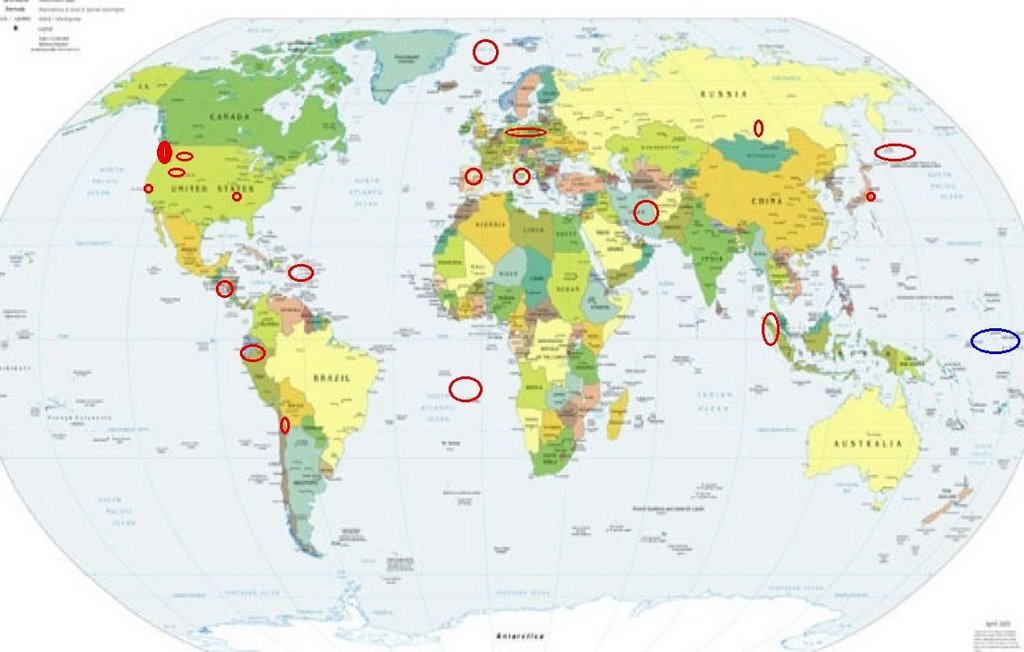
Places to watch.
Good luck to all.
For Tuesday, 10 October 2006.
---------------------------------------
Northcentral Iran (This was an all
day off and on symptom. The last
time was only magnitude 3 and 4
in the form of a swarm. Expecting
the same again. STRONG)
--------------------------------------
2006-10-10 03:41:53.8 37.90N 56.30E 17 M3.1 NORTHERN AND CENTRAL IRAN
2006-10-10 03:32:12.6 31.73N 51.05E 2 ML3.8 NORTHERN AND CENTRAL IRAN
2006-10-10 09:41:42.0 33.04N 58.29E 1 M3.2 NORTHERN AND CENTRAL IRAN
2006-10-10 09:36:25.3 32.62N 55.43E 7 M3.6 NORTHERN AND CENTRAL IRAN
2006-10-11 03:34:35.5 34.38N 60.24E 9 M3.1 NORTHERN AND CENTRAL IRAN
Germany (50.22N 12.67E)/Poland
(STRONG)
--------------------------------------
2006-10-10 03:13:21.0 49.30N 6.90E 10G ML2.0 GERMANY
2006-10-10 03:47:33.4 51.33N 15.94E 2 ML3.3 POLAND
Spring City, UT (39.479 -111.491)
(2 different symptoms - Strong)
--------------------------------------
06/10/09 01:42:48 39.72N 110.77W 9.2 1.1 4.9 mi NE of Helper
06/10/09 05:30:18 39.74N 110.74W 0.1 1.2 7.5 mi NE of Helper
06/10/09 07:35:56 39.70N 110.71W 7.1 1.2 7.9 mi ENE of Helper
06/10/09 17:24:02 39.41N 111.22W 2.2 1.4 15.1 mi WNW of Huntington
06/10/09 18:51:57 39.41N 111.23W 2.0 1.6 15.2 mi E of Spring City
06/10/09 21:15:08 39.42N 111.23W 2.4 1.6 15.1 mi E of Spring City
06/10/09 21:49:22 39.41N 111.23W 2.3 1.4 15.3 mi WNW of Huntington
06/10/10 01:23:35 41.67N 111.71W 1.4 2.7 6.3 mi E of Providence
06/10/10 01:25:59 41.67N 111.71W 8.3 1.0 6.2 mi ESE of Providence
06/10/10 01:31:05 41.67N 111.69W 7.2 1.6 6.7 mi E of Providence
06/10/10 01:50:18 39.42N 111.22W 2.3 1.2 15.1 mi WNW of Huntington
06/10/10 02:00:55 39.41N 111.22W 2.3 1.5 15.2 mi WNW of Huntington
06/10/10 03:21:39 39.72N 110.76W 7.4 1.2 5.8 mi NE of Helper
06/10/10 03:31:09 39.42N 111.22W 4.2 1.4 15.2 mi WNW of Huntington
06/10/10 04:57:49 39.72N 110.75W 0.7 1.3 6.0 mi NE of Helper
06/10/10 05:19:52 39.73N 110.75W 0.7 1.1 6.2 mi NE of Helper
06/10/10 06:01:09 39.41N 111.23W 2.5 1.6 15.2 mi E of Spring City
06/10/10 11:25:49 41.68N 111.69W 8.0 1.2 6.8 mi E of Providence
(I’m trying to pinpoint the Utah symptoms a little better. Provdence is the same longitude but a little more north.)
Northern Sumatra (4.85N 95.14E)
(2 different symptoms - STRONG)
--------------------------------------
2006-10-09 13:45:13 5.0 1.19N 97.06E 20 Northern Sumatra, Indonesia
Kuril Islands (49.97N 158.61E)
--------------------------------------
2006-10-10 11:50:30.3 51.46N 158.16E Ms3.1 NEAR E. CST KAMCHATKA PEN.
TARAPACA, CHILE (19.23S 69.13W)
(Medium)
--------------------------------------
2006-10-10 18:17:09 4.9 31.75S 66.78W 150 La Rioja Province, Argentina
Boulder Creek, California
(37.13 -122.12)(Medium)
--------------------------------------
2.0Q 2006/10/10 19:30:29 37.323 -122.102 0.7 0 km(0 mi) SSE of Quarry near Cupertino, CA(Probable quarry explosion)
1.3 2006/10/10 23:43:06 37.212 -121.606 3.4 10 km(6 mi) NNE of Morgan Hill, CA
The New Madrid Fault/Hayti, MO area
(36.270N 89.770W)
--------------------------------------
1.7 2006/10/10 09:10:59 36.400 -89.530 8.2 5 km ( 3 mi) WNW of Tiptonville, TN
1.5 2006/10/11 06:39:04 36.210 -89.470 6.0 6 km ( 4 mi) S of Ridgely, TN
Lake Baykal, Russia area
--------------------------------------
2006-10-10 16:15:15.9 55.48N 114.31E 10 Ms3.3 EAST OF LAKE BAYKAL, RUSSIA
Puerto Rico/Virgin Islands
(2 different symptoms - STRONG)
--------------------------------------
3.3 2006/10/10 03:20:24 18.770 -64.379 58.1 8 km(5 mi) NW of Settlement, British Virgin Islands
2.5 2006/10/10 22:53:11 17.923N -66.045W 13.1 5 km (3 mi) SSE of Arroyo, PR
2.7 2006/10/10 18:45:58 18.489N -66.066W 100.1 9 km (5 mi) N of San Juan, PR
1.0 2006/10/10 15:57:54 17.890N -66.641W 18.0 14 km (9 mi) S of Ponce, PR
2.1 2006/10/10 13:15:49 17.951N -65.877W 16.7 6 km (4 mi) S of Emajagua, PR
3.1 2006/10/10 00:42:55 18.882N -64.986W 41.7 58 km (36 mi) NNW of Little
Harbour, Jost van Dyke, British Virgin Islands
Mohns Ridge (71.99 -1.30)
(MEDIUM)
--------------------------------------
MOHNS RIDGE
Origin time Lat Lon Azres Timres Wres Nphase Ntot Nsta Netmag
2006-282:14.43.55.0 72.68 -2.92 6.68 0.16 1.83 2 2 1 1.42
VOERING BASIN
Origin time Lat Lon Azres Timres Wres Nphase Ntot Nsta Netmag
2006-283:09.07.28.0 65.79 7.38 4.00 0.22 1.22 2 2 1 2.11
Peru-Ecuador border area
(4.28S 79.38W)(Strong)
--------------------------------------
2006-10-12 01:31:53 4.6 18.04S 69.17W 121 Northern Chile
(2 extra days and off some on coordinates)
Vashon, WA (47.410 -122.516)
then Mt. St. Helen’s
and other areas of Washington State
and Mt. Hood/to Oregon
(Almost non-specific entire PNW)
--------------------------------------
2.2 2006/10/10 00:24:17 46.231 -122.208 2.6 4 km ( 3 mi) NNW of Mount St. Helens Volcano, WA
1.4 2006/10/10 00:33:50 46.196 -122.200 0.4 2 km ( 1 mi) WSW of Mount St. Helens Volcano, WA
1.7 2006/10/10 03:13:53 48.584 -122.260 4.0 8 km ( 5 mi) SE of Alger, WA
2.2 2006/10/10 06:06:48 46.196 -122.189 0.5 1 km(1 mi) WSW of Mount St. Helens Volcano, WA
1.5 2006/10/10 07:51:00 45.521 -122.661 13.6 2 km ( 1 mi) W of Portland, OR
1.8 2006/10/10 09:40:53 46.749 -119.375 0.0 18 km ( 11 mi) WSW of Othello, WA
1.6 2006/10/10 10:21:36 47.563 -121.756 11.0 7 km ( 5 mi) ENE of Snoqualmie, WA
1.6 2006/10/10 12:48:19 46.856 -121.600 4.8 32 km ( 20 mi) S of Greenwater, WA
2.3 2006/10/10 15:40:22 46.195 -122.195 0.3 1 km ( 1 mi) WSW of Mount St. Helens Volcano, WA
1.8 2006/10/10 20:13:15 46.517 -122.416 18.8 5 km ( 3 mi) ESE of Mossyrock, WA
3.3 2006/10/10 20:32:08 46.200 -122.199 0.0 1 km ( 1 mi) W of Mount St. Helens Volcano, WA
Honshu, Japan
--------------------------------------
2006-10-10 23:58:07.3 37.23N 142.70E 40 Mw5.9 OFF EAST COAST OF HONSHU, JAPAN
Central Italy
--------------------------------------
(Nothing found)
Montana
--------------------------------------
1.2 2006/10/10 12:27:39 44.444 -110.984 7.6 26 km(16 mi) SSE of West Yellowstone, MT
1.0 2006/10/10 12:26:30 44.440 -110.966 8.3 27 km(17 mi) SSE of West Yellowstone, MT
Nicaragua and Coast of
(11.29N 86.74W)
(Volcanic - Strong)
--------------------------------------
06/10/10 22:06:17 11.90N 86.64W 81.8 2.7MC Frente a Masachapa
06/10/10 19:01:42 12.19N 87.51W 11.9 2.8MC Frente a Corinto
06/10/10 12:22:37 10.14N 85.65W 206.5 3.1ML Costa Rica
06/10/10 12:09:38 10.22N 86.06W 91.5 3.6ML Oceano Pacífico de Costa Rica
06/10/10 02:10:54 12.38N 86.54W 6.1 1.6MC Cerca del volcan Momotombo
06/10/10 02:05:43 12.69N 89.63W 29.7 4.2ML Frente a El Salvador
Southern Mid Atlantic Ridge
(17.71S 13.64W)(Medium)
--------------------------------------
(Nothing found)
France (48.12N 4.01W)
--------------------------------------
2006-10-10 16:48:57.5 48.62N 2.22W 2 ML2.9 FRANCE
2006-10-10 19:01:24.1 43.04N 0.70W 10 ML2.7 PYRENEES
Possibly Guam/Caroline Islands
(Unproven symptom)
--------------------------------------
2006-10-10 09:17:44.8 21.65N 143.06E 270 mb4.6 MARIANA ISLANDS REGION?
(I will watch for a repeat of this symptom.)
Peace to all.

posted by Unknown @ 4:12 PM
0 comments
![]()
![]()
