*For Monday, 1 May 2006.
LEGEND for OVERVIEW: Size = My surety of area for quake.
Red Circle = Probable quake to STRONG quake.
Triangle = Very Strong or Stronger quake (And usually takes extra days).
Blue Circle, etc. = Uncertainty of symptom area for probable quake.
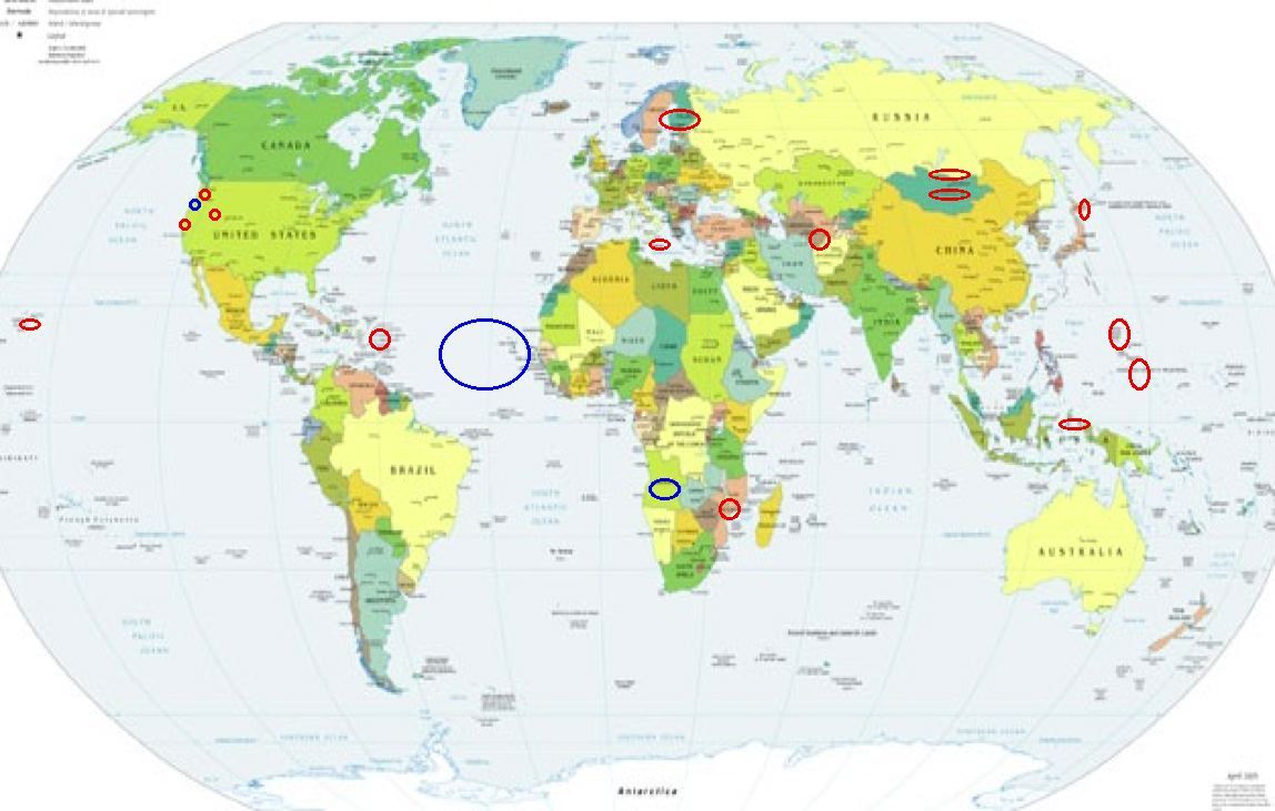
Places to watch.
Good luck to all.
For Monday, 1 May 2006.
----------------------------------------
Possibly Central North Atlantic to West Coast of Northern Africa (New symptom and since it was pretty strong. STRONG.)
----------------------------------------
2006-04-28 07:22:44 5.0 3.91 N 31.68 W Central Mid Atlantic Ridge
(3 days early?)
2006-05-01 22:41:53.3 11.61 S 12.88 W 33 mb 5.0 ASCENSION ISLAND REGION?
2006-05-01 04:07:31.4 36.33 N 3.47 W 2 ML 3.2 STRAIT OF GIBRALTAR
2006-05-01 14:08:49.8 35.20 N 3.84 W 4 mb 3.3 STRAIT OF GIBRALTAR
2006-05-02 01:27:55.3 27.64 N 15.63 W 46 mb 2.9 CANARY ISLANDS, SPAIN REG
2006-05-02 08:20:55.6 35.14 N 3.87 W 52 mb 3.7 STRAIT OF GIBRALTAR
Turkmenistan (39.35 N 54.91 E) (STRONG)
----------------------------------------
(Nothing found)
Sicily, Italy to Ionian Sea (STRONG)
----------------------------------------
2006-05-01 20:01:41.0 37.56 N 20.93 E ML 3.1 IONIAN SEA 2006-05-01 20:10
2006-05-01 19:10:00.0 36.59 N 15.79 E 32 ML 2.8 SICILY, ITALY
Possibly Angola, Africa and then Mozambique
----------------------------------------
(Nothing found)
Hokkaido (Medium)
----------------------------------------
2006-05-03 13:07:28.2 43.17 N 144.99 E 30 mb 5.3 HOKKAIDO, JAPAN, REGION
(2 extra days)
San Francisco and North of
----------------------------------------
MAP 1.4 2006/05/01 00:54:49 37.809 -122.069 11.2 6 km ( 4 mi) SE of Moraga, CA
MAP 2.0 2006/05/01 02:30:23 37.744 -122.148 5.0 4 km ( 2 mi) N of San Leandro, CA
Southern Molucca Sea (1.6S 125.1E) (Strong)
----------------------------------------
2006-05-01 17:05:30 5.5 5.56S 146.94E Eastern New Guinea Reg., P.N.G.
(More South and East)
Russia/Mongolia border (51.3N 97.8E) and then more South (STRONG for both areas)
----------------------------------------
(Posted on 30 April.)
Hawaii (2 different symptoms - Strong)
----------------------------------------
MAP 3.2 2006/05/01 04:47:35 19.923 -155.197 7.2 8 km ( 5 mi) SSE of Laupahoehoe, HI
MAP 2.2 2006/05/01 07:59:50 20.406 -155.877 36.2 19 km ( 12 mi) NNW of Hawi, HI
MAP 2.4 2006/05/01 19:18:33 19.547 -156.376 2.0 41 km ( 26 mi) WSW of Kailua, HI
MAP 1.7 2006/05/01 23:34:42 19.204 -155.463 0.0 2 km ( 1 mi) E of Pahala, HI
Mt. St. Helen’s (Medium)
----------------------------------------
MAP 1.7 2006/05/01 01:02:48 46.197 -122.192 1.0 1 km ( 1 mi) WSW of Mount St. Helens Volcano, WA
MAP 2.9 2006/05/01 05:32:15 46.187 -122.173 0.0 2 km ( 1 mi) SSE of Mount St. Helens Volcano, WA
Puerto Rico/Virgin Islands area (Medium)
----------------------------------------
MAP 2.5 2006/05/01 11:38:09 18.681 -64.958 36.3 37 km ( 23 mi) N of CHARLOTTE AMALIE, US Virgin Islands
MAP 3.3 2006/05/01 17:58:45 17.602 -68.532 4.6 103 km ( 64 mi) SSE of La Romana, Dominican Republic
Mariana Islands then Caroline Islands (medium for both)
----------------------------------------
01May2006 22:37:48.2 20.1N 146.8E 33 mb=5.1 M GSR MARIANA ISLANDS REGION
Possibly Bandon, Oregon (43.480 -126.993)
----------------------------------------
MAP 2.2 2006/05/01 09:47:20 40.293 -124.290 11.3 4 km ( 2 mi) S of Petrolia, CA
Utah
----------------------------------------
MAP 1.4 2006/05/01 05:38:12 39.667 -110.519 2.6 16 km ( 10 mi) NNW of East Carbon, UT
MAP 1.6 2006/05/01 09:17:15 39.453 -111.209 4.7 23 km ( 15 mi) ESE of Mount Pleasant, UT
MAP 1.5 2006/05/01 12:41:44 39.610 -110.397 1.2 6 km ( 4 mi) N of Sunnyside, UT
MAP 1.4 2006/05/01 14:42:35 39.612 -110.402 1.4 7 km ( 4 mi) N of Sunnyside, UT
MAP 2.7 2006/05/01 16:30:08 37.006 -113.410 6.0 15 km ( 9 mi) SSE of Washington, UT
MAP 1.5 2006/05/01 17:08:22 39.611 -110.398 1.2 7 km ( 4 mi) N of Sunnyside, UT
MAP 1.3 2006/05/01 22:33:54 38.982 -111.343 14.7 10 km ( 7 mi) NW of Emery, UT
MAP 1.2 2006/05/01 21:28:02 39.726 -110.745 1.3 10 km ( 7 mi) ENE of Helper, UT
MAP 1.9 2006/05/01 21:23:59 41.142 -112.885 7.1 64 km ( 40 mi) W of Hooper, UT
MAP 1.4 2006/05/01 22:54:25 39.410 -111.209 4.6 23 km ( 14 mi) WNW of Huntington, UT
Finland/Sweden area (Medium)
----------------------------------------
(Nothing found)
Peace to all.

posted by Unknown @ 2:56 PM
5 comments
![]()
![]()
