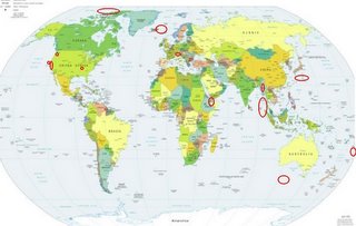
*For Sunday, 19 February 2006.
LEGEND for OVERVIEW:
Size = My surety of area for quake.
Red Circle = Probable quake to STRONG quake.
Triangle = Very Strong or Stronger quake (And usually takes extra days).
Blue Circle, etc. = Uncertainty of symptom area for probable quake.

Places to watch.
Good luck to all.
For Sunday, 19 February 2006.
----------------------------------------
Parkfield Fault (Medium)
----------------------------------------
(Nothing found)
Mt. St. Helen's
----------------------------------------
MAP 3.0 2006/02/19 15:23:52 46.193 -122.195 0.0 1 km ( 1 mi) SW of Mount St. Helens Volcano, WA
Switzerland area (46.5N 8.8E) (2 different symptoms - Strong)
----------------------------------------
(Nothing found)
Possibly Hayti, Missouri (36.270N 89.770W) (New area symptom - if this quakes I will have another area proven.)
----------------------------------------
(Nothing found)
Ethiopia (11.82 N 43.70 E) (Second day symptom - Strong)
----------------------------------------
2006-02-21 01:36:32.7 11.67N 43.27E 29 ML4.0 ETHIOPIA
2006-02-21 01:26:42.4 11.62N 42.99E 12 ML3.7 ETHIOPIA
2006-02-21 01:22:23.3 11.61N 43.17E 19 ML4.0 ETHIOPIA
2006-02-21 06:38:30.3 11.62N 43.06E 9 ML4.2 ETHIOPIA
2006-02-21 11:30:39.4 11.42N 43.14E 12 ML4.2 ETHIOPIA
2006-02-21 11:27:56.3 11.83N 43.07E 6 ML3.3 ETHIOPIA
2006-02-21 11:21:08.9 11.44N 42.94E 8 ML4.4 ETHIOPIA
2006-02-21 11:00:45.4 11.44N 43.23E ML3.5 ETHIOPIA
2006-02-21 12:34:50.8 11.94N 43.43E 6 ML3.1 ETHIOPIA
2006-02-21 12:10:43.5 11.40N 43.02E 6 ML3.8 ETHIOPIA
2006-02-21 12:03:12.6 11.48N 43.46E 15 ML3.6 ETHIOPIA
2006-02-21 11:51:49.6 11.81N 43.19E 14 ML4.1 ETHIOPIA
2006-02-21 11:43:14.3 11.37N 43.13E 9 ML3.9 ETHIOPIA
(2 extra days)
The Alpha Ridge in the Arctic Ocean
----------------------------------------
19Feb2006 00:20:08.6 67.8N 166.9W 33 mb=4.5 M GSR BERING STRAIT
(This might be the right quake for the symptom - I will need a repeat performance to be sure.)
Myanmar area (24.92 N 93.72 E)
----------------------------------------
19feb06 21:18:55 4.7ML 28.240 83.890 NA 10.2 kms W of Pokhara (Pokhara), Nepal
21feb06 10:59:15 4.6Mb 29.600 81.340 060.0 3.2 kms SE of Talkot (Bajhang), Nepal
(2 extra days)
Iceland/Norwegian Sea area (Medium)
----------------------------------------
ICELAND REGION
Origin time Lat Lon Azres Timres Wres Nphase Ntot Nsta Netmag
2006-049:09.18.40.0 66.17 -12.18 9.60 0.06 2.46 2 2 1 2.67
Tonga (Medium)
----------------------------------------
MAP 4.4 2006/02/18 18:33:33 -21.227 -179.306 582.9 FIJI REGION
Kyushu to Bonin Islands area
----------------------------------------
2006/02/19,17:11 32.1N 129.9E 10 km Mj 4.1 W_OFF_AMAKUSA_ISLAND 96.50
2006/02/19,07:08 30.6N 131.2E 30 km Mj 3.5 NEAR_TANEGASHIMA_ISLAND 79.62
Petrolia, California
----------------------------------------
MAP 2.7 2006/02/20 02:55:28 40.340 -124.255 34.8 3 km ( 2 mi) ENE of Petrolia, CA
South of Australia (.49.12S 115.93E)
----------------------------------------
18/02/2006 17:16:54 -32.883 138.565 0 2.6 Booleroo SA
(Not the right area - this South of Australia quake may not occur until the 24th or later.)
Nicobar/Andaman/Northern Sumatra area (Medium)
----------------------------------------
(Nothing found)
Peace to all.

