*For Sunday, 25 June 2006.
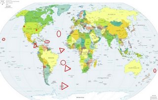
LEGEND for OVERVIEW: Size = My surety of area for quake.
Red Circle = Probable quake to STRONG quake.
Triangle = Very Strong/Stronger quake (Usually takes extra days).
Blue Circle, etc. = Uncertainty of symptom area for probable quake.

Places to watch.
(As usual, Very Strong and stronger quakes
can take 5 or more days. Most come 3 to 5
days after symptoms.)
Good luck to all.
For Sunday, 25 June 2006.
----------------------------------------
ENE of San Lucas, CA (36.237 -120.804)
(Second day symptom - STRONG.)
----------------------------------------
2.3 2006/06/25 00:31:18 36.564 -121.053 5.1 9 km(5 mi) ENE of Pinnacles, CA
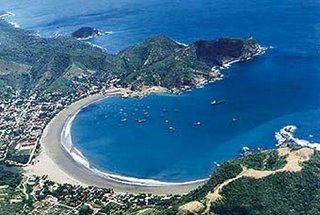
Coastal area of Nicaragua to Costa Rica
(Second day for this area but different
symptoms and stronger - VERY STRONG.)
http://centralamerica.com/nicaragua/gallery/

----------------------------------------
06/06/26 18:26:51 11.65N 86.98W 15.0 3.3ML Frente a Masachapa
06/06/26 15:58:56 12.32N 86.82W 54.9 2.7ML León
06/06/26 11:21:07 11.43N 86.62W 15.0 3.7ML Frente a La Boquita y Casares
06/06/26 11:09:10 11.41N 86.97W 9.4 1.8ML Frente a Masachapa
06/06/25 21:30:51 13.86N 91.01W 132.5 4.0ML Frente a Guatemala
06/06/25 14:02:26 11.23N 86.56W 11.1 2.7MC Frente a El Astillero
06/06/25 08:03:33 11.67N 87.08W 67.5 3.1MC Frente a Puerto Sandino
06/06/25 02:42:13 12.04N 87.76W 1.0 2.7ML Oceano Pacífico de Nicaragua
Central Mid Atlantic Ridge (4.39N 32.13W)
then South Sandwich Islands and up the
Southern Mid Atlantic Ridge (EXTREMELY STRONG)
http://atlas.geo.cornell.edu/education/
instructor/tectonics/spreading.html

----------------------------------------
2006-06-27 03:09:16 5.9 67.65S 52.95W Southwestern Atlantic Ocean
(2 extra days)
Northern Mid Atlantic Ridge (33.0N 38.6W)
----------------------------------------
2006-06-23 08:02:49 4.8 19.08N 46.04W Northern Mid Atlantic Ridge
(2 days early)
2006-06-24 22:45:48.9 59.96N 29.46W 33 mb4.4 NORTH ATLANTIC OCEAN
2006-06-30 23:18:32.8 31.88N 45.61W 33 mb4.8 NORTH ATLANTIC OCEAN
(5 extra days)
Puerto Rico/Virgin Islands
----------------------------------------
1.8 2006/06/25 16:13:32 18.048N -66.686W 17.7 2 km(1 mi) E of Tallaboa Alta, PR
3.1 2006/06/25 15:13:33 19.142N -67.851W 12.1 107 km(67 mi) NW of San Antonio, PR
Hawaii (2 different symptoms - Strong)
----------------------------------------
2.5 2006/06/25 10:43:10 19.397 -155.496 18.7 21 km (13 mi) N of Pahala, HI
JUJUY PROVINCE, ARGENTINA (22.95S 66.42W)
----------------------------------------
2006-06-25 04:15:17.8 22.98S 66.08W 217 mb4.6 JUJUY PROVINCE, ARGENTINA
The New Madrid Fault
----------------------------------------
1.7 2006/06/24 05:54:02 36.110 -89.420 10.2 9 km ( 5 mi) NNW of Dyersburg, TN
2.5 2006/06/24 21:51:31 36.320 -82.370 11.1 2 km ( 1 mi) S of Johnson City, TN
1.7 2006/06/25 21:34:38 36.540 -89.670 7.6 6 km ( 4 mi) WNW of Marston, MO
1.5 2006/06/25 22:17:10 36.540 -89.660 8.2 5 km ( 3 mi) WNW of Marston, MO
Kermadec Islands
----------------------------------------
2006-06-27 02:59:17 6.6 19.74S 178.20W Fiji Islands Region
2006-06-27 08:36:17 4.8 14.56S 176.38W Fiji Islands Region
(2 extra days)
Trinidade Island (21.0S 30.0W) (This seems
to be on track with the Mid Atlantic Ridge
symptoms for the day! - Strong.)
----------------------------------------
(Nothing found)
Peace to all.

