*For Sunday, 2 April 2006.
LEGEND for OVERVIEW: Size = My surety of area for quake.
Red Circle = Probable quake to STRONG quake.
Triangle = Very Strong or Stronger quake (And usually takes extra days).
Blue Circle, etc. = Uncertainty of symptom area for probable quake.
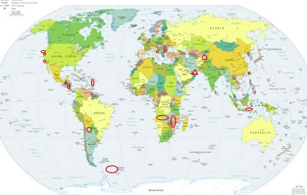
Places to watch.
Good luck to all.
For Sunday, 2 April 2006.
----------------------------------------
San Diego area
----------------------------------------
MAP 2.1 2006/04/02 23:30:26 32.980 -117.539 16.8 26 km ( 16 mi) W of Del Mar, CA
Hindu Kush
----------------------------------------
2006-04-01 00:08:08.0 36.36 N 70.57 E 180 mb 4.4 HINDU KUSH, AFGHANISTAN, REG
Taiwan area
----------------------------------------
MAP 6.2 2006/04/01 10:02:20 22.887 121.281 9.0 TAIWAN REGION
MAP 4.8 2006/04/01 10:40:23 23.144 121.187 10.0 TAIWAN
MAP 4.2 2006/04/01 12:56:50 22.669 121.871 10.0 TAIWAN REGION
(I also posted the above for the 29th of March.)
2006-04-04 12:49:29.9 22.84 N 121.11 E 33 mb 5.0 TAIWAN REGION
MAP 4.4 2006/04/04 06:59:03 22.906 121.469 20.7 TAIWAN REGION
MAP 4.6 2006/04/04 06:48:34 22.983 121.429 29.3 TAIWAN REGION
(2 days extra)
Nicaragua area (11.06N 88.21W) then Guatamala area (Strong for Nicaragua area.)
----------------------------------------
06/04/03 08:09:45 13.07N 86.92W 100.0 2.7ML Nicaragua
06/04/02 20:14:54 11.46N 86.26W 101.8 2.6ML Frente a El Astillero
06/04/02 08:51:17 11.19N 86.95W 64.2 3.2ML Frente a Masachapa
(Nothing for Guatamala found)
Virgin Islands (Strong)
----------------------------------------
MAP 2.9 2006/04/01 00:28:06 18.901 -64.973 25.9 59 km ( 37 mi) NNW of Little Harbour, British Virgin Islands
MAP 2.4 2006/04/01 00:27:48 18.887 -66.307 45.0 46 km ( 29 mi) N of Breñas, PR
MAP 2.8 2006/04/01 07:34:53 18.428 -66.861 23.0 3 km ( 2 mi) ESE of Piedra Gorda, PR
MAP 3.7 2006/04/01 09:17:46 18.314 -67.954 117.1 74 km ( 46 mi) W of Rincón, PR
MAP 3.9 2006/04/01 09:04:47 18.893 -68.955 156.6 16 km ( 10 mi) NNE of El Seybo, Dominican Republic
MAP 3.2 2006/04/01 12:17:56 18.930 -64.964 8.1 62 km ( 38 mi) NNW of Little Harbour, British Virgin Islands
MAP 1.6 2006/04/01 20:26:25 17.959 -67.070 6.6 3 km ( 2 mi) SW of La Parguera, PR
Romania (Strong)
----------------------------------------
31Mar2006 05:35:49.0 45.9N 26.9E 75 ML=3.8 M*ROM ROMANIA
(2 days early)
Petrolia, California area (40.267 -124.081) (Medium)
----------------------------------------
MAP 1.5 2006/04/02 23:08:02 40.278 -123.745 17.6 19 km ( 12 mi) NNE of Redway, CA
Angola or Zambia (New symptom) and Mozambique area
----------------------------------------
2006-04-04 02:13:34 4.9 21.21 S 32.63 E Mozambique
(2 extra days)
The Geysers (MEDIUM)
----------------------------------------
MAP 1.9 2006/04/01 02:00:23 38.828 -122.790 3.2 4 km ( 2 mi) NNE of The Geysers, CA
MAP 1.5 2006/04/02 12:18:40 38.812 -122.817 2.3 2 km ( 1 mi) NNW of The Geysers, CA
MAP 1.7 2006/04/02 13:15:35 38.798 -122.764 2.2 4 km ( 2 mi) E of The Geysers, CA
MAP 1.7 2006/04/02 17:35:01 38.817 -122.784 2.5 3 km ( 2 mi) NE of The Geysers, CA
MAP 1.7 2006/04/02 22:14:08 38.811 -122.812 4.6 1 km ( 1 mi) NNW of The Geysers, CA
MAP 2.2 2006/04/02 23:01:46 38.828 -122.796 2.1 3 km ( 2 mi) NNE of The Geysers, CA
MAP 1.3 2006/04/03 00:13:29 38.835 -122.803 2.7 4 km ( 3 mi) N of The Geysers, CA
MAP 1.9 2006/04/03 00:29:46 38.826 -122.799 4.3 3 km ( 2 mi) NNE of The Geysers, CA
MAP 1.9 2006/04/03 11:21:32 38.794 -122.808 4.0 0 km ( 0 mi) SSW of The Geysers, CA
MAP 1.7 2006/04/03 13:40:18 38.815 -122.827 3.0 3 km ( 2 mi) NW of The Geysers, CA
Italy
----------------------------------------
2006-04-01 16:42:26.5 44.50 N 10.02 E 2 ML 3.5 NORTHERN ITALY
2006-04-01 09:41:00.0 37.88 N 14.37 E 58 ML 2.5 SICILY, ITALY
Scotia Sea (60.40 S 42.64 W)
----------------------------------------
2006-04-04 01:43:23 5.9 56.12 S 26.49 W South Sandwich Islands Region
(2 extra days)
Gulf of Oman area/Southern Iran (VERY STRONG and indication of deep quake.) (Second day of symptom but already at VERY STRONG.)
http://visibleearth.nasa.gov/view_rec.php?id=2363>visibleearth

----------------------------------------
(This is a symptom that is now in question. I posted the swarm and large quakes on 2 different lists because there were 2 different symptoms. Something I have to figure out yet.)
Jujuy Province, Argentina area (23.53S 66.46W) (Strong)
----------------------------------------
2006-04-04 05:47:30.4 22.95 S 66.42 W 165 mb 4.7 JUJUY PROVINCE, ARGENTINA
(2 extra days)
Java Sea (-5.559 110.074) (MEDIUM)
----------------------------------------
(Nothing found)
Peace to all.

posted by Unknown @ 1:38 PM
0 comments
![]()
![]()
