*For Wednesday, 22 March 2006.
LEGEND for OVERVIEW: Size = My surety of area for quake.
Red Circle = Probable quake to STRONG quake.
Triangle = Very Strong or Stronger quake (And usually takes extra days).
Blue Circle, etc. = Uncertainty of symptom area for probable quake.
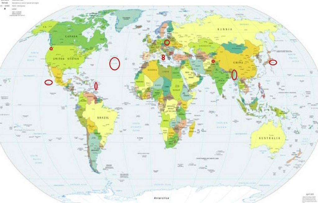
Places to watch.
Good luck to all.
For Wednesday, 22 March 2006.
----------------------------------------
Mt. St. Helen’s
----------------------------------------
MAP 2.7 2006/03/21 06:47:18 46.198 -122.189 0.0 1 km ( 0 mi) WSW of Mount St. Helens Volcano, WA
MAP 1.0 2006/03/21 08:23:39 46.196 -122.194 0.6 1 km ( 1 mi) WSW of Mount St. Helens Volcano, WA
MAP 1.3 2006/03/21 16:38:32 46.198 -122.185 0.0 0 km ( 0 mi) WSW of Mount St. Helens Volcano, WA
Sicily, Italy and Southern Italy
----------------------------------------
2006-03-22 03:24:03.0 38.84 N 15.82 E 17 ML 3.0 SICILY, ITALY
2006-03-22 22:45:26.1 39.05 N 8.24 E 10 mb 3.2 SARDINIA, ITALY
Revilla Gigedo, Mexico (medium)
----------------------------------------
2006-03-20 23:37:12 5.1 18.85 N 101.82 W Guerrero, Mexico
Mid-Atlantic Ridge (31.81 N 40.93 W)
----------------------------------------
MAP 4.6 2006/03/20 03:16:49 0.828 -27.998 10.0 CENTRAL MID-ATLANTIC RIDGE
2006-03-22 15:07:58 5.0 13.67 S 14.68 W Southern Mid Atlantic Ridge
The Virgin Islands
----------------------------------------
MAP 2.2 2006/03/21 20:00:49 17.836 -67.022 39.8 16 km ( 10 mi) S of La Parguera, PR
MAP 2.5 2006/03/21 17:48:27 19.053 -66.416 11.1 65 km ( 41 mi) N of Breñas, PR
MAP 2.3 2006/03/21 15:05:32 18.038 -65.422 17.0 9 km ( 6 mi) SE of Esperanza, PR
MAP 3.6 2006/03/21 13:53:20 19.604 -66.139 24.8 127 km ( 79 mi) N of Dorado, PR
MAP 3.3 2006/03/21 11:32:00 19.087 -64.982 9.0 78 km ( 49 mi) NNW of Little Harbour, British Virgin Islands
MAP 3.6 2006/03/21 11:29:16 19.476 -68.585 17.2 84 km ( 52 mi) ENE of Samaná, Dominican Republic
MAP 2.7 2006/03/21 10:37:49 19.278 -64.830 25.2 81 km ( 50 mi) NW of Settlement, British Virgin Islands
MAP 3.0 2006/03/21 10:36:51 19.297 -64.897 49.9 87 km ( 54 mi) NW of Settlement, British Virgin Islands
MAP 3.4 2006/03/21 04:00:11 19.226 -64.960 11.5 87 km ( 54 mi) NW of Settlement, British Virgin Islands
MAP 3.3 2006/03/21 03:16:42 19.100 -64.982 5.6 80 km ( 50 mi) NNW of Little Harbour, British Virgin Islands
MAP 3.3 2006/03/21 03:16:41 19.179 -64.978 5.7 85 km ( 53 mi) NW of Settlement, British Virgin Islands
MAP 3.1 2006/03/21 02:53:14 19.219 -64.956 5.5 86 km ( 54 mi) NW of Settlement, British Virgin Islands
MAP 2.9 2006/03/21 02:51:18 19.224 -64.974 9.2 88 km ( 55 mi) NW of Settlement, British Virgin Islands
MAP 3.2 2006/03/21 02:05:29 18.327 -67.576 112.3 34 km ( 21 mi) W of Rincón, PR
MAP 3.1 2006/03/21 00:25:08 19.283 -64.911 25.3 87 km ( 54 mi) NW of Settlement, British Virgin Islands
MAP 3.2 2006/03/21 00:20:01 19.264 -64.957 5.3 89 km ( 56 mi) NW of Settlement, British Virgin Islands
MAP 2.8 2006/03/21 00:12:55 19.140 -64.988 7.9 84 km ( 52 mi) WNW of Settlement, British Virgin Islands
MAP 2.8 2006/03/21 00:12:07 19.226 -65.001 10.7 90 km ( 56 mi) NW of Settlement, British Virgin Islands
MAP 2.6 2006/03/21 00:11:28 19.191 -64.996 37.4 88 km ( 54 mi) NW of Settlement, British Virgin Islands
MAP 3.4 2006/03/22 19:15:24 19.793 -64.503 14.4 120 km ( 74 mi) N of Settlement, British Virgin Islands
MAP 2.0 2006/03/22 14:10:40 18.005 -66.518 16.1 2 km ( 1 mi) ESE of Capitanejo, PR
MAP 2.1 2006/03/22 12:00:33 17.895 -67.354 29.4 20 km ( 12 mi) WSW of Pole Ojea, PR
MAP 1.2 2006/03/22 10:42:44 18.005 -67.031 10.8 4 km ( 2 mi) NNE of La Parguera, PR
MAP 3.1 2006/03/22 10:21:49 19.660 -67.644 12.2 145 km ( 90 mi) NNW of Isabela, PR
MAP 3.5 2006/03/22 07:51:42 19.123 -65.352 20.6 91 km ( 57 mi) N of Culebra, PR
MAP 2.9 2006/03/22 07:08:51 18.941 -65.872 44.2 57 km ( 35 mi) N of Suárez, PR
MAP 3.1 2006/03/22 03:47:12 19.208 -64.870 41.1 79 km ( 49 mi) NW of Settlement, British Virgin Islands
(I did not have very many symptoms for this amount of movement.)
Islamabad, Pakistan (STRONG)
----------------------------------------
2006-03-22 07:51:40.7 40.74 N 77.61 E 40 f mb 4.9 KYRGYZSTAN-XINJIANG BDR REG
2006-03-22 19:06:02.0 37.51 N 69.11 E ML 3.1 AFGHANISTAN-TAJIKISTAN BDR REG
23Mar2006 13:43:42.5 36.9N 71.3E150 mb=4.9 M*GSR AFGHANISTAN-TAJIKISTAN BOR
23Mar2006 16:07:13.6 39.5N 71.7E 20 mb=4.6 M*GSR TAJIKISTAN
(Near but not Islamabad - I will watch for a closer quake.)
Poland (STRONG)
----------------------------------------
2006-03-22 04:01:29.5 50.03 N 18.46 E 4 ML 2.0 POLAND
2006-03-22 04:36:56.0 54.14 N 19.36 E 33 ML 4.1 POLAND
2006-03-22 04:37:39.2 51.20 N 15.96 E 10 ML 2.4 POLAND
Myanmar, India area
----------------------------------------
(Posted on the 21st.)
Honshu, Japan (STRONG - a dislocation type of symptom.)
----------------------------------------
25Mar2006 23:59:08.3 29.6N 140.1E 80 mb=4.6 M*GSR SOUTH OF HONSHU, JAPAN
26Mar2006 18:21:58.0 32.3N 141.7E 33 mb=4.7 M GSR SOUTH OF HONSHU, JAPAN
(Posted these on the 25th of March but the symptoms for this day suggest they belong here. 3 and 4 extra days.)
Peace to all.

posted by Unknown @ 4:16 PM
0 comments
![]()
![]()
