*For Friday, 17 November 2006.
LEGEND for OVERVIEW: Size = My surety of area for quake.
Red Circle = Probable quake to STRONG quake.
Triangle = Very Strong/Stronger quake (Usually takes extra days).
Blue Circle, etc. = Uncertainty of symptom area for probable quake.
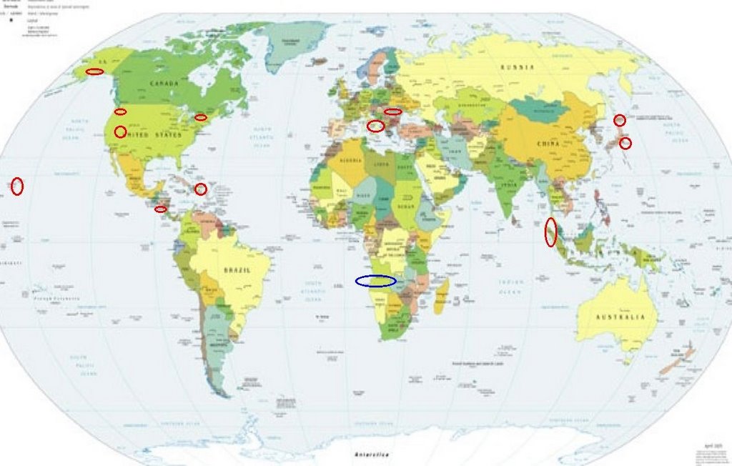
Places to watch.
Good luck to all.
For Friday, 17 November 2006.
--------------------------------------
El Salvador (12.57N 89.30W)
(Second day symptom - Strong)
--------------------------------------
06/11/17 23:56:37 11.43N 85.59W 170.4 4.0ML Cerca del Volcán Maderas
06/11/17 20:21:21 11.79N 88.25W 51.4 3.1ML Oceano Pacífico de Nicaragua
06/11/17 16:00:51 12.17N 87.05W 62.7 2.0ML Frente a Poneloya
06/11/17 12:28:43 8.06N 78.24W 30.0 5.3ML Sismo regional o lejano
06/11/17 04:27:03 10.62N 86.93W 4.1 3.1ML Oceano Pacífico de Nicaragua
06/11/17 03:09:51 10.76N 86.77W 1.0 3.3ML Frente a El Astillero
06/11/17 00:20:49 12.61N 86.81W 1.0 1.5ML Cerca del volcan Telica
Romania (Medium)
--------------------------------------
18Nov2006 16:14:07.7 45.5N 26.6E140 ML=3.6 M ROM ROMANIA
Utah/Nevada (medium)
--------------------------------------
06/11/16 00:10:17 39.72N 110.75W 0.7 1.2 6.1 mi NE of Helper
06/11/16 01:28:59 39.42N 111.22W 4.5 1.7 15.3 mi WNW of Huntington
06/11/16 02:54:56 39.41N 111.22W 5.0 1.7 15.2 mi WNW of Huntington
06/11/16 05:06:52 39.42N 111.22W 2.0 1.9 15.1 mi WNW of Huntington
06/11/16 15:47:59 39.42N 111.22W 1.8 2.1 15.2 mi E of Spring City
06/11/16 23:27:21 39.73N 110.75W 0.3 1.2 6.3 mi NE of Helper
06/11/17 04:27:08 39.42N 111.22W 3.5 1.5 15.2 mi WNW of Huntington
06/11/17 06:22:08 40.74N 112.04W 5.7 2.5 3.7 mi NE of Magna
06/11/17 12:10:57 39.73N 110.74W 0.3 1.7 6.9 mi NE of Helper
1.9 2006/11/16 16:05:34 38.374 -116.454 0.2 22 km ( 13 mi) NNW of Warm Springs, NV
1.9 2006/11/16 08:22:30 38.637 -118.803 13.4 17 km ( 11 mi) ENE of Wichman, NV
1.3 2006/11/16 06:56:12 37.417 -117.082 0.0 20 km ( 13 mi) NE of Tokop, NV
1.6 2006/11/16 04:35:51 37.730 -117.291 2.8 2 km ( 1 mi) WNW of West Spring, NV
1.2 2006/11/16 04:18:36 37.723 -117.301 2.1 3 km ( 2 mi) W of West Spring, NV
1.2 2006/11/17 00:55:59 38.394 -118.685 0.0 16 km (10 mi) SSW of Hawthorne, NV
1.9 2006/11/17 12:14:59 36.141 -115.363 0.0 3 km (2 mi) WNW of Summerlin South, NV
1.8 2006/11/17 18:36:36 37.505 -115.179 15.0 11 km ( 7 mi) SSE of Hiko, NV
1.5 2006/11/17 21:05:25 36.842 -115.899 0.0 36 km (22 mi)NNW of Indian Springs, NV
1.2 2006/11/17 22:08:48 36.842 -115.899 15.0 36 km (22 mi)NNW of Indian Springs, NV
Dominican Republic area(19.294 -68.857)
--------------------------------------
3.2 2006/11/14 16:29:06 18.985N -67.948W 16.1 90 km (56 mi) ENE of Higüey, La Altagracia, Dominican Republic
(2 days early)
Mt. St. Helen’s and surrounding areas
--------------------------------------
1.4 2006/11/17 12:08:42 46.191N 122.194W 0.7 1 km ( 1 mi) SW of Mount St. Helens Volcano, WA
2.3 2006/11/17 09:34:54 45.195N 120.112W 6.7 7 km ( 5 mi) SE of Condon, OR
2.4 2006/11/17 08:25:14 46.198N 122.192W 0.0 1 km ( 1 mi) WSW of Mount St. Helens Volcano, WA
2.0 2006/11/17 00:56:44 46.196N 122.194W 0.5 1 km ( 1 mi) WSW of Mount St. Helens Volcano, WA
Central Italy/Southern Italy
--------------------------------------
2006-11-17 17:59:23.0 39.07N 17.19E 14 ML2.9 SOUTHERN ITALY
Northern Sumatra (4.85N 95.14E)
(Medium)
--------------------------------------
2006-11-17 00:58:00.7 9.73S 108.86E 30 mb5.0 SOUTH OF JAVA, INDONESIA
2006-11-17 09:25:20.4 4.75S 138.24E 30 mb5.1 PAPUA, INDONESIA
Honshu, Japan area
--------------------------------------
2006-11-17 19:44:27.5 28.35N 129.23E 30 mb5.2 RYUKYU ISLANDS, JAPAN
2006-11-17 18:03:09.4 28.57N 130.17E 15 mb5.6 RYUKYU ISLANDS, JAPAN
2006-11-17 12:31:32.7 33.22N 137.32E 339 mb5.3 NEAR S. COAST OF HONSHU, JAPAN
Hokkaido (May go along with Honshu posting)
--------------------------------------
(Nothing found)
Possibly Angola, Africa (This area
of symptoms is giving me as many fits
to figure out as the Pacific Northwest.)
--------------------------------------
2006-11-16 09:36:30 5.4 22.91N 63.23E 20 Owen Fracture Zone Region???
Alaska Peninsula
--------------------------------------
3.5 2006/11/17 05:03:59 56.254 -156.676 100.0 ALASKA PENINSULA
3.5 2006/11/17 22:21:24 54.097 -162.432 1.0 ALASKA PENINSULA
Hawaii
--------------------------------------
2.7 2006/11/17 01:15:54 19.807 -155.936 11.0 12 km ( 7 mi) NE of Kalaoa, HI
Huntingdon, QC area (45.00N 74.42W)
--------------------------------------
2006/11/17 03:07:38 46.86N 66.29W 5.0* 1.8MN 65 km W from Miramichi,NB
Peace to all.

posted by Unknown @ 1:06 PM
1 comments
![]()
![]()
