*For Friday, 19 May 2006.
LEGEND for OVERVIEW: Size = My surety of area for quake.
Red Circle = Probable quake to STRONG quake.
Triangle = Very Strong or Stronger quake (And usually takes extra days).
Blue Circle, etc. = Uncertainty of symptom area for probable quake.
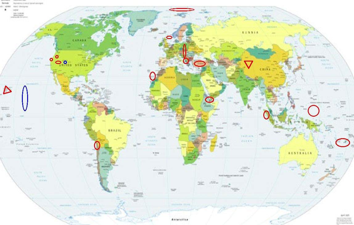
Places to watch.
Good luck to all.
For Friday, 19 May 2006.
----------------------------------------
Western Caroline Islands area (3.0N 132.4E) (Medium)
----------------------------------------
(Nothing found)
XINJIANG, CHINA area (38.47N 80.57E) (I already have this as Very Strong on the 18th - symptoms are continuing off and on but decreasing.)
----------------------------------------
2006-05-19 08:17:03.0 39.47 N 71.83 E ML 3.2 TAJIKISTAN
2006-05-19 14:47:10 5.3 33.94 N 113.47 E Southeastern China
2006-05-19 14:47:31 5.3 28.44 N 101.43 E Sichuan, China
(Off quite a bit on co-ordinates.)
Western Arabian Peninsula area (12.11 N 43.62 E) (Volcanic)
----------------------------------------
2006-05-18 23:37:15.2 34.91 N 43.63 E 29 M 4.2 IRAQ?
Hawaii (VERY STRONG)
http://gatlin.thevisitorcenter.com/pub_gallery/>gatlin

----------------------------------------
MAP 2.7 2006/05/18 11:04:09 19.830 -156.161 49.2 20 km ( 13 mi) NW of Kalaoa, HI
MAP 2.7 2006/05/18 19:00:52 19.470 -154.861 0.7 6 km ( 4 mi) E of Leilani Estates, HI
MAP 1.7 2006/05/20 00:26:34 19.297 -155.220 6.8 17 km ( 11 mi) S of Volcano, HI
Northwestern Balkan Peninsula (41.03 N 22.37 E) (STRONG)
----------------------------------------
2006-05-19 04:17:07.9 44.25 N 17.43 E 10 ML 3.7 NORTHWESTERN BALKAN PEN.
22006-05-19 15:40:22.0 42.41 N 19.74 E 2 ML 3.0 NORTHWESTERN BALKAN PEN.006-05-19 14:00:23.7 46.73 N 14.40 E 2 ML 3.4 NORTHWESTERN BALKAN PEN.
2006-05-20 12:34:29.4 43.20 N 18.85 E ML 3.3 NORTHWESTERN BALKAN PEN.
Poland/Romania/Austria
----------------------------------------
2006-05-17 00:43:16.2 45.51 N 26.55 E 109 ML 2.0 ROMANIA
2006-05-17 04:40:23.0 51.59 N 16.05 E 4 ML 3.7 POLAND
(2 days early)
2006-05-18 00:39:33.9 47.67 N 13.57 E 2 ML 2.5 AUSTRIA
2006-05-19 04:48:54.7 50.02 N 18.51 E 2 ML 2.5 POLAND
2006-05-19 19:49:08.8 50.15 N 18.43 E 10 ML 2.4 POLAND
2006-05-21 10:58:04 4.9 51.47 N 16.08 E Poland
2006-05-21 16:53:20.7 51.47 N 16.14 E ML 2.1 POLAND
(2 extra days)
Petrolia (Medium)
----------------------------------------
MAP 2.2 2006/05/20 02:37:11 40.552 -124.353 15.4 8 km ( 5 mi) WSW of Ferndale, CA
Turkey (38.29 N 30.84 E)
----------------------------------------
2006-05-19 04:49:07.2 39.12 N 36.06 E 5 MD 3.7 TURKEY
2006-05-19 23:02:04 4.4 43.22 N 36.39 E Black Sea
2006-05-19 23:01:59 4.5 42.57 N 36.20 E Black Sea
Medicine Lakes Volcanic area (41.370N 121.433W) (Medium)
----------------------------------------
MAP 2.0 2006/05/19 08:13:53 40.616 -122.393 0.4 5 km ( 3 mi) NNW of Redding, CA
Possibly Colorado or East Pacific Rise (Also posted this for the 17th...should have an idea which place soon.)
----------------------------------------
(I have East Pacific Rise for this symptom posted on the 17th as 3 days early - I will need a repeat for confirmation.)
Tonga/Fiji area
----------------------------------------
2006-05-18 02:41:54.1 23.35 S 179.92 W 500 f mb 4.6 SOUTH OF FIJI ISLANDS
2006-05-18 14:55:55.2 17.15 S 177.91 W 33 mb 5.5 FIJI ISLANDS REGION
2006-05-20 06:55:59.5 20.67 S 174.22 W 33 f mb 4.8 TONGA ISLANDS
2006-05-20 07:33:43.4 20.76 S 174.20 W 33 mb 5.1 TONGA ISLANDS
Canary Islands (26.46N 18.34W) (Indication of depth - Strong)
----------------------------------------
2006-05-22 00:07:40.1 32.57 N 13.22 W 25 f ML 3.5 MADEIRA ISLANDS,PORTUGAL REG
(3 extra days)
North of Svalbard (84.91 N 14.69 E)
----------------------------------------
SVALBARD, NORWAY, REGION
Origin time Lat Lon Azres Timres Wres Nphase Ntot Nsta Netmag
2006-138:21.53.50.0 81.47 28.03 2.85 0.19 0.90 2 3 1 1.97
SVALBARD, NORWAY, REGION
Origin time Lat Lon Azres Timres Wres Nphase Ntot Nsta Netmag
2006-139:14.07.41.0 81.48 9.27 9.12 0.13 2.41 3 3 2 1.34
Oeygarden Fault Zone (60.54 4.55)
----------------------------------------
ROGALAND NORWAY
Origin time Lat Lon Azres Timres Wres Nphase Ntot Nsta Netmag
2006-138:11.28.27.0 58.79 6.65 11.91 3.44 6.42 4 5 3 2.45
WESTERN LOFOTEN BASIN
Origin time Lat Lon Azres Timres Wres Nphase Ntot Nsta Netmag
2006-138:14.23.44.0 68.39 3.04 21.15 0.06 5.34 2 3 1 2.13
WESTERN LOFOTEN BASIN
Origin time Lat Lon Azres Timres Wres Nphase Ntot Nsta Netmag
2006-138:15.18.49.0 70.34 0.90 14.20 0.03 3.58 2 2 1 2.70
SHETLAND-ORKNEY ISLANDS
Origin time Lat Lon Azres Timres Wres Nphase Ntot Nsta Netmag
2006-138:23.20.46.0 60.67 1.03 15.37 3.81 7.66 3 3 2 2.22
Northern Chile area (18.12 S 69.05 W)
----------------------------------------
2006-05-17 08:11:46.0 30.61 S 71.11 W 60 f mb 4.7 NEAR COAST OF CENTRAL CHILE
(2 days early)
MAP 4.7 2006/05/18 18:26:21 -32.417 -71.716 10.0 OFFSHORE VALPARAISO, CHILE
2006-05-20 16:52:29 5.4 23.15 S 69.35 W Northern Chile
Utah
----------------------------------------
MAP 2.6 2006/05/19 09:41:47 40.764 -113.794 5.0 20 km ( 13 mi) E of Wendover, UT
MAP 1.4 2006/05/19 09:36:19 38.472 -112.400 2.4 15 km ( 9 mi) W of Marysvale, UT
Northern Sumatra
----------------------------------------
18May2006 01:01:48.7 0.6N 96.4E 33 mb=5.3 M*GSR OFF W COAST OF NORTHERN SU
2006-05-18 17:35:51.6 0.20 N 97.19 E 60 mb 4.6 NORTHERN SUMATERA, INDONESIA
Peace to all.

posted by Unknown @ 1:49 PM
0 comments
![]()
![]()
