*For Saturday, 28 January 2006.
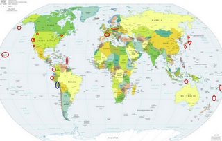
LEGEND for OVERVIEW:
Size = My surety of area for quake.
Red Circle = Probable quake to STRONG quake.
Triangle = Very Strong or Stronger quake (And usually takes extra days).
Blue Circle, etc. = Uncertainty of symptom area for probable quake.

Places to watch.
Good luck to all.
For Saturday, 28 January 2006.
----------------------------------------
South of Panama (6.65 N 82.70 W) (Medium)
----------------------------------------
2006-01-29 17:49:11.5 6.82N 77.61W 2 mb5.4 NEAR WEST COAST OF COLOMBIA
Pinnacles/Parkfield and in between
----------------------------------------
map 2.0 2006/01/28 00:17:55 35.981 -120.546 3.1 14 km ( 9 mi) NW of Parkfield, CA
Near the Coast of Northern Peru (8.28 S 79.97 W) (This may be another symptom for South of Panama or another quake. Not sure but the indication was deep..)
----------------------------------------
(Nothing found)
Timor Region, Indonesia (-10.031 124.379) (STRONG and deep)
----------------------------------------
2006-01-28 21:33:56.3 3.15S 128.35E 58 mb4.7 SERAM, INDONESIA
Central Aleutians and South of
----------------------------------------
(Nothing found)
Southern Nevada near California border
----------------------------------------
map 2.0 2006/01/28 21:33:35 37.417 -117.082 0.0 20 km ( 13 mi) NE of Tokop, NV
Possibly Sabancaya Volcano/Andes Volcano eruption
http://volcano.und.nodak.edu/vwdocs/volc_images/img_sabancaya.html>Volcano
----------------------------------------
(Nothing found)
Ensenada, Mexico
----------------------------------------
(Nothing found)
Hawaii
----------------------------------------
map 2.8 2006/01/28 11:52:20 19.439N 155.294W 4.8 3 km ( 2 mi) NW of Kilauea Summit
map 2.1 2006/01/28 11:47:18 19.402N 155.269W 2.8 2 km ( 1 mi) SSE of Kilauea Summit
map 2.8 2006/01/28 11:45:33 19.406N 155.266W 1.0 2 km ( 1 mi) SE of Kilauea Summit
map 1.8 2006/01/28 11:11:04 19.409N 155.298W 1.4 2 km ( 1 mi) WSW of Kilauea Summit
map 2.1 2006/01/28 05:47:30 19.696N 155.549W 23.4 7 km ( 5 mi) S of Pohakuloa
map 1.8 2006/01/28 20:26:25 19.399N 155.610W 10.7 9 km ( 6 mi) S of Mauna Loa Summit
map 2.9 2006/01/29 22:29:19 19.398N 155.252W 2.7 3 km ( 2 mi) SE of Kilauea Summit
map 1.8 2006/01/29 11:31:43 19.387N 155.249W 2.9 4 km ( 3 mi) SE of Kilauea Summit
map 2.2 2006/01/29 05:06:26 19.416N 155.278W 1.4 0 km ( 0 mi) W of Kilauea Summit
map 1.9 2006/01/29 01:31:58 19.207N 155.454W 0.0 3 km ( 2 mi) E of Pahala
Coso Junction area and North of
----------------------------------------
map 1.9 2006/01/27 12:27:28 36.165 -117.877 3.1 15 km ( 9 mi) NNE of Coso Junction, CA
map 1.3 2006/01/27 20:37:35 35.958 -117.711 3.7 23 km ( 15 mi) ESE of Coso Junction, CA
France
----------------------------------------
2006-01-28 16:22:50.8 46.08N 1.31W 2 ML3.0 FRANCE
Tonga area (-17.945 -173.174) and South of Fiji (25.07 S 178.81 W) (STRONG for South of Fiji)
----------------------------------------
2006-01-29 14:14:44 5.3 17.53 S 177.54 W Fiji Islands Region
2006-01-29 11:43:41 5.7 16.26 S 176.59 W Fiji Islands Region
2006-01-29 08:26:29 5.4 22.85 S 177.66 W South of Fiji Islands
Virgin Islands (Medium)
----------------------------------------
2006/01/28 01:03:54.71 19.319N 67.198W 30.1 3.2 D Puerto Rico Trench
2006/01/28 01:53:42.60 19.298N 67.206W 27.4 2.8 D Puerto Rico Trench
2006/01/28 04:59:53.27 18.990N 67.153W 7.3 2.9 D Northern Puerto Rico
2006/01/28 05:46:44.11 19.089N 64.960W 25.2 3.3 D Sombrero Fault Zone
2006/01/28 20:31:17.91 18.780N 66.797W 8.2 3.3 D Northern Puerto Rico
2006/01/28 22:19:30.73 18.207N 66.539W 71.3 2.9 B Central Puerto Rico
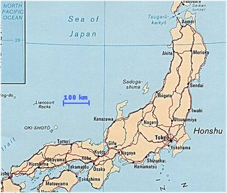
Honshu, Japan (Very Strong)
http://gojapan.about.com/cs/japanmaps/l/blhonshumap.htm?terms=asia+countries+map>Honshu

----------------------------------------
(Nothing found - this is probably still coming.)
Hokkaido, Japan (STRONG)
----------------------------------------
2006-01-26 23:05:09.8 42.8N 146.26 E10mb 5.2 OFF SE.CST OF HOKKAIDO,JAPAN
Kyushu/Ryukyu area (Medium)
----------------------------------------
AP 4.2 2006/01/29 17:15:52 24.662 123.954 84.8 SOUTHWESTERN RYUKYU ISLANDS, JAPAN
Poland/Germany area
----------------------------------------
2006-01-27 13:32:06.9 51.59N 16.29E 10 ML3.0 POLAND
2006-01-28 03:17:44.7 51.40N 15.96E 10 ML2.2 POLAND
Mt. St. Helen's
----------------------------------------
map 2.7 2006/01/29 13:28:18 46.192 -122.189 0.0 1 km ( 1 mi) SW of Mount St. Helens Volcano, WA
Chateaugay, New York (44.979 -73.895) (May be 2 days early)
----------------------------------------
map 1.6 2006/01/31 03:59:32 44.988N 74.434W 8.0 19 km (12 mi) NW of Malone, NY
(3 days late!)
Peace to all.

