*For Thursday, 1 June 2006.
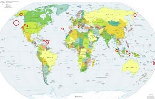
LEGEND for OVERVIEW: Size = My surety of area for quake.
Red Circle = Probable quake to STRONG quake.
Triangle = Very Strong or Stronger quake (And usually takes extra days).
Blue Circle, etc. = Uncertainty of symptom area for probable quake.

Places to watch.
Good luck to all.
For Thursday, 1 June 2006.
----------------------------------------
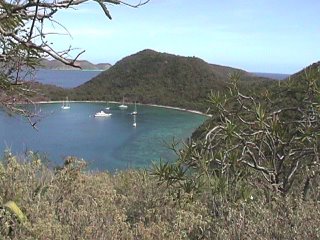
The Virgin Islands then Puerto Rico (VERY STRONG for Virgin Islands and STRONG for Puerto Rico)
http://www.sailantiquity.com/>sailantiquity

----------------------------------------
map 2.4 2006/06/01 19:26:49 18.168N -67.052W 17.2 8 km ( 5 mi) W of Maricao, PR
map 2.7 2006/06/01 14:41:34 19.101N -66.458W 44.6 71 km (44 mi) N of Tierras Nuevas Poniente, PR
map 2.9 2006/06/01 13:26:03 19.112N -66.463W 24.9 72 km (45 mi) N of Tierras Nuevas Poniente, PR
map 2.9 2006/06/01 07:23:57 19.127N -66.450W 29.9 74 km (46 mi) N of Breñas, PR
map 2.8 2006/06/01 07:22:11 18.236N -63.689W 13.3 55 km (34 mi) ESE of West End, Tortola, British Virgin Islands
map 2.9 2006/06/01 06:02:54 19.107N -66.453W 20.0 72 km (45 mi) N of Breñas, PR
map 2.9 2006/06/01 03:22:45 19.075N -66.460W 25.1 68 km (42 mi) N of Tierras Nuevas Poniente, PR
map 2.9 2006/06/01 02:32:55 19.079N -66.449W 25.1 69 km (43 mi) N of Breñas, PR
MAP 3.0 2006/06/01 02:23:26 19.108N -66.455W 21.1 72 km (45 mi) N of Breñas, PR
map 2.7 2006/06/01 02:11:15 19.094N -66.448W 45.5 70 km (44 mi) N of Breñas, PR
MAP 3.1 2006/06/01 01:09:21 19.108N -66.451W 25.2 72 km (45 mi) N of Breñas, PR
MAP 3.2 2006/06/02 23:52:10 18.383N -67.731W 116.1 51 km (32 mi) W of Rincón, PR
MAP 3.0 2006/06/02 07:11:22 19.143N -66.450W 24.5 76 km (47 mi) N of Breñas, PR
MAP 3.2 2006/06/02 04:15:32 18.927N -67.807W 5.1 88 km (54 mi) NW of Rincón, PR
MAP 3.4 2006/06/03 14:46:49 17.972N -65.576W 41.6 17 km (11 mi) SW of Esperanza, PR
map 2.8 2006/06/03 13:56:08 17.998N -67.072W 7.4 4 km ( 2 mi) NW of La Parguera, PR
map 2.0 2006/06/03 07:24:42 17.811N -66.945W 18.7 18 km (11 mi) S of Guánica, PR
(2 extra days)
Southern Nevada/California border area
----------------------------------------
MAP 2.4 2006/06/02 20:34:08 32.664 -115.326 10.0 13 km ( 8 mi) E of Mexicali, Mexico
(Possibly this quake - will have to try to pinpoint this.)
Nothern Sumatra (2 different symptoms - Strong)
----------------------------------------
2006-06-02 21:56:27 5.0 4.09 N 95.61 E Northern Sumatra, Indonesia
Talaud Islands, Indonesia (4.57N 125.42E)
----------------------------------------
2006-06-01 05:46:39.7 1.29 N 128.13 E 110 f mb 5.0 HALMAHERA, INDONESIA
Utah/Nevada
----------------------------------------
MAP 1.5 2006/06/01 04:41:11 39.728 -110.747 1.3 10 km ( 6 mi) ENE of Helper, UT
Banda sea area (6.0S 128.3E)
----------------------------------------
2006-06-01 05:46:44 5.3 1.29 N 128.23 E Halmahera, Indonesia
(Should have combined the 2 symptoms that were so close.)
Azores area in the North Atlantic (Medium)
----------------------------------------
2006-05-31 08:19:27.0 40.58 N 29.25 W 10 ML 3.1 AZORES ISLANDS REGION
Tonga and North of (Strong)
----------------------------------------
2006-05-31 12:37:53.5 17.34 S 178.19 W 250 f mb 4.7 FIJI ISLANDS REGION
2006-06-01 22:31:23 5.6 19.96 S 173.75 W Tonga Islands
2006-06-02 06:59:40.7 20.07 S 173.81 W 33 mb 5.0 TONGA ISLANDS
2006-06-02 03:26:40.4 21.20 S 174.31 W 33 mb 5.2 TONGA ISLANDS
2006-06-02 01:28:27.2 20.06 S 173.82 W 33 mb 5.3 TONGA ISLANDS
2006-06-02 07:31:33.9 20.61 S 178.74 W 560 fmb 5.9 FIJI ISLANDS REGION
2006-06-02 11:12:50.9 19.85 S 174.17 W 33 mb 4.9 TONGA ISLANDS
Italy (Strong)
----------------------------------------
2006-06-01 02:43:44.0 42.68 N 15.81 E 7 ML 2.7 ADRIATIC SEA
2006-06-01 06:29:33.0 43.80 N 11.95 E 3 ML 2.8 CENTRAL ITALY
2006-06-01 06:12:00.0 43.79 N 11.93 E 3 ML 2.2 CENTRAL ITALY
Moraga, California area (37.806 -122.077) (As usual, I worry about exaggerated symptoms for California but I am putting this at - STRONG.)
----------------------------------------
MAP 1.3 2006/06/01 03:37:56 37.751 -122.135 3.9 5 km ( 3 mi) NNE of San Leandro, CA
MAP 1.3 2006/06/01 15:07:55 37.205 -122.115 10.7 8 km ( 5 mi) N of Boulder Creek, CA
MAP 1.3 2006/06/01 17:33:05 37.809 -122.066 10.4 6 km ( 4 mi) SSW of Alamo, CA
MAP 1.3 2006/06/01 18:54:53 37.020 -122.138 6.5 8 km ( 5 mi) WSW of Felton, CA
Mt. St. Helen’s
----------------------------------------
MAP 1.6 2006/06/01 05:04:24 46.195 -122.198 0.8 1 km ( 1 mi) WSW of Mount St. Helens Volcano, WA
MAP 1.6 2006/06/01 14:06:00 46.196 -122.197 1.2 1 km ( 1 mi) WSW of Mount St. Helens Volcano, WA
06/03/01 09:29:03 46.20N 122.17W 0.0 2.6 BC 1.0 km ENE of Mt St Helens,
06/03/01 21:04:18 46.20N 122.19W 0.0 2.4 DC 0.9 km NW of Mt St Helens,
MAP 1.5 2006/06/02 13:22:37 46.196 -122.197 0.7 1 km ( 1 mi) WSW of Mount St. Helens Volcano, WA
06/03/02 12:45:32 46.20N 122.18W 0.0 2.1 DB 0.7 km NNE of Mt St Helens,
06/03/02 23:47:17 46.20N 122.20W 1.1 2.4 BC 1.1 km WNW of Mt St Helens,
Possibly North Pacific (45N 150W) (New symptom) (STRONG)
----------------------------------------
(Nothing found)
Cambria, California area (35.641 -121.076)
----------------------------------------
MAP 2.1 2006/06/01 22:29:05 35.624 -120.990 5.1 12 km ( 7 mi) NE of Cambria, CA
Eastern Siberia, Russia area (60.96 N 165.63 E) (MEDIUM)
----------------------------------------
(Nothing found)
Southern Alaska
----------------------------------------
MAP 3.2 2006/06/01 00:02:27 59.848 -153.093 100.0 SOUTHERN ALASKA
Peace to all.

