*For Friday, 9 June 2006.
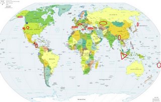
LEGEND for OVERVIEW: Size = My surety of area for quake.
Red Circle = Probable quake to STRONG quake.
Triangle = Very Strong or Stronger quake (And usually takes extra days).
Blue Circle, etc. = Uncertainty of symptom area for probable quake.

Places to watch.
Good luck to all.
For Friday, 9 June 2006.
----------------------------------------
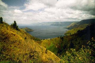
Northern to Southern Sumatra (2nd day of symptoms - Extremely Strong. As strong as this is it could take 5 or more extra days.)
http://home.s-planet.de/stefan.meivers/Bilder_HTML/Indonesien/bild64.html>home.s-planet

----------------------------------------
2006-06-08 04:23:22.8 2.60 N 97.03 E 53 mb 5.0 NORTHERN SUMATERA, INDONESIA
Sicily, Italy/Ionian Sea
----------------------------------------
2006-06-09 11:11:50.9 40.16 N 19.76 E 64 ML 3.1 ALBANIA
Turkey
----------------------------------------
2006-06-08 07:18:01.8 39.10 N 27.53 E 18 MD 2.9 TURKEY
2006-06-08 10:37:12.2 39.19 N 27.64 E 6 MD 2.8 TURKEY
2006-06-08 09:34:06.9 39.22 N 28.12 E 28 MD 2.9 TURKEY
2006-06-08 08:41:32.5 37.44 N 38.86 E 26 MD 3.0 TURKEY
2006-06-09 13:50:48.0 38.57 N 36.00 E 5 MD 3.1 TURKEY
2006-06-09 15:01:21.4 39.75 N 40.66 E 5 MD 3.5 TURKEY
2006-06-09 15:57:51.8 41.49 N 35.95 E 8 MD 2.9 TURKEY
2006-06-09 19:03:07.1 37.59 N 43.61 E 29 MD 3.0 TURKEY
2006-06-09 18:43:44.6 37.62 N 43.54 E 6 MD 3.1 TURKEY
2006-06-09 18:21:56.6 37.64 N 43.74 E 18 MD 3.4 TURKEY
2006-06-09 18:01:25.6 37.83 N 43.49 E 10 mb 4.3 TURKEY
2006-06-09 20:53:07.4 39.67 N 39.00 E 22 MD 3.7 TURKEY
2006-06-09 21:32:22.3 37.61 N 43.94 E 29 MD 3.1 TURKEY
2006-06-09 21:49:13.7 37.63 N 43.68 E 23 MD 3.5 TURKEY
Guatamala area then Nicaragua/Costa Rica area (Both areas - MEDIUM)
----------------------------------------
MAP 4.4 2006/06/09 04:21:02 6.033 -82.598 20.7 SOUTH OF PANAMA
MAP 4.3 2006/06/09 14:12:49 12.580 -89.237 82.2 OFFSHORE EL SALVADOR
Tonga (Medium)
----------------------------------------
2006-06-08 14:58:41.6 19.81 S 177.89 W 33 mb 5.6 FIJI ISLANDS REGION
2006-06-09 05:58:25.2 17.39 S 178.87 W 540 f mb 5.8 FIJI ISLANDS REGION
2006-06-09 09:31:03.0 25.39 S 179.65 E 475 mb 5.0 SOUTH OF FIJI ISLANDS
2006-06-09 10:40:34.3 18.02 S 178.49 W 500 mb 5.5 FIJI ISLANDS REGION
2006-06-09 16:01:42.7 15.12 S 172.76 W 45 G M 4.6 SAMOA ISLANDS REGION
Pyrenees/France-Spain border area then Pyrenees/Portugal side
----------------------------------------
2006-06-08 07:53:58.2 39.12 N 2.69 W 2 ML 2.8 SPAIN
2006-06-08 19:06:29.0 40.45 N 5.65 W 11 ML 2.0 SPAIN
Mammoth Lakes/Tom’s Place (medium)
----------------------------------------
MAP 1.0 2006/06/09 08:15:22 37.467 -118.784 10.3 14 km ( 9 mi) SW of Toms Place, CA
MAP 2.1 2006/06/09 22:55:30 37.575 -118.839 2.1 14 km ( 9 mi) ESE of Mammoth Lakes, CA
MAP 1.5 2006/06/09 23:45:07 37.570 -118.845 1.6 14 km ( 9 mi) ESE of Mammoth Lakes, CA
MAP 1.9 2006/06/09 23:57:04 37.569 -118.846 1.5 14 km ( 9 mi) ESE of Mammoth Lakes, CA
Switzerland/Northern Italy/France area (STRONG)
----------------------------------------
2006-06-09 06:18:35.0 45.23 N 10.48 E 346 ML 3.0 NORTHERN ITALY
Utah (medium)
----------------------------------------
MAP 1.7 2006/06/09 04:29:37 39.610 -110.392 1.0 6 km ( 4 mi) N of Sunnyside, UT
MAP 1.5 2006/06/09 06:59:11 39.458 -111.207 5.6 23 km ( 15 mi) ESE of Mount Pleasant, UT
MAP 1.4 2006/06/09 09:53:45 39.455 -111.217 12.0 23 km ( 14 mi) ESE of Mount Pleasant, UT
http://msnbc.msn.com/id/13318067/
Yellowstone geyser erupts for 1st time in 8 years
Eruption coincides with 'thermal disturbance' at Norris Geyser Basin
Related Stories
---------
Powered by WeatherBug
Updated: 12:23 a.m. ET June 14, 2006
A large geyser that hadn't erupted since 1998 surprised two hikers near the edge of Yellowstone National Park's Norris Geyser Basin with a roar and burst of steam. Lee Whittlesey and Betsy Watry heard the Ledge geyser before they saw it. "It was like a jet plane," Whittlesey said.
The geyser erupted at full bore around 5 p.m. Saturday, sending a plume of steam about 100 feet high. "I've been in the park 30 years, and this was the first time I'd seen Ledge erupt," said Whittlesey, who is Yellowstone's historian. "Now I can check that one off."
Watry, who works for the Yellowstone Association, said they were shocked at the show that unfolded about a quarter-mile away.
Kazakhstan area (47.20N 64.35E) (Second day symptom - Strong)
----------------------------------------
(Nothing found)
San Francisco Bay area
----------------------------------------
MAP 2.6 2006/06/09 14:53:21 38.045 -122.142 7.6 2 km ( 2 mi) SSE of Benicia, CA
MAP 1.4 2006/06/10 07:29:44 37.883 -122.260 9.6 2 km ( 1 mi) NE of Berkeley, CA
MAP 1.0 2006/06/10 13:33:52 37.875 -122.256 8.9 2 km ( 1 mi) ENE of Berkeley, CA
Alaska Peninsula
----------------------------------------
MAP 3.4 2006/06/09 20:07:05 59.548 -149.211 40.0 KENAI PENINSULA, ALASKA
Myanmar area (medium)
----------------------------------------
(Nothing found)
Possibly Kittitas, Washington area (47.023N 120.280W) (Unproven Symptom)
----------------------------------------
MAP 1.3 2006/06/09 03:08:42 47.837 -122.544 24.9 5 km ( 3 mi) NW of Kingston, WA
MAP 1.0 2006/06/09 08:07:07 47.346 -122.643 14.3 5 km ( 3 mi) WNW of Gig Harbor, WA
MAP 1.7 2006/06/09 23:54:53 48.435 -122.185 0.0 5 km ( 3 mi) SE of Clear Lake, WA
MAP 2.4 2006/06/11 02:26:34 48.227 -121.681 8.6 6 km ( 4 mi) WSW of Darrington, WA
MAP 1.2 2006/06/11 07:39:12 48.834 -122.181 0.0 4 km ( 2 mi) E of Deming, WA
MAP 2.0 2006/06/11 07:35:48 48.829 -122.171 0.0 4 km ( 3 mi) E of Deming, WA
(2 extra days)
The Kurils
----------------------------------------
2006-06-10 22:31:01.4 46.06 N 152.62 E 60 mb 4.8 KURIL ISLANDS, RUSSIA
Peace to all.

