*For Friday, 29 December 2006.
LEGEND for OVERVIEW: Size = My surety of area for quake.
Red Circle = Probable quake to STRONG quake.
Triangle = Very Strong/Stronger quake (Usually takes extra days).
Blue Circle, etc. = Uncertainty of symptom area for probable quake.
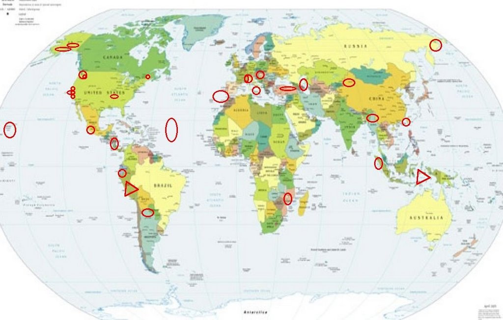
Places to watch.
(Very busy days ahead!)
Good luck to all.
For Friday, 29 December 2006.
--------------------------------------
Caspian Sea area (37.63N 49.09E)
(Strong)
then Turkey
--------------------------------------
2006-12-28 22:52:19.8 41.28N 43.84E 2 ML3.6 GEORGIA (SAK'ART'VELO)
2006-12-28 02:44:13.1 40.62N 33.05E 11 MD2.9 CENTRAL TURKEY
2006-12-28 20:36:23.9 39.38N 33.12E 5 MD3.0 CENTRAL TURKEY
2006-12-28 23:05:53.8 38.34N 30.44E 4 MD2.9 WESTERN TURKEY
2006-12-29 14:21:00.4 39.91N 38.78E 9 MD2.8 EASTERN TURKEY
2006-12-29 14:11:20.1 37.31N 28.37E 24 MD2.8 WESTERN TURKEY
2006-12-29 10:58:40.4 37.27N 28.21E 5 MD2.8 WESTERN TURKEY
2006-12-29 10:03:34.1 37.27N 28.21E 3 MD2.8 WESTERN TURKEY
2006-12-29 04:23:02.1 40.57N 34.51E 3 MD2.8 CENTRAL TURKEY
2006-12-29 04:03:56.6 39.36N 28.14E 2 MD3.0 WESTERN TURKEY
2006-12-29 02:14:00.6 44.10N 13.47E 5 ML3.0 ADRIATIC SEA
2006-12-29 02:03:33.9 39.84N 41.85E 5 MD3.2 EASTERN TURKEY
2006-12-29 00:00:00.0 41.02N 44.05E ML3.5 ARMENIA
Mozambique (Medium)
--------------------------------------
(Nothing found)
Parkfield Fault/Pinnacles area
--------------------------------------
1.0 2006/12/28 16:02:54 36.940 -121.561 6.2 8 km ( 5 mi) SSE of Gilroy, CA
1.4Q 2006/12/29 19:47:26 36.754 -121.584 3.1 1 km ( 1 mi) NE of Quarry near Natividad, CA(Probable quarry explosion)
Southern Italy/Sicily area
(Strong)
then Northern Italy/France area
--------------------------------------
2006-12-29 06:23:31.0 41.86N 15.55E ML2.9 SOUTHERN ITALY
(Not strong but had a lot of symptoms.)
MYANMAR-INDIA BORDER REGION
(23.39N 94.32E) (Medium)
--------------------------------------
(Nothing found)
Maine area (44.33N 68.16W)
(2 different symptoms - Strong)
--------------------------------------
Region: MAINE
Geographic coordinates: 44.420N, 68.230W
Magnitude: 3.5M
Depth: 2 km
Universal Time (UTC): 29 Dec 2006 21:21:11
The New Madrid Fault (2 different
symptoms - Strong)
--------------------------------------
1.7 2006/12/29 06:34:45 36.310 -89.510 7.6 6 km ( 3 mi) NNW of Ridgely, TN
(Symptom was strong - quake was not.)
Woodside, California area (37.393 -122.266)
(Indication of depth - Strong)
--------------------------------------
1.9 2006/12/29 03:23:47 37.956 -122.314 9.4 1km(1 mi) N of East Richmond Heights, CA
2.1 2006/12/29 05:44:33 37.858 -122.233 9.7 4km(2 mi) ESE of Berkeley, CA
Peruvian Volcano eruption (Probably Ubinus
which is erupting continually but
I don’t really know which one - Very Strong)
www.reliefweb.int

--------------------------------------
www.reliefweb.int
www.volcanodiscovery.com
( Ubinas volcano (Peru), activity update: continuing moderate explosive activity
Thursday 04. of January 2007 Age: 9 hrs
Based on pilot reports, the Buenos Aires VAAC reported continuous emissions from Ubinas on 27 and 30 December. Ash plumes rose to 4.9-8.5 km (16,000-28,000 ft) a.s.l. and drifted E.)
Washington State/Greenwater area and
then close to the coast and Canada and
then Mt. St. Helen’s (Still have not been
able to pinpoint anything except Mt. St. Helen’s.)
--------------------------------------
1.8 2006/12/29 00:52:48 46.855 -121.599 6.2 32 km ( 20 mi) S of Greenwater, WA
1.8 2006/12/29 04:28:17 46.502 -122.315 21.8 7 km ( 4 mi) SSW of Morton, WA
1.2 2006/12/29 11:07:33 46.199 -122.198 0.0 1 km ( 1 mi) W of Mount St. Helens Volcano, WA
1.2 2006/12/29 11:57:16 44.161 -121.921 7.6 33 km ( 20 mi) WSW of Sisters, OR
1.1 2006/12/29 20:20:30 46.199N 122.189W 0.0 1 km ( 0 mi) WSW of Mount St. Helens Volcano, WA
1.5 2006/12/29 14:11:51 46.197N 122.189W 0.0 1 km ( 1 mi) WSW of Mount St. Helens Volcano, WA
1.1 2006/12/29 13:42:23 48.232N 120.584W 7.3 37 km (23 mi) WSW of Twisp, WA
Nicaragua/Costa Rica
--------------------------------------
06/12/28 18:58:10 11.59N 86.15W 124.9 2.8ML Carazo
06/12/28 18:33:47 11.00N 86.39W 15.3 2.9ML Frente a San Juan del Sur
06/12/28 13:51:44 11.60N 87.16W 15.4 3.1MC Frente a Puerto Sandino
06/12/28 03:20:23 12.31N 87.07W 26.0 2.6MC Frente a Poneloya
France (45.00N 6.64E)
--------------------------------------
2006-12-29 22:39:21.4 48.13N 2.62E 10 ML2.7 FRANCE
2006-12-30 19:11:35.8 45.29N 5.37E 10 ML2.9 FRANCE
Northeastern Siberia
--------------------------------------
(Posted on 30th)
Leilani Estates, HI area
(19.484 -154.893)
(2 different symptoms - Strong)
--------------------------------------
2.2 2006/12/29 01:24:21 19.302 -155.388 3.8 15 km ( 9 mi) NE of Pahala, HI
1.9 2006/12/29 06:21:45 19.770 -155.565 9.7 30 km ( 19 mi) SSE of Waimea, HI
NORTHERN XINJIANG, CHINA area
(43.09N 82.85E)
--------------------------------------
2006-12-28 09:27:57.0 48.98N 85.05E ML3.2 KAZAKHSTAN-XINJIANG BORDER REG.
2006-12-29 23:58:50.0 49.36N 79.68E M6.1 EASTERN KAZAKHSTAN
2006-12-30 08:01:32.0 42.79N 81.53E ML3.0 NORTHERN XINJIANG, CHINA
TAIWAN REGION (21.92N 120.46E)
--------------------------------------
28Dec2006 16:51:17.8 22.0N 120.6E 33 mb=5.0 M*GSR TAIWAN
Alaska Peninsula
--------------------------------------
3.2 2006/12/30 16:20:31 56.442 -155.309 15.0 ALASKA PENINSULA
San Simeon area (35.671 -121.087)
--------------------------------------
1.8 2006/12/29 19:22:53 35.567 -120.975 8.5 10 km ( 6 mi) E of Cambria, CA
Strait of Gibraltar
--------------------------------------
2006-12-30 21:17:18.0 36.59N 7.67W 34 mb3.4 STRAIT OF GIBRALTAR
Seram, Indonesia (3.68S 128.44E)
(VERY STRONG)
www.landofvos.com

--------------------------------------
2006-12-30 04:18:49 4.8mb 3.84N 124.03E 600 Celebes Sea
(Nothing big and may not be the right quake for the symptoms.)
2007-01-03 01:19:59 4.6mb 7.19S 129.38E 146 Banda Sea
2007-01-03 09:33:49 5.1mb 2.26N 128.68E 256 Halmahera, Indonesia
(These may be the right quakes - 5 extra days)
JUJUY, ARGENTINA area
(-23.879 -66.601)
(May be weather - new symptom
for this area that was very light)
--------------------------------------
(Nothing found)
Ecuador (-3.4596 -78.9335)
--------------------------------------
4.4 2006/08/30 10:58 2006/08/30 15:58 -2.0174 -77.4263 12.00
4.0 2006/08/28 19:19 2006/08/29 00:19 -2.8258 -78.8576 10.66
4.0 2006/08/28 00:01 2006/08/28 05:01 -2.3526 -77.0385 137.57
North Atlantic (20N 45W)
--------------------------------------
2006-12-29 21:44:32.1 45.92N 26.56W 10 mb4.4 NORTHERN MID-ATLANTIC RIDGE
NORTHERN SUMATERA, INDONESIA
(0.90N 98.21E)
--------------------------------------
(Nothing found)
CZECH AND SLOVAK REPUBLICS
(50.48N 13.56E)
--------------------------------------
29Dec2006 22:13:00.7 50.0N 18.3E 10 ML=2.5 M*ROM CZECH AND SLOVAK REPUBLICS
Chiapas, Mexico
--------------------------------------
2006/12/28 06:53:14 18.59 102.72 56 3.9 50 km al SURESTE de COALCOMAN, MICH
2006/12/28 17:17:36 16.96 95.57 97 3.7 57 km al OESTE de MATIAS ROMERO, OAX
2006/12/29 06:38:52 18.17 103.36 5 3.7 70 km al SUROESTE de COALCOMAN, MICH
Southern Alaska
--------------------------------------
2.7 2006/12/30 02:58:37 61.993 -151.094 50.0 SOUTHERN ALASKA
3.7 2006/12/30 02:39:43 59.845 -153.142 160.0 SOUTHERN ALASKA
2.5 2006/12/30 15:03:52 61.539 -151.822 15.0 SOUTHERN ALASKA
2.5 2006/12/30 15:27:20 60.302 -152.522 100.0 SOUTHERN ALASKA
San Francisco Bay area (MEDIUM)
--------------------------------------
1.9 2006/12/29 03:23:47 37.956 -122.314 9.4 1 km ( 1 mi) N of East Richmond Heights, CA
2.1 2006/12/29 05:44:33 37.858 -122.233 9.7 4 km ( 2 mi) ESE of Berkeley, CA
(Also posted above - should have combined the 2 symptoms)
Peace to all.

posted by Unknown @ 3:27 PM
0 comments
![]()
![]()
