*For Sunday, 29 October 2006.
LEGEND for OVERVIEW: Size = My surety of area for quake.
Red Circle = Probable quake to STRONG quake.
Triangle = Very Strong/Stronger quake (Usually takes extra days).
Blue Circle, etc. = Uncertainty of symptom area for probable quake.
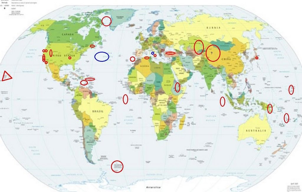
Places to watch.
Good luck to all.
For Sunday, 29 October 2006.
--------------------------------------
South Indian Ocean (9.73S 91.62E)
(Unproven symptom)
--------------------------------------
2006-10-29 14:35:25 4.6 2.49N 98.85E 132 Northern Sumatra, Indonesia
2006-10-29 16:58:43 4.9 55.13S 2.25E 36 Bouvet Island Region
Eastern New Guinea, P.N.G. area
(5.56S 146.94E) (STRONG)
--------------------------------------
2006-10-30 04:29:19.1 6.45S 154.90E 60 mb5.3 BOUGAINVILLE REGION, P.N.G.
2006-11-02 05:17:04.8 5.44S 153.71E 80 mb5.5 NEW IRELAND REGION, P.N.G.
(4 extra days)
Mariana Islands area
--------------------------------------
30Oct2006 14:36:43.2 15.3N 145.5E 90 mb=4.6 M GSR MARIANA ISLANDS
Vanuatu (15S 167E) (May be 2 days early)
--------------------------------------
2006-10-30 00:47:01 5.2 10.98S 156.16E 300 South of Solomon Islands
2006-10-30 04:29:16 5.5 6.51S 154.97E 20 Solomon Islands
South Sandwich Islands area
(60.99 S 25.24 W)
(Second day symptoms - STRONG)
--------------------------------------
(Nothing found)
Ethiopia area (11.49N 43.44E)
--------------------------------------
01Nov2006 22:31:21.3 6.0N 37.0E 10 mb=4.8 M GSR ETHIOPIA
(4 extra days)
The New Madrid Fault
--------------------------------------
1.4 2006/10/29 21:08:18 36.270N 89.500W 7.0 1 km ( 1 mi) NW of Ridgely, TN
Hawaii (2 different symptoms with
charley horse - Very Strong)
decadevolcano.net
--------------------------------------
2.1 2006/10/29 20:28:05 20.102 -155.901 12.3 17 km ( 11 mi) SSW of Hawi, HI
2.1 2006/10/29 08:04:38 19.402 -155.422 10.2 20 km ( 13 mi) WSW of Volcano, HI
2.2 2006/10/29 03:06:13 19.844 -155.606 0.0 21 km ( 13 mi) SSE of Waimea, HI
2.3 2006/10/29 01:13:20 20.419 -156.327 7.0 32 km ( 20 mi) SSE of Wailea-Makena, HI
ASCENSION ISLAND area (-1.828 -15.123)
--------------------------------------
(Nothing found)
West of Gibraltar (36.55N 9.43W)
--------------------------------------
(Nothing found)
Kazakhstan to Kyrgyzstan
--------------------------------------
2006-10-29 09:42:22.0 41.02N 53.35E ML3.4 TURKMENISTAN
2006-10-30 02:47:04.0 45.14N 81.86E ML4.1 KAZAKHSTAN-XINJIANG BORDER REG.
2006-10-30 03:20:20.0 41.53N 73.52E ML3.1 KYRGYZSTAN
The Geysers (Strong)
--------------------------------------
1.1 2006/10/28 01:04:16 38.821 -122.809 2.9 3 km ( 2 mi) N of The Geysers, CA
1.7 2006/10/28 09:37:08 38.823 -122.802 2.1 3 km ( 2 mi) N of The Geysers, CA
1.9 2006/10/28 23:57:25 38.825 -122.804 0.9 3 km ( 2 mi) N of The Geysers, CA
1.0 2006/10/29 00:07:09 38.827 -122.794 2.6 3 km ( 2 mi) NNE of The Geysers, CA
1.4 2006/10/29 00:10:16 38.859 -122.806 0.0 7 km ( 4 mi) N of The Geysers, CA
New Idria, California (36.393 -120.765)
--------------------------------------
1.3 2006/10/29 00:44:59 36.052 -120.580 5.6 22 km ( 13 mi) NW of Parkfield, CA
Lake Tahoe area
--------------------------------------
(Nothing found)
Baffin Bay/Greenland area (Strong)
--------------------------------------
GREENLAND SEA
Origin time Lat Lon Azres Timres Wres Nphase Ntot Nsta Netmag
2006-301:04.37.21.0 78.49 -4.04 1.95 0.14 0.62 2 2 1 1.92
GREENLAND SEA
Origin time Lat Lon Azres Timres Wres Nphase Ntot Nsta Netmag
2006-301:19.42.53.0 74.97 -3.49 9.30 0.33 2.65 2 2 1 2.13
Guadalupe Victoria, Mexico area (Medium)
--------------------------------------
2.7 2006/10/30 22:16:56 32.381 -115.795 7.4 43 km ( 27 mi) SW of Mexicali, Mexico
Honshu, Japan
--------------------------------------
2006-10-29 08:31:53.3 29.59N 140.14E 80 mb5.4 IZU ISLANDS, JAPAN REGION
Northern Algeria area (35.28N 1.35W)
(Unproven symptom)
--------------------------------------
28Oct2006 13:52:15.0 35.6N 0.2E 30 mb=4.6 A*ROM NORTHERN ALGERIA
Possibly Northern Mid-Atlantic (New symptom)
--------------------------------------
(Came in 30th and 31st)
The Parkfield Fault/Pinnacles (Second day
symptom - Strong)
--------------------------------------
1.2 2006/10/29 10:54:40 36.960 -121.591 4.0 6 km ( 4 mi) S of Gilroy, CA
1.9 2006/10/29 15:44:30 36.688 -121.318 4.3 11 km ( 7 mi) S of Tres Pinos, CA
1.3 2006/10/29 21:21:38 36.918 -121.387 8.6 8 km ( 5 mi) N of Hollister, CA
1.0 2006/10/29 21:55:18 35.936 -120.484 5.0 6 km ( 4 mi) NW of Parkfield, CA
Turkey (medium)
--------------------------------------
2006-10-28 15:28:26.5 40.64N 29.23E 6 ML3.3 WESTERN TURKEY
2006-10-28 16:53:07.8 40.63N 29.25E 19 MD3.0 WESTERN TURKEY
2006-10-28 20:35:59.2 40.65N 29.23E 6 MD3.1 WESTERN TURKEY
Puerto Rico/Virgin Islands and down
into the Carribean Sea area
--------------------------------------
2.7 2006/10/29 16:51:44 18.159N -67.358W 17.7 20 km (13 mi) WNW of Puerto Real, PR
3.3 2006/10/29 06:27:40 19.146N -66.918W 10.5 73 km (45 mi) N of Isabela, PR
2.9 2006/10/29 05:01:07 19.055N -66.926W 8.2 63 km (39 mi) N of Isabela, PR
3.5 2006/10/29 04:45:53 19.152N -66.966W 14.9 73 km (45 mi) N of Isabela, PR
2.6 2006/10/29 04:45:09 19.087N -66.969W 21.3 66 km (41 mi) N of Isabela, PR
2.8 2006/10/29 04:43:04 19.095N -66.992W 46.7 66 km (41 mi) N of Isabela, PR
3.2 2006/10/29 03:56:33 19.535N -65.863W 63.7 123 km (76 mi) N of Suárez, PR
2.6 2006/10/29 02:44:12 17.864N -66.942W 5.1 12 km ( 8 mi) S of Guánica, PR
3.0 2006/10/29 01:09:07 19.033N -64.629W 21.2 47 km (29 mi) NW of Settlement, Anegada, British Virgin Islands
San Gorgonio, California (34.122 -116.823)
--------------------------------------
1.4 2006/10/29 04:44:39 34.167 -116.782 5.5 9 km(5 mi) NNE of Mt. San Gorgonio, CA
1.7 2006/10/29 09:04:10 34.156 -116.430 5.5 4 km ( 2 mi) NNW of Yucca Valley, CA
1.4 2006/10/29 13:02:26 34.156 -116.427 6.8 3 km ( 2 mi) NNW of Yucca Valley, CA
1.5 2006/10/29 13:13:02 34.154 -116.424 6.7 3 km ( 2 mi) NNW of Yucca Valley, CA
1.5 2006/10/29 22:03:36 34.162 -116.433 9.4 4 km ( 3 mi) NNW of Yucca Valley, CA
CHARLEVOIX SEISMIC ZONE, QUE. area
(47.75N 69.72W) (Second day symptom -
Strong)
--------------------------------------
2006/10/30 19:31:51 46.46N 75.41W 18.0* 1.9MN 12 km SE from Mont-Laurier,QC
2006/10/30 05:03:02 46.73N 75.82W 18.0* 1.1MN 28 km W from Ferme-Neuve,QC
2006/10/31 02:41:41 47.62N 70.18W 14.4 3.0MN Felt CHARLEVOIX SEISMIC ZONE,QC.
Possibly Mt. Stromboli (New symptom)
--------------------------------------
(Nothing found)
Sicily, Italy (38.14N 15.19E)
--------------------------------------
2006-10-29 03:16:15.0 43.05N 13.52E 24 ML2.6 CENTRAL ITALY
2006-10-29 23:55:21.0 38.64N 14.51E 191 ML3.1 SICILY, ITALY
2006-10-30 12:45:57.0 38.95N 15.49E 224 ML3.2 SICILY, ITALY
Utah/Nevada
--------------------------------------
(Probably were some but they scrolled off and are really very hard to find in archives. Sorry.)
NORTHERN XINJIANG, CHINA (48.85N 87.86E)
(This may be a large area because the symptom
was a spasm vibration and not sure what this will
manifest as but I am putting it at - STRONG)
--------------------------------------
2006-10-30 02:47:04.0 45.14N 81.86E ML4.1 KAZAKHSTAN-XINJIANG BORDER REG.
Peace to all.

posted by Unknown @ 7:09 PM
1 comments
![]()
![]()
