*For Wednesday, 1 March 2006.
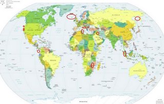
LEGEND for OVERVIEW:
Size = My surety of area for quake.
Red Circle = Probable quake to STRONG quake.
Triangle = Very Strong or Stronger quake (And usually takes extra days).
Blue Circle, etc. = Uncertainty of symptom area for probable quake.

Places to watch.
Good luck to all.
For Wednesday, 1 March 2006.
----------------------------------------
Mozambique
----------------------------------------
MAP 4.4 2006/03/01 03:16:04 -21.058 32.984 10.0 MOZAMBIQUE
The Geysers (medium)
----------------------------------------
MAP 2.0 2006/03/01 01:25:46 38.798 -122.809 4.5 0 km ( 0 mi) W of The Geysers, CA
MAP 1.8 2006/03/01 10:22:20 38.815 -122.812 3.2 2 km ( 1 mi) NNW of The Geysers, CA
MAP 1.9 2006/03/01 12:17:06 38.815 -122.842 2.1 4 km ( 2 mi) WNW of The Geysers, CA
MAP 1.8 2006/03/01 13:01:03 38.835 -122.861 1.7 6 km ( 4 mi) NW of The Geysers, CA
MAP 1.8 2006/03/01 17:01:43 38.831 -122.796 2.1 4 km ( 2 mi) NNE of The Geysers, CA
MAP 1.5 2006/03/01 21:29:12 38.798 -122.809 4.6 0 km ( 0 mi) W of The Geysers, CA
Petrolia and North of
----------------------------------------
MAP 3.3 2006/03/02 04:53:30 40.482 -125.525 2.5 106 km ( 66 mi) W of Petrolia, CA
Hollister to Tres Pinos, California
----------------------------------------
MAP 1.9 2006/03/01 03:16:25 36.533 -121.100 8.6 4 km ( 2 mi) E of Pinnacles, CA
MAP 3.2 2006/03/02 00:11:55 36.555 -121.148 7.6 3 km ( 2 mi) N of Pinnacles, CA
MAP 3.2 2006/03/02 00:11:55 36.555 -121.148 7.6 3 km ( 2 mi) N of Pinnacles, CA
MAP 1.7 2006/03/02 04:50:42 36.961 -121.587 6.1 6 km ( 4 mi) S of Gilroy, CA
MAP 2.2 2006/03/02 14:08:51 35.642 -121.074 4.1 10 km ( 6 mi) N of Cambria, CA
MAP 1.8 2006/03/02 16:13:08 36.586 -121.225 9.0 9 km ( 6 mi) NW of Pinnacles, CA
MAP 1.8 2006/03/02 16:39:41 35.641 -121.076 3.9 10 km ( 6 mi) N of Cambria, CA
Sumatra
----------------------------------------
2006-03-01 14:36:04 5.2 3.01 N 96.11 E Northern Sumatra, Indonesia
Italy/Adriatic (Strong)
----------------------------------------
(Nothing found)
Central Mediterranean (35.2N 22.8E)
----------------------------------------
2006-03-01 00:23:28.0 40.94N 22.77E ML 2.7 GREECE
2006-03-01 07:28:55.6 40.93N 22.76E 1G ML 2.2 GREECE
2006-03-01 15:28:49.1 38.91N 23.43E 9G ML 3.0 GREECE
2006-03-01 21:27:41.6 38.07N 22.33E 2 ML 3.0 GREECE
South of Panama
----------------------------------------
06/02/28 16:33:53 11.80N 86.50W 104.2 3.5MC Oeste-Suroeste de Managua
06/02/28 11:55:52 12.14N 87.64W 16.7 0.0 Frente a Corinto
06/02/28 05:35:08 12.25N 87.63W 12.9 2.8MC Frente a Corinto
06/02/28 02:29:51 12.98N 90.27W 15.0 4.6MC Frente a El Salvador
(More North than expected...I need to try to pinpoint this symptom better.)
Kamchatka/Sea of Okhotsk area (STRONG)
----------------------------------------
2006-02-28 23:45:51.5 49.91N 146.82E 500 mb4.3 SEA OF OKHOTSK
2006-03-02 11:41:14 5.1 52.35N 159.26E Off East Coast of Kamchatka
Iraq (36.15 N 43.56 E) (medium)
----------------------------------------
2006-03-01 10:38:43.6 39.11N 51.87E 10 M3.0 CASPIAN SEA
2006-03-02 04:05:10.8 36.92N 43.23E 55 MD4.3 IRAQ
North Atlantic Ocean near Iceland
----------------------------------------
2006-03-05 02:40:41 4.8 52.86 N 31.17 W Northern Mid Atlantic Ridge
2006-03-05 00:04:26 4.7 52.94 N 31.75 W Northern Mid Atlantic Ridge
(4 extra days)
Peace to all.

