*For Friday, 10 November 2006.
LEGEND for OVERVIEW: Size = My surety of area for quake.
Red Circle = Probable quake to STRONG quake.
Triangle = Very Strong/Stronger quake (Usually takes extra days).
Blue Circle, etc. = Uncertainty of symptom area for probable quake.
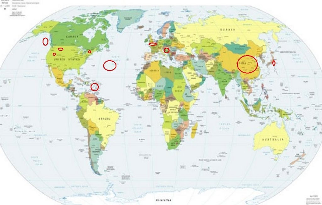
Places to watch.
Good luck to all.
For Friday, 10 November 2006.
--------------------------------------
Eastcentral China (Non-specific - Strong)
--------------------------------------
(Nothing found)
Central Mid-Atlantic
--------------------------------------
2006-11-14 22:31:14 4.7 15.86N 32.52W 20 North Atlantic Ocean
(4 extra days)
Utah
--------------------------------------
06/11/10 01:19:29 39.67N 110.47W 3.4 1.0 9.2 mi NNW of E. Carbon City
06/11/10 07:31:42 39.67N 110.48W 2.1 1.2 9.4 mi NW of E. Carbon City
06/11/10 19:43:14 39.42N 111.22W 0.4 1.5 15.2 mi WNW of Huntington
06/11/10 20:01:51 41.81N 112.31W 7.4 1.0 8.9 mi WNW of Garland
06/11/10 21:15:24 39.41N 111.23W 5.8 1.8 15.2 mi E of Spring City
New York, U.S.(44.17N 74.83W)/Quebec
--------------------------------------
3.1 2006/11/10 17:51:37 46.170N 76.846W 7.0 206 km (128 mi) NNW of Heuvelton, NY
CZECH AND SLOVAK REPUBLICS
(50.48 N 13.53 E) (Strong)
--------------------------------------
2006-11-10 05:45:27.4 45.45N 15.85E 10 ML2.0 CROATIA
ENGLISH CHANNEL (49.601 -0.604)
(Strong)
--------------------------------------
OEYGARDEN FAULT ZONE
Origin time Lat Lon Azres Timres Wres Nphase Ntot Nsta Netmag
2006-313:12.42.23.0 59.76 4.83 11.82 2.87 5.83 3 3 1 1.32
Puerto Rico/Virgin Islands
--------------------------------------
3.3 2006/11/10 07:20:50 18.977N -65.113W 25.1 72 km (45 mi) NNW of Charlotte Amalie, Saint Thomas, US Virgin Islands
2.8 2006/11/10 05:18:16 18.890N -65.112W 43.2 63 km (39 mi) NNW of Charlotte Amalie, Saint Thomas, US Virgin Islands
3.5 2006/11/10 05:14:48 19.110N -65.336W 20.9 89 km (56 mi) N of Culebra, PR
2.8 2006/11/10 05:02:15 18.933N -65.122W 25.4 68 km (42 mi) NNW of Charlotte Amalie, Saint Thomas, US Virgin Islands
2.4 2006/11/10 05:01:18 18.884N -65.133W 25.9 63 km (39 mi) NNW of Charlotte Amalie, Saint Thomas, US Virgin Islands
2.0 2006/11/10 03:57:32 18.988N -65.107W 28.6 73 km (45 mi) NNW of Charlotte Amalie, Saint Thomas, US Virgin Islands
2.9 2006/11/10 03:49:00 18.998N -65.125W 23.9 75 km (46 mi) NNW of Charlotte Amalie, Saint Thomas, US Virgin Islands
3.3 2006/11/10 03:20:06 19.018N -65.095W 17.8 76 km (47 mi) NNW of Charlotte Amalie, Saint Thomas, US Virgin Islands
3.4 2006/11/10 03:10:38 18.980N -65.107W 21.3 72 km (45 mi) NNW of Charlotte Amalie, Saint Thomas, US Virgin Islands
2.3 2006/11/10 02:49:06 18.792N -67.331W 12.6 41 km (26 mi) NW of San Antonio, PR
2.9 2006/11/10 00:21:13 18.162N -66.879W 15.6 11 km ( 7 mi) E of Maricao, PR
Honshu, Japan area
--------------------------------------
4.3 2006/11/11 09:57:03 22.061 142.873 335.9 VOLCANO ISLANDS, JAPAN REGION
Montana (Strong)
--------------------------------------
1.0 2006/11/10 15:08:40 44.538 -110.361 2.6 61 km(38 mi)ESE of West Yellowstone, MT
Gulf of Alaska
--------------------------------------
(Nothing found)
Peace to all.

posted by Unknown @ 5:35 PM
0 comments
![]()
![]()
