*For Thursday, 23 November 2006.
LEGEND for OVERVIEW: Size = My surety of area for quake.
Red Circle = Probable quake to STRONG quake.
Triangle = Very Strong/Stronger quake (Usually takes extra days).
Blue Circle, etc. = Uncertainty of symptom area for probable quake.

Places to watch.
Good luck to all.
For Thursday, 23 November 2006.
--------------------------------------
The Parkfield Fault/Central
--------------------------------------
1.8 2006/11/23 08:00:37 36.584 -121.186 6.6 7 km ( 4 mi) NNW of Pinnacles, CA
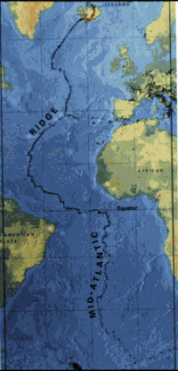
Central Mid Atlantic Ridge (2.38N 32.26W)
(Very Strong)
http://www.answers.com/topic/mid-atlantic-ridge
--------------------------------------
22Nov2006 17:12:12.3 1.0S 24.3W 33 mb=5.1 M*GSR CENTRAL MID-ATLANTIC RIDGE
Mt. Hood and other areas of Washington
State (Strong for Mt. Hood)
--------------------------------------
1.0 2006/11/23 20:43:44 46.851N 121.595W 7.2 32 km (20 mi) S of Greenwater, WA
1.6 2006/11/23 18:26:24 46.195N 122.193W 0.0 1 km ( 1 mi) WSW of Mount St. Helens Volcano, WA
1.8 2006/11/23 17:53:53 46.859N 121.591W 4.3 32 km (20 mi) S of Greenwater, WA
1.8 2006/11/23 10:53:32 46.195N 122.187W 0.0 1 km ( 0 mi) SW of Mount St. Helens Volcano, WA
2.4 2006/11/23 05:46:35 46.200N 122.193W 1.6 1 km ( 1 mi) W of Mount St. Helens Volcano, WA
1.7 2006/11/23 00:37:02 46.196N 122.186W 0.1 1 km ( 0 mi) SW of Mount St. Helens Volcano, WA
1.1 2006/11/24 07:51:34 47.533N 122.670W 22.9 2 km ( 1 mi) S of Navy Yard City, WA
1.1 2006/11/24 02:21:30 47.639N 120.330W 0.5 10 km ( 6 mi) WSW of Entiat, WA
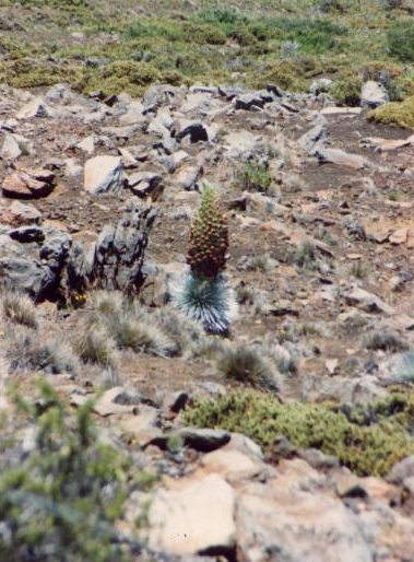
Hawaii and South of (Second day of
symptoms - Very Strong)
http://cruises.about.com/library/pictures/maui/blmaui16.htm
Silversword Plant that grows in lava
--------------------------------------
2.0 2006/11/23 04:44:30 19.363 -155.188 2.9 11 km ( 7 mi) SSE of Volcano, HI
2.0 2006/11/23 07:34:19 20.166 -156.011 16.9 20 km ( 13 mi) WSW of Hawi, HI
2.2 2006/11/23 18:28:48 19.781 -156.092 10.3 11 km ( 7 mi) NW of Kalaoa, HI
5.0 2006/11/23 19:20:10 19.890 -155.979 37.7 13 km ( 8 mi) WSW of Puako, HI
2.4 2006/11/23 19:29:08 20.111 -155.346 6.6 8 km ( 5 mi) NNE of Paauilo, HI
2.0 2006/11/23 21:32:53 19.857 -156.034 12.1 15 km ( 9 mi) NNW of Kalaoa, HI
CHARLOTTE AMALIE, US Virgin Islands
area (18.655 -65.149) (Volcanic - Strong)
--------------------------------------
3.0 2006/11/23 23:17:29 19.595N -67.846W 41.2 141 km (88 mi) NE of Higüey, La Altagracia, Dominican Republic
3.5 2006/11/23 07:17:25 19.160N -64.566W 57.8 54 km (34 mi) NNW of Settlement, Anegada, British Virgin Islands
OFF THE COAST OF COQUIMBO, CHILE
(-30.912 -72.015) (Very Strong)
http://www.ifm-geomar.de/index.php?id=2344&L=1#top

--------------------------------------
4.3 2006/11/27 07:37:28 -22.028 -68.307 104.6 ANTOFAGASTA, CHILE
4.3 2006/11/27 09:49:41 -21.978 -68.367 122.3 ANTOFAGASTA, CHILE
(4 extra days)
The New Madrid Fault (Medium)
--------------------------------------
3.8 2006/11/23 04:42:59 37.171N 81.889W 1.0 11 km ( 7 mi) NW of Richlands, VA?
1.5 2006/11/24 17:47:10 36.510N 89.530W 5.0 9 km ( 5 mi) S of New Madrid, MO
(This particular symptom is non-specific and I think it means for whole area near me here in Ohio.)
Montana/Wyoming/Utah (Non-specific
wandering pain)
--------------------------------------
06/11/23 00:29:56 39.67N 110.49W 2.2 1.3 9.5 mi NW of E. Carbon City
06/11/23 10:03:24 39.53N 111.87W 11.1 1.2 2.3 mi S of Levan
06/11/23 15:36:55 39.68N 110.48W 0.7 1.8 9.8 mi NNW of E. Carbon City
06/11/23 05:14:48 44.04N 110.83W 5.1 1.7 25.8 mi NNE of Driggs
06/11/23 11:23:22 44.56N 110.70W 4.2 1.5 9.7 mi NNE of Old Faithful
06/11/24 16:05:31 41.00N 111.65W 11.6 2.1 3.0 mi SE of Morgan
06/11/24 16:07:30 41.00N 111.65W 11.0 1.9 3.0 mi SE of Morgan
Northern Mid Atlantic Ridge (44.88N 23.69W)
--------------------------------------
(Nothing found)
France (46.37N 0.78E) (MEDIUM)
--------------------------------------
2006-11-22 15:54:32.5 45.81N 6.83E 8 ML3.3 FRANCE
2006-11-22 13:55:45.3 43.04N 0.02E 2 ML3.1 FRANCE
2006-11-22 12:37:12.5 45.83N 5.28E 10 ML2.4 FRANCE
2006-11-22 10:51:07.2 43.93N 8.62W 40 ML3.8 SPAIN
2006-11-23 07:15:49.0 42.07N 7.93W 20 ML2.1 SPAIN
XINJIANG, CHINA area (38.47N 80.57E)
(MEDIUM)
--------------------------------------
5.4 2006/11/23 11:04:45 44.239 83.485 22.2 NORTHERN XINJIANG, CHINA
WEST OF GIBRALTAR (36.57N 9.45W)
(Medium)
--------------------------------------
2006-11-22 04:39:28.2 36.49N 9.51W 30f ML2.8 WEST OF GIBRALTAR
San Simeon, California (35.654 -121.072)
(Medium)
--------------------------------------
(Nothing found)
Central Italy area
--------------------------------------
2006-11-23 22:23:53.0 38.66N 13.03E 21 ML2.9 SICILY, ITALY
2006-11-23 13:33:36 4.2ML 43.16N 13.47E 10 Central Italy
Turkey
--------------------------------------
2006-11-22 14:10:49.9 38.83N 41.62E 28 MD2.8 EASTERN TURKEY
2006-11-22 10:29:56.8 39.94N 40.27E 27 MD2.7 EASTERN TURKEY
2006-11-22 09:54:37.5 37.02N 28.09E 29 MD2.6 WESTERN TURKEY
2006-11-22 09:21:45.1 39.91N 40.24E 17 MD2.7 EASTERN TURKEY
2006-11-22 09:18:59.4 39.88N 40.26E 12 MD2.9 EASTERN TURKEY
2006-11-22 09:16:27.2 39.83N 39.92E 28 MD2.7 EASTERN TURKEY
2006-11-22 09:12:34.2 39.88N 40.29E 30 MD3.3 EASTERN TURKEY
2006-11-22 09:09:31.3 39.86N 40.27E 17 MD2.8 EASTERN TURKEY
2006-11-22 09:06:26.8 39.80N 40.29E 22 MD2.7 EASTERN TURKEY
2006-11-22 01:30:10.9 40.81N 27.75E 20 MD3.1 WESTERN TURKEY
2006-11-23 04:37:35.2 39.91N 42.72E 5 mb4.6 EASTERN TURKEY
Norway Basin area (Strong)
--------------------------------------
TELEMARK-BUSKERUD NORWAY
Origin time Lat Lon Azres Timres Wres Nphase Ntot Nsta Netmag
2006-327:00.12.41.0 60.66 8.56 8.36 0.47 2.56 3 6 2 3.41
FOX ISLANDS, ALEUTIAN ISLANDS, ALASKA
(52.790 -166.813)
--------------------------------------
3.8 2006/11/23 15:52:40 50.028 176.952 100.0 RAT ISLANDS, ALEUTIAN ISLANDS, ALASKA
(More West than expected)
Peace to all.

posted by Unknown @ 3:35 PM
0 comments
![]()
![]()
