*For Monday, 31 July 2006.
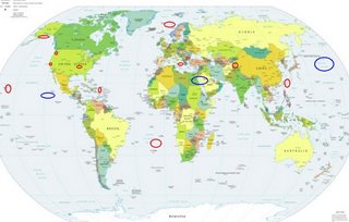
LEGEND for OVERVIEW: Size = My surety of area for quake.
Red Circle = Probable quake to STRONG quake.
Triangle = Very Strong/Stronger quake (Usually takes extra days).
Blue Circle, etc. = Uncertainty of symptom area for probable quake.

Places to watch.
Good luck to all.
For Monday, 31 July 2006.
----------------------------------------
Alaska Peninsula (Indication of depth - Strong)
----------------------------------------
3.3 2006/07/31 12:40:31 54.758 -161.777 50.0 ALASKA PENINSULA
Possibly Pacific Ocean (42.11N 159.44W)
or
Near Guererro, Mexico (16.099 -98.648)
(Unproven symptom)
----------------------------------------
4.3 2006/07/31 12:32:17 17.021 -101.889 35.0 OFFSHORE GUERRERO, MEXICO
5.2 2006/07/31 18:25:15 18.594 -103.851 10.0 OFFSHORE COLIMA, MEXICO
4.4 2006/07/31 17:54:44 18.069 -104.447 10.0 OFFSHORE COLIMA, MEXICO
(Possibly the right quakes, I will watch for a repeat.)
TAIWAN REGION (12:56:50 22.669)
----------------------------------------
28Jul2006 07:40:10.6 24.1N 122.5E 21 M =6.1 M*NEI TAIWAN REGION
(3 days early??? Only 1 day warning??)
EASTERN LOFOTEN BASIN (70.00 12.07)
----------------------------------------
LOFOTEN MARGIN
Origin time Lat Lon Azres Timres Wres Nphase Ntot Nsta Netmag
2006-211:07.23.50.0 68.80 13.18 5.24 0.53 1.84 3 12 1 2.08
WESTERN LOFOTEN BASIN
Origin time Lat Lon Azres Timres Wres Nphase Ntot Nsta Netmag
2006-212:13.48.48.0 69.88 5.45 8.39 3.49 5.58 3 5 2 2.28
Tierras Nuevas Poniente, PR
(19.112N -66.463W) (Medium)
----------------------------------------
2.6 2006/07/31 01:05:53 18.932 -65.179 27.2 70 km ( 43 mi) NNW of CHARLOTTE AMALIE, US Virgin Islands
3.0 2006/07/31 01:04:13 18.861 -65.222 4.4 62 km ( 39 mi) N of Culebra, PR
3.1 2006/07/31 01:45:40 18.874 -65.209 7.6 64 km ( 40 mi) N of Culebra, PR
2.5 2006/07/31 07:59:31 17.668 -64.946 23.5 8 km ( 5 mi) SW of Frederiksted Southeast, US Virgin Islands
3.3 2006/07/31 16:14:51 18.978 -68.167 35.8 70 km ( 43 mi) NE of Higüey, Dominican Republic
Sicily, Italy/Ionian Sea
----------------------------------------
(Nothing found)
Mt. St. Helen’s
----------------------------------------
1.7 2006/07/31 20:48:44 46.197N 122.187W 0.0 1 km ( 0 mi) WSW of Mount St. Helens Volcano, WA
1.5 2006/07/31 17:47:14 46.194N 122.198W 0.0 2 km ( 1 mi) WSW of Mount St. Helens Volcano, WA
1.5 2006/07/31 13:01:47 46.196N 122.196W 1.0 1 km ( 1 mi) WSW of Mount St. Helens Volcano, WA
3.5 2006/07/31 09:44:25 46.196N 122.190W 0.9 1 km ( 1 mi) WSW of Mount St. Helens Volcano, WA
1.2 2006/07/31 05:44:46 46.196N 122.196W 0.8 1 km ( 1 mi) WSW of Mount St. Helens Volcano, WA
3.6 2006/07/31 02:33:59 46.195N 122.192W 0.7 1 km ( 1 mi) WSW of Mount St. Helens Volcano, WA
1.9 2006/07/31 00:12:44 46.197N 122.194W 0.7 1 km ( 1 mi) WSW of Mount St. Helens Volcano, WA
San Simeon (35.654 -121.072)
----------------------------------------
(Nothing found)
Hawaii
----------------------------------------
2.3 2006/07/31 20:37:27 19.987 -155.398 23.1 7 km ( 4 mi) SSW of Paauilo, HI
2.0 2006/07/31 20:36:46 19.385 -155.282 2.9 9 km ( 5 mi) SW of Volcano, HI
2.1 2006/07/31 22:44:06 19.323 -155.502 7.3 13 km ( 8 mi) N of Pahala, HI
Possibly Egypt or Red Sea area
(New symptom - Strong)
----------------------------------------
2006-08-05 19:01:21.5 12.27N 44.63E 3 ML3.5 WESTERN ARABIAN PENINSULA
2006-08-05 17:56:48.0 12.23N 44.54E 4 ML3.3 WESTERN ARABIAN PENINSULA
(5 extra days)
South Atlantic Ocean (25.84S 2.48W)
(STRONG)
----------------------------------------
01Aug2006 12:01:52.0 7.0S 12.9W100 mb=4.6 M*GSR ASCENSION ISLAND REGION
(Not so far south as expected, etc.)
Islamabad, Pakistan area
----------------------------------------
4.2 2006/07/30 02:47:19 36.676 71.638 171.1 HINDU KUSH REGION, AFGHANISTAN
The New Madrid Fault
----------------------------------------
1.3 2006/08/01 08:58:00 36.260N 89.500W 7.1 1 km ( 1 mi) WSW of Ridgely, TN
Peace to all.

