*For Wednesday, 29 November 2006.
LEGEND for OVERVIEW: Size = My surety of area for quake.
Red Circle = Probable quake to STRONG quake.
Triangle = Very Strong/Stronger quake (Usually takes extra days).
Blue Circle, etc. = Uncertainty of symptom area for probable quake.
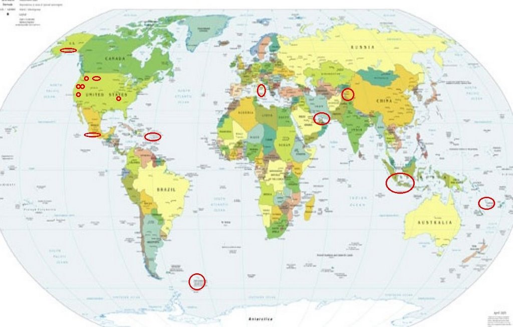
Places to watch.
Good luck to all.
For Wednesday, 29 November 2006.
--------------------------------------
Mammoth Lakes/Tom’s Place
--------------------------------------
1.7 2006/11/26 03:18:44 37.533 -118.826 8.3 13 km ( 8 mi) WSW of Toms Place, CA
1.2 2006/11/26 05:20:01 37.629 -119.032 5.1 5 km ( 3 mi) W of Mammoth Lakes, CA
1.5 2006/11/26 23:51:59 37.456 -118.840 7.3 18 km ( 11 mi) SW of Toms Place, CA
1.3 2006/11/26 23:03:05 37.456 -118.843 7.0 19 km ( 12 mi) SW of Toms Place, CA
1.5 2006/11/26 22:51:17 37.453 -118.842 7.8 19 km ( 12 mi) SW of Toms Place, CA
1.8 2006/11/26 22:36:58 37.457 -118.835 6.8 18 km ( 11 mi) SW of Toms Place, CA
1.3 2006/11/26 22:22:43 37.464 -118.838 7.9 18 km ( 11 mi) SW of Toms Place, CA
1.7 2006/11/26 22:22:16 37.461 -118.844 0.0 18 km ( 11 mi) SW of Toms Place, CA
2.2 2006/11/26 22:21:32 37.444 -118.842 6.4 19 km ( 12 mi) SW of Toms Place, CA
2.6 2006/11/26 22:21:27 37.450 -118.844 8.1 19 km ( 12 mi) SW of Toms Place, CA
1.9 2006/11/26 22:18:11 37.455 -118.840 8.2 18 km ( 11 mi) SW of Toms Place, CA
1.6 2006/11/26 22:16:08 37.451 -118.839 5.8 19 km ( 12 mi) SW of Toms Place, CA
1.1 2006/11/26 22:15:46 37.446 -118.827 8.1 18 km ( 11 mi) SW of Toms Place, CA
4.3 2006/11/26 22:11:48 37.453 -118.841 9.3 19 km ( 12 mi) SW of Toms Place, CA
(3 days early - must have been one of the missed symptoms during holiday)
1.0 2006/11/27 14:15:26 37.462 -118.658 1.8 7 km ( 5 mi) NW of Round Valley, CA
2.4 2006/11/27 13:47:59 37.404 -118.055 3.9 7 km ( 5 mi) WNW of Deep Springs, CA
1.5 2006/11/27 05:06:28 37.455 -118.837 7.3 18 km ( 11 mi) SW of Toms Place, CA
1.3 2006/11/27 00:51:59 37.451 -118.838 5.8 19 km ( 12 mi) SW of Toms Place, CA
2.1 2006/11/27 00:46:52 37.452 -118.843 7.8 19 km ( 12 mi) SW of Toms Place, CA
(2 days early)
1.5 2006/11/28 23:50:13 37.606 -118.471 9.2 19 km ( 12 mi) ENE of Toms Place, CA
1.7 2006/11/28 17:17:01 37.459 -118.839 7.3 18 km ( 11 mi) SW of Toms Place, CA
1.3 2006/11/28 13:50:47 37.456 -118.838 6.3 18 km ( 11 mi) SW of Toms Place, CA
1.9 2006/11/28 13:37:54 37.462 -118.839 8.2 18 km ( 11 mi) SW of Toms Place, CA
1.3 2006/11/28 08:44:40 37.535 -118.825 7.6 13 km ( 8 mi) WSW of Toms Place, CA
1.5 2006/11/28 07:12:07 37.450 -118.841 6.4 19 km ( 12 mi) SW of Toms Place, CA
1.2 2006/11/28 01:31:42 37.625 -118.867 4.8 10 km ( 6 mi) E of Mammoth Lakes, CA
1.6 2006/11/28 00:09:53 37.480 -118.791 7.1 13 km ( 8 mi) SW of Toms Place, CA
1.3 2006/11/29 17:01:22 37.569 -118.867 8.8 12 km ( 8 mi) SE of Mammoth Lakes, CA
1.1 2006/11/29 15:37:07 37.541 -118.829 6.2 13 km ( 8 mi) W of Toms Place, CA
1.8 2006/11/29 10:41:02 37.462 -118.844 8.4 18 km ( 11 mi) SW of Toms Place, CA
1.5 2006/11/29 05:30:58 37.474 -118.843 2.2 17 km ( 11 mi) SW of Toms Place, CA
2.4 2006/11/29 02:24:45 37.478 -118.839 4.1 17 km ( 10 mi) WSW of Toms Place, CA
1.1 2006/11/29 00:30:25 37.456 -118.840 7.3 18 km ( 11 mi) SW of Toms Place, CA
1.6 2006/11/29 00:25:29 37.457 -118.841 7.4 18 km ( 11 mi) SW of Toms Place, CA
1.3 2006/11/30 14:18:39 37.429 -118.506 3.3 8 km ( 5 mi) E of Round Valley, CA
1.5 2006/11/30 11:50:38 37.436 -118.501 12.4 9 km ( 6 mi) ENE of Round Valley, CA
2.3 2006/11/30 03:15:13 37.570 -118.868 8.4 12 km ( 8 mi) SE of Mammoth Lakes, CA
South Sandwich Islands area (Second day
symptom - STRONG.)
--------------------------------------
(Nothing found - may still be coming.)
Puerto Rico/Virgin Islands (STRONG)
--------------------------------------
1.6 2006/11/29 15:40:45 18.203N -66.855W 24.3 11 km ( 7 mi) SSE of Lares, PR
3.5 2006/11/29 10:30:51 19.567N -67.727W 39.8 137 km (85 mi) NNW of San Antonio, PR
3.1 2006/11/29 08:02:15 18.534N -68.086W 102.3 66 km (41 mi) E of Higüey, La Altagracia, Dominican Republic
2.9 2006/11/29 04:59:31 19.039N -67.878W 7.7 99 km (62 mi) ENE of Higüey, La Altagracia, Dominican Republic
3.7 2006/11/30 17:09:19 19.944N -65.301W 25.1 170 km (105 mi) NW of Settlement, Anegada, British Virgin Islands
3.8 2006/11/30 06:24:10 19.173N -68.752W 109.0 54 km (34 mi) NE of El Seybo, El Seybo, Dominican Republic
2.6 2006/11/30 01:02:59 17.944N -66.239W 11.3 2 km ( 1 mi) SW of Central Aguirre, PR
2.6 2006/11/30 00:57:30 17.948N -66.243W 13.8 2 km ( 1 mi) WSW of Central Aguirre, PR
3.1 2006/11/30 00:02:17 17.746N -68.511W 73.2 90 km (56 mi) SSE of La Romana, La Romana, Dominican Republic
Indonesia
--------------------------------------
2006-11-29 01:32:19.1 2.54N 128.29E 60 mb6.1 HALMAHERA, INDONESIA
The Geysers and South of(Strong)
--------------------------------------
2.2 2006/11/28 22:59:24 38.780 -122.760 0.2 4 km ( 3 mi) ESE of The Geysers, CA
1.8 2006/11/28 17:09:30 38.831 -122.800 0.2 4 km ( 2 mi) N of The Geysers, CA
1.9 2006/11/28 16:59:47 38.831 -122.800 0.8 4 km ( 2 mi) N of The Geysers, CA
1.5 2006/11/28 12:49:15 38.815 -122.816 1.1 2 km ( 1 mi) NNW of The Geysers, CA
1.4 2006/11/28 01:39:34 38.810 -122.794 2.7 2 km ( 1 mi) NE of The Geysers, CA
2.5 2006/11/29 04:48:14 38.833 -122.801 0.8 4 km ( 2 mi) N of The Geysers, CA
1.4 2006/11/29 08:10:10 38.832 -122.870 0.1 7 km ( 4 mi) NW of The Geysers, CA
Italy (Various areas)
--------------------------------------
(Nothing found)
Lake Tahoe area
--------------------------------------
1.8 2006/11/27 15:45:38 39.231 -120.101 7.6 5 km ( 3 mi) WSW of Tahoe Vista, CA
(2 days early)
Alaska Peninsula
--------------------------------------
(Nothing found)
Chiapas, Mexico
--------------------------------------
4.5 2006/11/29 16:15:12 26.702 -114.093 10.0 143km(89mi) S of Guerrero Negro, Mexico
4.8 2006/11/29 14:34:02 26.621 -114.136 10.0 152km(95mi) S of Guerrero Negro, Mexico
Southern Iran area (May not be an
earthquake symptom - maybe weather.)
--------------------------------------
2006-11-29 06:53:30.0 28.95N 52.67E 8 M3.6 SOUTHERN IRAN
2006-11-29 21:38:51.8 37.60N 57.17E 14 M3.5 NORTHEASTERN IRAN
The New Madrid Fault
--------------------------------------
2.1 2006/11/29 18:49:23 36.620N 89.570W 11.4 5 km ( 3 mi) NW of New Madrid, MO
4.1 2006/11/29 01:22:55 46.482N 81.168W 1.0 217 km (135 mi) ENE of De Tour Village, MI
(Posted on the 26th also because most symptoms were felt then.)
TAJIKISTAN-XINJIANG BORDER REG
(38.57N 73.11E)
--------------------------------------
2006-11-29 10:57:28.0 41.49N 76.52E ML3.3 KYRGYZSTAN
2006-11-29 13:48:58.4 35.03N 73.92E 80 mb4.7 NORTHWESTERN KASHMIR
2006-11-29 15:13:12.0 40.74N 73.35E ML3.7 KYRGYZSTAN
2006-11-29 20:39:15.4 36.52N 70.58E 200 mb4.0 HINDU KUSH REGION, AFGHANISTAN
Vanuatu area(15S 167E) (May also be
weather and not an earthquake.)
--------------------------------------
2006-11-28 04:25:16.0 14.98S 167.08E 300f mb5.0 VANUATU
29Nov2006 08:41:25.6 18.5S 168.0E 33 mb=5.5 M GSR VANUATU ISLANDS
Greenwater, WA area (46.851 -121.595)
--------------------------------------
1.4 2006/11/28 16:54:06 46.445 -121.105 0.0 31 km ( 19 mi) W of White Swan, WA
1.6 2006/11/28 08:30:48 47.593 -121.711 19.0 12 km ( 7 mi) NE of Snoqualmie, WA
1.3 2006/11/29 20:53:43 47.643 -120.434 0.6 14 km ( 9 mi) N of Cashmere, WA
1.6 2006/11/29 09:58:57 47.621 -121.264 10.0 12 km ( 7 mi) SE of Skykomish, WA
Montana
--------------------------------------
2.2 2006/11/28 11:49:22 42.417 -111.505 4.3 13 km ( 8 mi) WSW of Georgetown, ID
1.7 2006/11/28 06:00:47 44.517 -110.786 2.1 30 km(19 mi)ESE of West Yellowstone, MT
2.3 2006/11/28 05:49:15 42.512 -111.504 2.4 12 km ( 7 mi) WNW of Georgetown, ID
1.6 2006/11/28 05:01:18 42.507 -111.504 4.5 12 km ( 7 mi) WNW of Georgetown, ID
1.4 2006/11/28 04:21:42 42.511 -111.508 4.5 12 km ( 8 mi) WNW of Georgetown, ID
2.6 2006/11/29 17:46:00 42.425 -111.501 1.9 12 km ( 8 mi) WSW of Georgetown, ID
1.3 2006/11/29 08:27:07 42.497 -111.490 6.4 10 km ( 6 mi) WNW of Georgetown, ID
1.5 2006/11/30 20:01:39 46.999 -113.624 0.5 22 km ( 14 mi) SSW of Seeley Lake, MT
2.3 2006/11/30 02:52:10 42.420 -111.523 6.6 14 km ( 9 mi) WSW of Georgetown, ID
Peace to all.

posted by Unknown @ 12:39 PM
0 comments
![]()
![]()
