*For Thursday, 18 May 2006.
LEGEND for OVERVIEW: Size = My surety of area for quake.
Red Circle = Probable quake to STRONG quake.
Triangle = Very Strong or Stronger quake (And usually takes extra days).
Blue Circle, etc. = Uncertainty of symptom area for probable quake.
Places to watch.
Good luck to all.
For Thursday, 18 May 2006.
----------------------------------------
Utah/Nevada
----------------------------------------
MAP 1.5 2006/05/18 00:09:53 39.611 -110.398 1.1 7 km ( 4 mi) N of Sunnyside, UT
MAP 1.4 2006/05/18 00:55:04 39.732 -110.740 0.9 11 km ( 7 mi) ENE of Helper, UT
MAP 1.2 2006/05/18 02:30:11 38.079 -116.823 3.6 36 km ( 22 mi) E of Tonopah, NV
MAP 1.6 2006/05/18 03:21:57 39.729 -110.803 0.2 6 km ( 4 mi) NE of Helper, UT
MAP 1.5 2006/05/18 03:25:04 39.730 -110.807 0.1 6 km ( 4 mi) NE of Helper, UT
MAP 1.7 2006/05/18 03:40:33 39.731 -110.810 0.1 6 km ( 4 mi) NE of Helper, UT
MAP 1.3 2006/05/18 04:00:12 39.726 -110.744 1.2 11 km ( 7 mi) ENE of Helper, UT
MAP 1.9 2006/05/18 04:32:11 38.981 -111.320 10.8 9 km ( 6 mi) NW of Emery, UT
MAP 2.0 2006/05/18 20:00:33 39.545 -112.196 2.9 7 km ( 4 mi) ENE of Leamington, UT
Czech and Slovak Republics and North of (50.55N 14.04E) (MEDIUM)
----------------------------------------
2006-05-18 13:58:57.0 49.75 N 18.36 E 2 ML 2.6 CZECH AND SLOVAK REPUBLICS
2006-05-18 22:11:35.8 50.09 N 15.21 E 10 ML 2.2 CZECH AND SLOVAK REPUBLICS
Germany/Poland area
----------------------------------------
2006-05-19 13:48:08.0 49.40 N 6.90 E 10 G ML 2.4 GERMANY
Mt. St. Helen’s
----------------------------------------
MAP 1.6 2006/05/18 03:50:05 46.194 -122.196 0.0 1 km ( 1 mi) WSW of Mount St. Helens Volcano, WA
MAP 1.5 2006/05/18 08:45:38 46.195 -122.195 0.4 1 km ( 1 mi) WSW of Mount St. Helens Volcano, WA
MAP 1.7 2006/05/18 12:21:43 46.196 -122.194 0.6 1 km ( 1 mi) WSW of Mount St. Helens Volcano, WA
MAP 1.3 2006/05/18 15:52:15 46.197 -122.194 0.7 1 km ( 1 mi) WSW of Mount St. Helens Volcano, WA
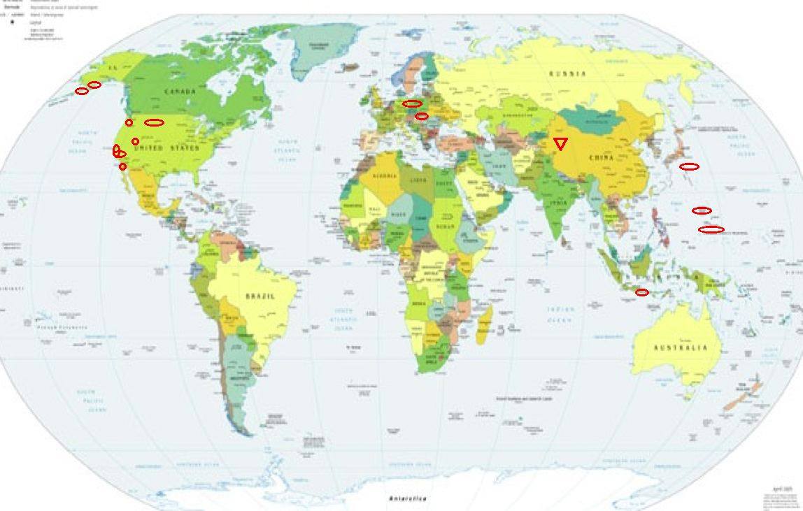
XINJIANG, CHINA area (38.47N 80.57E) (Second day for this symptom but much stronger and coldness [Don’t know what cold means yet.] - Very Strong.)
http://www.thingsasian.com/pod/compose.654.html>thingsasian
----------------------------------------
2006-05-18 16:40:35.0 43.42 N 82.90 E ML 3.0 NORTHERN XINJIANG, CHINA
(These symptoms indicate a lot more coming to this area!)
The Parkfield Fault (I keep feeling it in the center but Parkfield or Pinnacles quakes.)
----------------------------------------
MAP 1.5 2006/05/18 16:35:08 36.013 -120.579 4.0 18 km ( 11 mi) NW of Parkfield, CA
MAP 1.2 2006/05/18 19:22:15 36.012 -120.584 4.6 18 km ( 11 mi) NW of Parkfield, CA
Izu Islands area (31.307 139.870)
----------------------------------------
(Nothing found)
Kenai Peninsula, Alaska area (60.616 -151.859) (Indication of depth - Strong)
----------------------------------------
MAP 2.6 2006/05/18 20:09:36 59.289 -154.142 120.0 SOUTHERN ALASKA
Mariana Islands then closer to Caroline Islands (STRONG for Caroline Islands area.)
----------------------------------------
2006-05-18 06:55:18.7 6.86 S 152.61 E 30 f mb 5.1 NEW BRITAIN
Java, Indonesia area (MEDIUM)
----------------------------------------
2006-05-19 22:19:19.2 8.35 S 106.09 E 10 mb 5.2 SOUTH OF JAWA, INDONESIA
2006-05-20 18:42:48.2 11.19 S 117.13 E 80 mb 4.9 SOUTH OF SUMBAWA, INDONESIA
(2 extra days)
Coso Junction
----------------------------------------
MAP 1.5 2006/05/17 22:45:11 36.111 -117.861 3.7 11 km ( 7 mi) NE of Coso Junction, CA
MAP 1.3 2006/05/19 20:46:30 35.960 -117.673 3.6 26 km ( 16 mi) ESE of Coso Junction, CA
MAP 2.1 2006/05/20 12:42:32 36.017 -117.773 4.1 16 km ( 10 mi) E of Coso Junction, CA
MAP 2.4 2006/05/20 15:38:23 36.062 -117.715 2.7 21 km ( 13 mi) E of Coso Junction, CA
(2 extra days)
Guadalupe Victoria, Mexico (Indication of depth - Strong)
----------------------------------------
MAP 1.8 2006/05/17 21:21:15 32.578 -116.791 0.0 15 km ( 9 mi) W of Tecate, Mexico
MAP 2.2 2006/05/17 22:13:14 32.194 -115.817 6.0 60 km ( 38 mi) SSW of Mexicali, Mexico
Montana/Idaho/Wyoming
----------------------------------------
MAP 1.5 2006/05/18 05:07:56 48.108 -115.147 0.7 43 km ( 27 mi) SE of Libby, MT
MAP 1.1 2006/05/18 07:00:22 45.902 -111.154 5.6 14 km ( 9 mi) N of Belgrade, MT
MAP 1.0 2006/05/18 07:25:50 46.767 -112.600 3.0 19 km ( 12 mi) N of Avon, MT
MAP 3.9 2006/05/18 10:16:21 44.173 -110.337 0.2 70 km ( 44 mi) NE of Alta, WY
MAP 2.2 2006/05/18 11:09:40 44.565 -110.921 10.8 18 km ( 11 mi) SE of West Yellowstone, MT
MAP 1.5 2006/05/18 23:48:14 44.788 -110.977 7.1 17 km ( 11 mi) NE of West Yellowstone, MT
MAP 1.4 2006/05/18 23:37:29 44.791 -110.978 6.2 17 km ( 11 mi) NE of West Yellowstone, MT
MAP 1.7 2006/05/18 23:02:58 44.791 -110.977 6.7 18 km ( 11 mi) NE of West Yellowstone, MT
MAP 2.9 2006/05/18 23:02:18 44.792 -110.981 7.4 17 km ( 11 mi) NE of West Yellowstone, MT
MAP 1.8 2006/05/18 22:34:36 44.791 -110.976 7.2 18 km ( 11 mi) NE of West Yellowstone, MT
MAP 1.4 2006/05/19 01:56:08 45.336 -112.558 5.3 15 km ( 9 mi) NNE of Dillon, MT
Aleutian Islands (Probably very close to the deep quake at Kenai Peninsula)
----------------------------------------
MAP 3.0 2006/05/18 02:32:08 51.934 -166.560 50.0 SOUTH OF THE ALEUTIAN ISLANDS
MAP 4.0 2006/05/18 01:39:15 51.733 -171.072 1.0 FOX ISLANDS, ALEUTIAN ISLANDS, ALASKA
Peace to all.

posted by Unknown @ 2:59 PM
0 comments
![]()
![]()
