*For Tuesday, 4 July 2006.
LEGEND for OVERVIEW: Size = My surety of area for quake.
Red Circle = Probable quake to STRONG quake.
Triangle = Very Strong/Stronger quake (Usually takes extra days).
Blue Circle, etc. = Uncertainty of symptom area for probable quake.
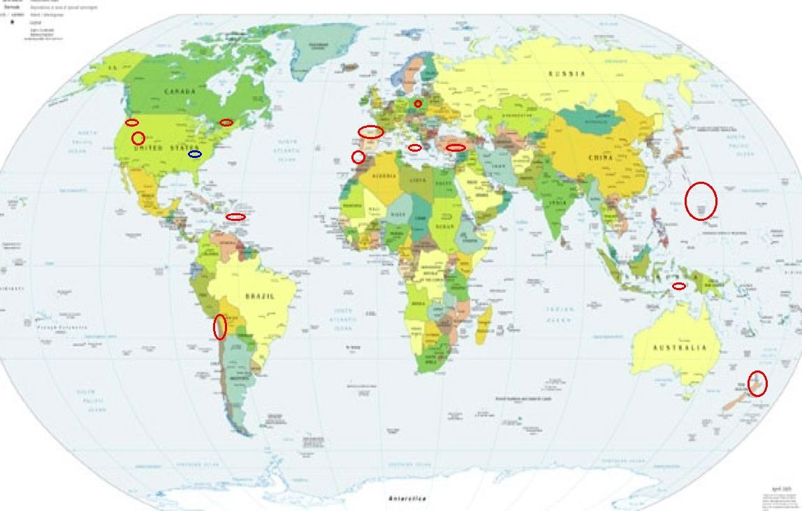
Places to watch.
Good luck to all.
For Tuesday, 4 July 2006.
----------------------------------------
Portugal/Spain area
----------------------------------------
2006-07-04 03:07:30.3 28.02N 16.26W 17 mb2.6 CANARY ISLANDS, SPAIN REG
(More South than expected.)
Poland
----------------------------------------
2006-07-03 03:31:58.2 51.00N 15.95E 10 ML2.5 POLAND
2006-07-03 15:56:43.3 51.35N 16.14E ML2.3 POLAND
2006-07-04 16:09:01.3 51.50N 16.11E 10 ML3.7 POLAND
2006-07-04 16:26:36.6 51.33N 16.18E 10 ML2.3 POLAND
2006-07-04 19:07:05.3 51.47N 16.14E 2 ML2.1 POLAND
2006-07-05 03:17:34.8 51.32N 16.22E 10 ML2.2 POLAND
(2 extra days)
Possibly Williamsburg, KY area (36.810N 84.030W)
(Unproven symptom and if right, it took
10 extra days last time.)
----------------------------------------
1.5 2006/07/04 03:10:38 36.270 -89.460 7.0 2 km ( 1 mi) ENE of Ridgely, TN
1.5 2006/07/05 00:51:54 36.270 -89.460 5.4 2 km ( 1 mi) ENE of Ridgely, TN
1.5 2006/07/05 00:28:19 36.270 -89.460 6.2 2 km ( 1 mi) ENE of Ridgely, TN
1.8 2006/07/05 03:59:17 36.260 -89.470 6.6 1 km ( 1 mi) ESE of Ridgely, TN
Little Harbour, British Virgin Islands
area (18.923 -64.846)
----------------------------------------
2006/07/04 22:33:13.89 17.983N 66.938W 8.8 2.0 C South Puerto Rico
2006/07/05 03:02:55.30 18.135N 64.925W 17.2 3.0 B Virgin Island Platform
Sicily, Italy/Ionian Sea
----------------------------------------
2006-07-04 21:25:45.0 39.60N 13.40E 10 ML2.8 TYRRHENIAN SEA
2006-07-04 21:56:18.0 38.66N 16.29E 8 ML2.5 SOUTHERN ITALY
Utah/Nevada
----------------------------------------
2.0 2006/07/04 01:00:51 37.464 -117.138 0.0 21 km ( 13 mi) NNE of Tokop, NV
1.7 2006/07/04 11:29:07 38.021 -118.661 10.6 34 km ( 21 mi) SSW of Qualeys Camp, NV
06/07/04 05:19:16 38.83N 111.50W 6.6 1.9 15.0 mi SW of Emery
06/07/04 10:14:06 39.67N 110.52W 2.3 1.3 10.1 mi NW of E. Carbon City
06/07/04 11:02:52 41.97N 112.46W 2.5 0.5 18.9 mi SSW of Malad City
06/07/04 22:58:35 39.66N 110.52W 3.9 1.1 9.7 mi NW of E. Carbon City
CHARLEVOIX SEISMIC ZONE, QUE.
(47.75N 69.73W)
----------------------------------------
2006/07/04 22:38:16 47.50N 70.04W 12.7 1.7MN CHARLEVOIX SEISMIC ZONE,QUE.
Strait of Gibraltar area (STRONG)
----------------------------------------
2006-07-05 00:33:26.7 36.48N 11.28W 27 mb3.7 NORTH ATLANTIC OCEAN
Timor area (8.54S 125.80E)
(Third day symptom - STRONG.)
----------------------------------------
2006-07-04 18:37:03 4.8 6.46S 130.35E Banda Sea
Mt. St. Helen’s and surrounding area
(STRONG)
----------------------------------------
1.2 2006/07/04 19:39:01 46.196N 122.196W 0.6 1 km(1 mi) WSW of Mount St. Helens Volcano, WA
2.7 2006/07/04 17:21:22 42.086N 120.252W 1.6 14 km(9 mi) SE of Lakeview, OR
2.7 2006/07/04 15:32:29 46.197N 122.198W 0.0 1 km(1 mi) WSW of Mount St. Helens Volcano, WA
1.3 2006/07/04 14:32:11 46.195N 122.196W 0.0 1 km(1 mi) WSW of Mount St. Helens Volcano, WA
3.6 2006/07/04 13:37:02 48.355N 123.195W 45.7 15 km(10 mi) ESE of Victoria, British Columbia, Canada
1.6 2006/07/04 08:47:28 46.196N 122.195W 0.6 1 km(1 mi) WSW of Mount St. Helens Volcano, WA
1.7 2006/07/04 05:55:39 42.105N 120.251W 9.0 12 km(8 mi) SE of Lakeview, OR
1.5 2006/07/04 04:30:46 47.745N 120.294W 0.7 10 km(6 mi) NW of Entiat, WA
Mariana Islands (Medium)
----------------------------------------
05Jul2006 07:13:12.9 14.7N 144.3E 33 MS=4.2 M GSR MARIANA ISLANDS
TARAPACA, CHILE (19.23S 69.13W)
----------------------------------------
(Came in on the 5th and posted there.)
NORTH ISLAND OF NEW ZEALAND
(-39.900 176.830)
----------------------------------------
Reference number: 2590398/G
Universal Time: 2 July 2006 at 07:28
NZ Standard Time: Sunday, 2 July 2006 at 7:28 pm
Latitude, Longitude: 37.21°S, 177.35°E
Location: 40 km north-east of White Island
Focal depth: 160 km
Richter magnitude: 5.7
(2 days early)
Reference number: 2590804/G
Universal Time: 3 July 2006 at 01:44
NZ Standard Time: Monday, 3 July 2006 at 1:44 pm
Latitude, Longitude: 42.67°S, 172.91°E
Location: 20 km south of Hanmer Springs
Focal depth: 50 km
Richter magnitude: 4.5
Reference number: 2591272/G
Universal Time: 4 July 2006 at 00:32
NZ Standard Time: Tuesday, 4 July 2006 at 12:32 pm
Latitude, Longitude: 40.73°S, 175.48°E
Location: 20 km south-west of Eketahuna
Focal depth: 30 km
Richter magnitude: 3.5
Turkey (Medium)
----------------------------------------
2006-07-04 06:38:56.2 37.84N 33.83E 29 ML3.5 TURKEY
2006-07-04 17:16:34.5 36.07N 29.12E 42 MD3.2 TURKEY
Peace to all.

posted by Unknown @ 3:34 PM
0 comments
![]()
![]()
