*For Tuesday, 31 October 2006.
LEGEND for OVERVIEW: Size = My surety of area for quake.
Red Circle = Probable quake to STRONG quake.
Triangle = Very Strong/Stronger quake (Usually takes extra days).
Blue Circle, etc. = Uncertainty of symptom area for probable quake.
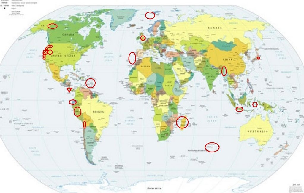
Places to watch.
Good luck to all.
For Tuesday, 31 October 2006.
--------------------------------------
Java, Indonesia area.
--------------------------------------
2006-10-30 01:00:37.8 6.87S 106.98E 94 mb4.7 JAVA, INDONESIA
Puerto Rico/Virgin Islands
(Strong for Virgin Islands)
--------------------------------------
3.4 2006/10/31 23:19:32 18.807N -65.852W 52.3 42 km (26 mi) N of Suárez, PR
3.5 2006/10/31 21:49:02 19.227N -64.752W 25.1 72 km (44 mi) NW of Settlement, Anegada, British Virgin Islands
2.4 2006/10/31 16:06:04 17.741N -65.792W 13.9 31 km (19 mi) SSE of Emajagua, PR
2.3 2006/10/31 09:49:48 18.619N -66.746W 13.6 16 km (10 mi) NNE of Carrizales, PR
Banda Sea area (6.46S 130.35E)
(Second day symptom - STRONG.)
--------------------------------------
(Came in on the 30th and posted there.)
West of Gibraltar (36.57N 9.45W)
(STRONG)
--------------------------------------
2006-11-01 01:01:27.0 37.32N 24.60W 15 ML3.6 AZORES ISLANDS REGION
2006-11-01 04:16:50.0 36.18N 11.65W 31 ML2.3 AZORES-CAPE ST. VINCENT RIDGE
ENGLISH MIDLANDS area (53.38 -0.99)
(Second day but different symptom - Strong)
--------------------------------------
SHETLAND-ORKNEY ISLANDS
Origin time Lat Lon Azres Timres Wres Nphase Ntot Nsta Netmag
2006-304:16.59.31.0 60.57 0.44 5.40 0.15 1.50 2 2 1 2.49
FAROES-HEBRIDES REGION
Origin time Lat Lon Azres Timres Wres Nphase Ntot Nsta Netmag
2006-304:18.47.31.0 58.16 -8.78 20.15 0.23 5.27 2 2 1 1.52
Fall River Mills, California area
(40.946°N 121.531°W)
--------------------------------------
1.9 2006/10/31 05:16:51 40.526 -124.073 18.9 3 km ( 2 mi) SSE of Hydesville, CA
2.2 2006/10/31 05:31:29 40.509 -123.508 4.1 31 km ( 19 mi) WSW of Hayfork, CA
2.0 2006/10/31 07:54:16 40.522 -124.063 18.5 4 km ( 2 mi) SE of Hydesville, CA
1.8 2006/10/31 09:19:38 40.553 -124.088 14.8 0 km ( 0 mi) N of Hydesville, CA
2.8 2006/10/31 12:30:15 40.521 -124.061 17.6 4 km ( 2 mi) SE of Hydesville, CA
2.6 2006/10/31 12:56:14 40.512 -124.064 18.7 4 km ( 2 mi) ENE of Rio Dell, CA
2.0 2006/10/31 13:24:00 40.550 -124.087 18.9 0 km ( 0 mi) NE of Hydesville, CA
Costa Rica (Volcanic - possibly Arenal
Volcano - Very Strong.)
arenal.net

--------------------------------------
06/10/31 23:23:56 13.20N 87.62W 15.0 3.0ML Golfo de Fonseca
06/10/31 22:09:28 11.08N 82.31W 15.0 3.7ML Sismo regional o lejano
06/10/31 09:48:20 13.17N 87.45W 1.0 2.6ML Honduras
06/10/31 08:32:01 10.46N 86.78W 31.2 3.2ML Oceano Pacífico de Nicaragua
06/10/31 04:48:58 12.99N 87.72W 1.0 3.0MC Golfo de Fonseca
06/10/31 03:47:07 11.18N 86.43W 5.6 3.4MC Frente a El Astillero
06/10/31 03:12:45 11.49N 86.87W 5.0 3.0MC Frente a Masachapa
06/11/01 21:14:51 11.59N 87.21W 28.5 2.9ML Frente a Puerto Sandino
06/11/01 11:38:32 13.17N 89.32W 1.0 4.5ML Frente a El Salvador
06/11/01 00:59:20 11.82N 87.42W 1.0 2.5ML Frente a Poneloya
06/11/02 23:11:41 11.35N 87.75W 80.8 3.2ML Frente a Poneloya
06/11/02 17:54:56 18.10N 91.58W 5.1 5.1ML Sismo regional o lejano
06/11/02 16:22:24 12.54N 88.22W 5.0 3.0ML Frente al Golfo de Fonseca
06/11/02 16:08:45 11.58N 86.50W 76.3 2.5ML Frente a La Boquita y Casares
06/11/02 09:40:25 12.22N 87.73W 6.2 3.1ML Frente al Cosigüina
06/11/02 03:56:03 13.01N 87.63W 1.0 3.0ML Cerca del volcan Cosigüina
06/11/02 02:02:56 13.01N 87.57W 1.0 3.1MC Cerca del volcan Cosigüina
(2 extra days for Volcano Cosigüina not Arenas.)
http://www.vianica.com/activity/52/hiking-the-cosiguina-volcano
WESTERN LOFOTEN BASIN area (70.03 3.17)
(Very interesting symptom - thin left ear tone
ending with a “ping”. Don’t know what to
make of it.)
--------------------------------------
2006-11-02 22:53:09.2 70.79N 6.54E 119 mb4.8 NORWEGIAN SEA
2006-11-02 22:47:39.1 69.74N 2.71E 40 mb4.6 NORWEGIAN SEA
CENTRAL PERU (14.24S 72.76W)
--------------------------------------
2006-10-30 04:15:48.8 15.22S 70.58W 100 mb5.1 SOUTHERN PERU
McDonald Island area (53 06S 72 31E)
(Possibly volcanic - Strong.)
--------------------------------------
(Nothing found)
Hollister, CA area (36.794 -121.407)
(Another odd symptom for this area.)
--------------------------------------
2.2 2006/10/31 13:10:29 36.672 -121.293 3.1 13 km ( 8 mi) S of Tres Pinos, CA
Portland, OR area (45.639N 122.719W)
--------------------------------------
(Nothing found)
Greenwater, WA area (46.851 -121.601)
(Medium)
--------------------------------------
1.4 2006/10/31 05:07:06 46.852 -121.597 6.4 32 km ( 20 mi) S of Greenwater, WA
Mt. St. Helen’s
--------------------------------------
1.0 2006/10/31 01:37:44 46.199 -122.201 0.7 2 km(1 mi)W of Mount St. Helens Volcano, WA
2.3 2006/10/31 11:08:37 46.196 -122.193 0.0 1 km(1 mi) WSW of Mount St. Helens Volcano, WA
1.7 2006/10/31 15:58:19 46.196 -122.190 0.0 1 km(1 mi) WSW of Mount St. Helens Volcano, WA
3.1 2006/10/31 22:48:35 46.197 -122.190 0.8 1 km ( 1 mi) WSW of Mount St. Helens Volcano, WA
Utah/Nevada (MEDIUM)
--------------------------------------
2.0 2006/10/31 01:35:52 39.419 -111.222 3.9 24 km ( 15 mi) ESE of Spring City, UT
1.6 2006/10/31 02:58:37 39.418 -111.224 2.7 24 km ( 15 mi) ESE of Spring City, UT
1.1 2006/10/31 03:59:11 39.725 -110.755 0.3 10 km ( 6 mi) ENE of Helper, UT
1.6 2006/10/31 14:50:51 39.416 -111.222 3.5 24 km ( 15 mi) WNW of Huntington, UT
2.0 2006/10/31 20:12:20 36.319 -115.241 0.0 13 km ( 8 mi) NW of North Las Vegas, NV
NEAR COAST OF ECUADOR (2.88S 80.00W)
(Medium)
--------------------------------------
2006-10-31 09:55:27 5.7 1.41S 77.61W 164 Ecuador
Dawson YT area (66.29N 141.68W)
(Medium)
--------------------------------------
2006/10/31 08:20:50 63.13N 132.62W 1.0* 2.4ML 296 km NE of Whitehorse,YT
2006/10/31 12:40:05 60.61N 135.05W 1.0* 2.6ML 15 km SE of Whitehorse,YT
2006/11/01 09:08:10 59.67N 126.14W 1.0* 2.5ML 157 km SE of Watson Lk.,YT
Madagascar area (Strong)
--------------------------------------
(Nothing found)
TARAPACA, CHILE (19.23S 69.13W)
--------------------------------------
(Nothing found)
Myanmar area (23.56N 95.51E)
(Second day but different symptom - Strong)
--------------------------------------
2006-11-03 14:43:07.0 22.15N 93.38E 40 mb4.9 MYANMAR-INDIA BORDER REGION
(3 extra days)
The Parkfield Fault/Parkfield area
and then Pinnacles area
--------------------------------------
3.6 2006/10/31 20:26:06 35.855 -120.407 9.3 5 km ( 3 mi) SSE of Parkfield, CA
Honshu, Japan
--------------------------------------
(Nothing found)
The Geysers various areas (Possibly a swarm
in a large area around The Geysers)
--------------------------------------
1.0 2006/10/31 01:12:48 38.812 -122.816 2.6 2 km ( 1 mi) NNW of The Geysers, CA
3.3 2006/10/31 03:43:19 38.791 -122.764 2.5 4 km ( 2 mi) ESE of The Geysers, CA
1.5 2006/10/31 03:45:32 38.793 -122.770 1.3 3 km ( 2 mi) E of The Geysers, CA
1.0 2006/10/31 09:18:51 38.829 -122.873 1.1 7 km ( 4 mi) WNW of The Geysers, CA
1.4 2006/10/31 10:53:12 38.795 -122.768 2.2 3 km ( 2 mi) E of The Geysers, CA
2.5 2006/10/31 21:50:14 38.830 -122.808 1.5 4 km ( 2 mi) N of The Geysers, CA
Peace to all.

posted by Unknown @ 2:40 PM
0 comments
![]()
![]()
