*For Sunday, 12 March 2006.
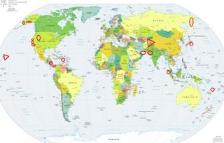
LEGEND for OVERVIEW:
Size = My surety of area for quake.
Red Circle = Probable quake to STRONG quake.
Triangle = Very Strong or Stronger quake (And usually takes extra days).
Blue Circle, etc. = Uncertainty of symptom area for probable quake.

Places to watch.
Good luck to all.
For Sunday, 12 March 2006.
----------------------------------------
Northeastern Russia/Kamchatka area
----------------------------------------
2006-03-12 15:15:38.1 57.35N 120.93E 10 Ms3.6 SOUTHEASTERN SIBERIA, RUSSIA
(Not North)
The Parkfield Fault
----------------------------------------
MAP 1.2 2006/03/11 08:27:13 36.031 -120.596 5.0 21 km ( 13 mi) NW of Parkfield, CA
MAP 2.3 2006/03/11 08:25:43 36.035 -120.597 4.8 21 km ( 13 mi) NW of Parkfield, CA
MAP 2.3 2006/03/12 10:17:13 36.558 -121.148 5.3 3 km ( 2 mi) N of Pinnacles, CA
MAP 1.0 2006/03/12 11:12:46 36.728 -121.203 5.4 13 km ( 8 mi) SE of Tres Pinos, CA
MAP 1.2 2006/03/12 14:07:46 36.981 -121.639 4.8 6 km ( 4 mi) WSW of Gilroy, CA
MAP 1.9 2006/03/12 19:02:20 36.558 -121.150 5.7 3 km ( 2 mi) N of Pinnacles, CA
MAP 2.0 2006/03/12 21:31:15 36.470 -121.048 5.5 11 km ( 7 mi) SE of Pinnacles, CA
MAP 1.4 2006/03/12 22:09:28 36.468 -121.043 5.7 11 km ( 7 mi) SE of Pinnacles, CA
Utah/Wyoming/Idaho area
----------------------------------------
MAP 1.6 2006/03/12 01:10:32 39.411 -111.215 2.4 23 km ( 14 mi) WNW of Huntington, UT
MAP 2.6 2006/03/12 03:01:22 39.614 -110.404 1.3 7 km ( 4 mi) N of Sunnyside, UT
MAP 2.6 2006/03/12 03:01:22 39.614 -110.404 1.3 7 km ( 4 mi) N of Sunnyside, UT
MAP 1.4 2006/03/12 04:59:49 39.735 -110.732 0.6 12 km ( 7 mi) ENE of Helper, UT
MAP 1.6 2006/03/12 11:51:10 39.671 -110.513 1.5 16 km ( 10 mi) NW of Sunnyside, UT
MAP 1.6 2006/03/12 20:10:50 39.608 -110.395 0.9 6 km ( 4 mi) N of Sunnyside, UT
MAP 1.6 2006/03/12 22:24:37 39.410 -111.216 7.1 23 km ( 14 mi) WNW of Huntington, UT
San Francisco area
----------------------------------------
MAP 1.4 2006/03/13 21:27:40 37.980 -122.039 12.1 2 km ( 2 mi) WNW of Concord, CA
MAP 2.3 2006/03/13 22:08:07 38.055 -121.675 6.1 5 km ( 3 mi) NW of Bethel Island, CA
Panama/Colombia area then Nicaragua/Costa Rica area
----------------------------------------
06/03/12 17:39:06 14.20N 90.07W 33.0 4.2ML Guatemala
06/03/12 14:11:19 12.13N 86.85W 70.0 3.2MC Frente a Puerto Sandino
06/03/12 12:34:47 12.68N 88.24W 68.5 3.3MC Frente al Golfo de Fonseca
06/03/12 10:22:09 12.22N 88.29W 138.9 2.8ML Oceano Pacífico de Nicaragua
06/03/12 09:04:00 11.03N 86.76W 66.1 3.0MC Frente a El Astillero
06/03/12 00:28:07 10.80N 86.42W 71.3 3.4ML Frente a San Juan del Sur
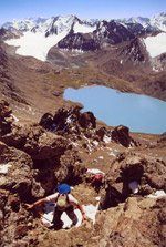
Kyrgyzstan/Afghanistan/Tajikistan border meeting (This is EXTREMELY STRONG for this area and there are other areas that will be affected. I believe this will be a series of quakes to increase the height of the Alai Mountain Range and others in this area of Asia. 3 tectonic plates meet here.)
http://www.fantasticasia.net/?p=6krange>FantasticAsia

----------------------------------------
(There was a large quake on the 13th but the symptoms I had makes me think that more and possibly bigger movement will happen in the area - until the 17th, stay prepared.)
SE of Tuntutuliak, AK (60.278 -162.581) then Alaska Peninsula
----------------------------------------
MAP 3.5 2006/03/12 10:19:23 53.556 -163.246 50.0 UNIMAK ISLAND REGION, ALASKA
MAP 2.5 2006/03/12 16:27:52 60.493 -151.320 20.0 KENAI PENINSULA, ALASKA
MAP 3.0 2006/03/12 21:36:27 58.785 -154.781 160.0 Alaska Peninsula
MAP 3.9 2006/03/13 05:28:00 57.849 -138.990 1.0 160 km ( 99 mi) WSW of Elfin Cove, AK
(This may be the first area I posted for - not sure of the symptom)
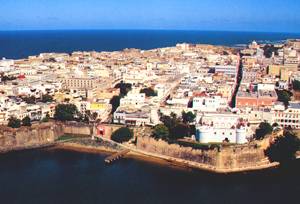
Puerto Rico area (Extremely Strong - Since I got very few symptoms for the bunch of quakes that recently happened in this area, I am giving the symptoms for this area more attention.)
PuertoRico
Muralla, Puerto Rico

----------------------------------------
MAP 2.1 2006/03/11 04:15:06 17.837 -67.039 45.4 15 km ( 9 mi) S of La Parguera, PR
MAP 3.0 2006/03/11 08:26:20 18.152 -67.231 101.2 9 km ( 6 mi) NNW of Puerto Real, PR
MAP 3.4 2006/03/11 11:34:49 18.994 -63.711 22.2 71 km ( 44 mi) ENE of Settlement, British Virgin Islands
MAP 2.6 2006/03/12 02:46:25 18.176 -64.954 6.3 19 km ( 12 mi) SSW of Anna's Retreat, US Virgin Islands
Honshu, Japan
----------------------------------------
2006-03-12 11:05:19.8 36.92N 141.03E 240 mb4.0 NEAR E.CST EASTERN HONSHU
2006-03-13 06:55:58 5.1 36.96N 140.56E Near East Coast of Honshu, Japan
2006-03-13 04:15:33 5.3 36.11N 141.29E Near East Coast of Honshu, Japan
2006-03-13 04:06:19 5.1 36.57N 141.35E Near East Coast of Honshu, Japan
2006-03-13 03:00:35 5.1 35.36N 141.89E Near East Coast of Honshu, Japan
Southern Pakistan/India border area then Southern Pakistan/Iran border area (2 different symptoms - STRONG)
----------------------------------------
(Nothing found for either area)
Northern Sumatra (1.75N 97.29E) (Strong)
----------------------------------------
2006-03-11 16:22:06.0 2.65N 95.81E 10 mb5.1 OFF W. CST OF NORTHERN SUMATERA
2006-03-12 16:52:43 5.0 9.83 N 91.03 E Nicobar Islands, India Region
2006-03-12 19:44:51 5.1 1.73 N 97.02 E Northern Sumatra, Indonesia
2006-03-12 22:59:17 5.2 14.25 N 93.53 E Andaman Islands, India Region
Vanuatu Islands (16.59S 168.13)
----------------------------------------
2006-03-12 07:12:29 5.1 14.86 S 167.90 E Vanuatu Islands
Naalehu, Hawaii (18.901 -155.200) (3 different symptoms - VERY STRONG)
http://www.lanierbb.com/search/display.php3?id=11259&pt=bb&item=4&arg=gallery#>MacadamiaMeadows

----------------------------------------
MAP 1.8 2006/03/12 05:23:40 19.512 -155.473 12.6 26 km ( 16 mi) WNW of Volcano, HI
MAP 2.7 2006/03/12 14:17:17 19.366 -155.078 8.3 13 km ( 8 mi) SSE of Fern Forest, HI
MAP 2.4 2006/03/12 19:10:09 19.384 -155.281 2.8 9 km ( 5 mi) SSW of Volcano, HI
MAP 2.4 2006/03/12 19:28:39 20.099 -156.654 3.2 69 km ( 43 mi) SSW of Wailea-Makena, HI
MAP 1.8 2006/03/12 20:42:11 19.396 -155.256 1.4 6 km ( 4 mi) SSW of Volcano, HI
Los Angeles and South of
----------------------------------------
MAP 2.2 2006/03/12 05:36:42 34.014 -117.581 4.3 6 km ( 4 mi) SE of Ontario, CA
MAP 3.1 2006/03/12 06:26:41 32.827 -118.342 3.2 34 km ( 21 mi) SE of San Clemente Is., CA (NW tip)
MAP 2.8 2006/03/12 06:43:56 32.831 -118.342 0.9 33 km ( 21 mi) SE of San Clemente Is., CA (NW tip)
MAP 2.7 2006/03/13 01:40:40 33.808 -119.424 2.8 43 km ( 27 mi) SSW of Channel Islands Beach, CA
MAP 3.2 2006/03/14 01:41:46 33.822 -119.428 6.5 42 km ( 26 mi) SSW of Channel Islands Beach, CA
Peace to all.

