*For Thursday, 11 May 2006.
LEGEND for OVERVIEW: Size = My surety of area for quake.
Red Circle = Probable quake to STRONG quake.
Triangle = Very Strong or Stronger quake (And usually takes extra days).
Blue Circle, etc. = Uncertainty of symptom area for probable quake.
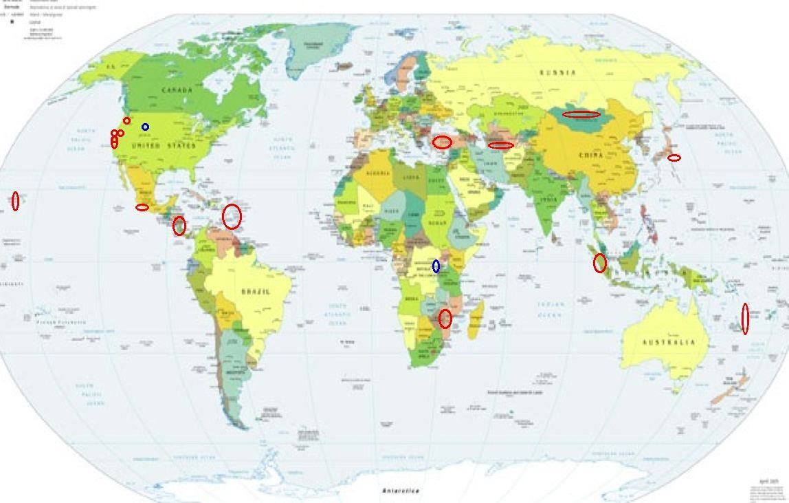
Places to watch.
Good luck to all.
For Thursday, 11 May 2006.
----------------------------------------
Puerto Rico/Virgin Islands
----------------------------------------
MAP 3.1 2006/05/11 07:36:51 18.671 -64.603 3.1 24 km ( 15 mi) N of East End-Long Look, British Virgin Islands
MAP 3.0 2006/05/11 08:15:01 18.989 -65.021 22.6 70 km ( 44 mi) NNW of Little Harbour, British Virgin Islands
MAP 3.0 2006/05/11 08:13:58 18.961 -65.021 28.0 68 km ( 42 mi) NNW of Little Harbour, British Virgin Islands
MAP 3.0 2006/05/11 08:11:26 18.959 -65.016 29.6 67 km ( 42 mi) NNW of Little Harbour, British Virgin Islands
MAP 3.0 2006/05/11 23:07:54 18.967 -65.005 29.5 67 km ( 42 mi) NNW of Little Harbour, British Virgin Islands
Possibly LAKE TANGANYIKA REGION (6.96 S 29.80 E) (Unproven symptom - Strong)
----------------------------------------
(Nothing found)
Honshu, Japan area
----------------------------------------
2006/05/10,01:23 36.1 N 139.9 E 50 km Mj 4.1 SW_IBARAKI_PREF 92.92
Guererro, Mexico area (Strong)
----------------------------------------
2006-05-10 18:04:59.7 14.66 N 92.45 W 79 M 4.6 NEAR COAST OF CHIAPAS, MEXICO
MAP 4.1 2006/05/11 11:02:58 24.378 -108.556 45.4 98 km ( 61 mi) WSW of Navolato, Mexico
Hawaii (STRONG)
----------------------------------------
MAP 2.1 2006/05/11 07:25:04 19.484 -154.893 0.0 3 km ( 2 mi) ENE of Leilani Estates, HI
MAP 2.2 2006/05/11 09:26:10 19.386 -155.239 1.8 7 km ( 4 mi) S of Volcano, HI
Possibly W. Yellowstone, Mt. (44.740N 111.105W) (Indication of depth and 2 different symptoms - Strong)
----------------------------------------
MAP 1.2 2006/05/11 11:24:55 46.824 -112.751 6.1 16 km ( 10 mi) SSW of Lincoln, MT
MAP 1.1 2006/05/11 12:07:38 45.291 -112.576 0.0 10 km ( 6 mi) NNE of Dillon, MT
Turkey (STRONG)
----------------------------------------
2006-05-11 01:18:10.5 40.15 N 36.87 E 5 MD 3.3 TURKEY
2006-05-11 01:15:14.0 39.00 N 30.01 E 13 MD 2.7 TURKEY
2006-05-11 05:41:36.0 40.85 N 33.80 E 21 MD 3.1 TURKEY
2006-05-11 04:55:40.0 38.11 N 26.83 E 3 MD 3.3 AEGEAN SEA
2006-05-11 04:53:07.9 40.38 N 28.34 E 6 MD 2.9 TURKEY
2006-05-11 03:02:05.3 38.62 N 39.88 E 25 MD 3.2 TURKEY
2006-05-11 05:41:36.0 40.85 N 33.80 E 21 MD 3.1 TURKEY
2006-05-11 15:11:26.4 37.24 N 28.16 E 5 MD 2.7 TURKEY
2006-05-11 16:07:43.6 40.11 N 27.89 E 25 MD 2.7 TURKEY
2006-05-11 21:49:14.6 38.45 N 31.87 E 6 MD 2.9 TURKEY
2006-05-11 21:30:49.3 38.15 N 27.35 E 18 MD 3.0 TURKEY
Turkmenistan area (38.80 N 59.40 E) (Strong)
----------------------------------------
2006-05-11 20:00:19.0 40.12 N 68.34 E ML 3.8 SOUTHEASTERN UZBEKISTAN
The Geysers
----------------------------------------
MAP 1.5 2006/05/11 00:49:26 38.818 -122.817 3.5 2 km ( 1 mi) NNW of The Geysers, CA
MAP 1.9 2006/05/11 00:38:06 38.775 -122.755 1.0 5 km ( 3 mi) ESE of The Geysers, CA
MAP 1.2 2006/05/11 00:32:03 38.802 -122.802 4.5 1 km ( 0 mi) NE of The Geysers, CA
MAP 2.0 2006/05/11 01:53:30 38.824 -122.829 3.1 3 km ( 2 mi) NW of The Geysers, CA
MAP 1.8 2006/05/11 05:57:01 38.797 -122.797 1.9 1 km ( 1 mi) E of The Geysers, CA
MAP 2.1 2006/05/11 08:58:16 38.800 -122.806 4.4 0 km ( 0 mi) NNE of The Geysers, CA
MAP 1.5 2006/05/11 08:57:58 38.803 -122.803 4.5 1 km ( 0 mi) NNE of The Geysers, CA
MAP 1.8 2006/05/11 12:29:50 38.796 -122.763 1.8 4 km ( 2 mi) E of The Geysers, CA
MAP 1.6 2006/05/11 19:37:57 38.809 -122.790 2.3 2 km ( 1 mi) NE of The Geysers, CA
MAP 1.4 2006/05/11 19:47:51 38.811 -122.800 3.4 2 km ( 1 mi) NNE of The Geysers, CA
MAP 1.6 2006/05/11 20:40:56 38.805 -122.815 4.4 1 km ( 1 mi) NW of The Geysers, CA
MAP 1.6 2006/05/11 20:33:16 38.810 -122.815 4.3 2 km ( 1 mi) NNW of The Geysers, CA
MAP 3.1 2006/05/11 20:28:51 38.807 -122.814 1.1 1 km ( 1 mi) NNW of The Geysers, CA
MAP 1.9 2006/05/11 21:22:56 38.812 -122.818 3.4 2 km ( 1 mi) NNW of The Geysers, CA
MAP 2.0 2006/05/11 23:48:13 38.800 -122.812 4.6 1 km ( 0 mi) WNW of The Geysers, CA
MAP 1.7 2006/05/11 23:42:22 38.779 -122.755 1.3 5 km ( 3 mi) ESE of The Geysers, CA
MAP 1.5 2006/05/12 00:26:56 38.808 -122.819 4.5 2 km ( 1 mi) NW of The Geysers, CA
MAP 1.7 2006/05/12 06:00:28 38.800 -122.811 2.3 0 km ( 0 mi) WNW of The Geysers, CA
MAP 2.0 2006/05/12 06:27:42 38.819 -122.786 1.8 3 km ( 2 mi) NE of The Geysers, CA
MAP 1.9 2006/05/12 11:09:21 38.821 -122.811 4.4 3 km ( 2 mi) N of The Geysers, CA
MAP 1.8 2006/05/12 11:08:17 38.840 -122.821 0.0 5 km ( 3 mi) NNW of The Geysers, CA
MAP 1.6 2006/05/12 10:52:17 38.800 -122.800 3.1 1 km ( 0 mi) ENE of The Geysers, CA
MAP 2.0 2006/05/12 10:47:43 38.829 -122.799 2.7 3 km ( 2 mi) NNE of The Geysers, CA
MAP 1.7 2006/05/12 10:47:31 38.814 -122.775 3.1 3 km ( 2 mi) ENE of The Geysers, CA
MAP 1.6 2006/05/12 10:45:30 38.810 -122.802 0.0 1 km ( 1 mi) NNE of The Geysers, CA
MAP 1.8 2006/05/12 10:43:48 38.800 -122.825 0.0 2 km ( 1 mi) W of The Geysers, CA
MAP 2.3 2006/05/12 10:43:17 38.837 -122.834 2.7 5 km ( 3 mi) NNW of The Geysers, CA
MAP 1.8 2006/05/12 10:42:51 38.828 -122.805 3.4 3 km ( 2 mi) N of The Geysers, CA
MAP 4.4 2006/05/12 10:37:29 38.814 -122.814 4.5 2 km ( 1 mi) NNW of The Geysers, CA
MAP 1.5 2006/05/12 12:16:01 38.828 -122.809 2.2 3 km ( 2 mi) N of The Geysers, CA
MAP 1.8 2006/05/12 12:06:42 38.838 -122.822 1.9 5 km ( 3 mi) NNW of The Geysers, CA
MAP 1.6 2006/05/12 12:05:29 38.821 -122.809 3.4 2 km ( 2 mi) N of The Geysers, CA
MAP 1.9 2006/05/12 12:03:29 38.801 -122.805 1.8 0 km ( 0 mi) NNE of The Geysers, CA
MAP 1.9 2006/05/12 11:56:12 38.820 -122.811 4.5 2 km ( 2 mi) N of The Geysers, CA
MAP 1.9 2006/05/12 11:48:16 38.819 -122.811 3.2 2 km ( 1 mi) N of The Geysers, CA
MAP 1.5 2006/05/12 11:41:14 38.822 -122.811 4.2 3 km ( 2 mi) N of The Geysers, CA
MAP 1.5 2006/05/12 11:40:42 38.803 -122.814 4.4 1 km ( 1 mi) NW of The Geysers, CA
MAP 1.7 2006/05/12 11:40:18 38.801 -122.805 3.8 0 km ( 0 mi) NNE of The Geysers, CA
MAP 1.4 2006/05/12 11:29:48 38.825 -122.818 2.7 3 km ( 2 mi) NNW of The Geysers, CA
MAP 1.7 2006/05/12 11:28:30 38.838 -122.830 0.5 5 km ( 3 mi) NNW of The Geysers, CA
MAP 1.4 2006/05/12 12:39:21 38.822 -122.811 4.5 3 km ( 2 mi) N of The Geysers, CA
MAP 2.0 2006/05/12 12:33:26 38.865 -122.800 3.9 7 km ( 5 mi) N of The Geysers, CA
MAP 2.9 2006/05/12 12:24:38 38.817 -122.815 4.5 2 km ( 1 mi) NNW of The Geysers, CA
MAP 1.7 2006/05/12 13:28:39 38.823 -122.799 4.5 3 km ( 2 mi) NNE of The Geysers, CA
MAP 1.4 2006/05/12 13:41:48 38.824 -122.799 4.5 3 km ( 2 mi) NNE of The Geysers, CA
MAP 1.9 2006/05/12 14:35:22 38.821 -122.811 4.3 3 km ( 2 mi) N of The Geysers, CA
MAP 1.6 2006/05/12 14:34:35 38.799 -122.810 3.2 0 km ( 0 mi) WNW of The Geysers, CA
MAP 1.5 2006/05/12 14:34:14 38.822 -122.810 4.3 3 km ( 2 mi) N of The Geysers, CA
MAP 1.4 2006/05/12 14:19:23 38.817 -122.799 2.8 2 km ( 1 mi) NNE of The Geysers, CA
MAP 1.3 2006/05/12 17:06:15 38.821 -122.811 4.4 3 km ( 2 mi) N of The Geysers, CA
MAP 2.1 2006/05/12 16:27:31 38.824 -122.796 3.1 3 km ( 2 mi) NNE of The Geysers, CA
MAP 1.5 2006/05/12 16:20:42 38.824 -122.799 4.2 3 km ( 2 mi) NNE of The Geysers, CA
MAP 1.5 2006/05/12 19:07:46 38.819 -122.816 3.9 2 km ( 2 mi) NNW of The Geysers, CA
MAP 1.8 2006/05/12 19:13:12 38.855 -122.819 2.1 6 km ( 4 mi) N of The Geysers, CA
MAP 1.4 2006/05/12 20:26:07 38.808 -122.818 3.8 1 km ( 1 mi) NW of The Geysers, CA
MAP 2.1 2006/05/12 22:51:22 38.821 -122.786 2.7 3 km ( 2 mi) NE of The Geysers, CA
MAP 1.2 2006/05/12 23:44:52 38.824 -122.809 4.4 3 km ( 2 mi) N of The Geysers, CA
Mongolia area (44.66 N 102.50 E) (Medium)
----------------------------------------
(Nothing found)
Mt. St. Helen’s
----------------------------------------
MAP 1.7 2006/05/11 00:46:02 46.194 -122.195 0.2 1 km ( 1 mi) WSW of Mount St. Helens Volcano, WA
MAP 1.7 2006/05/11 08:06:27 46.197 -122.195 1.0 1 km ( 1 mi) WSW of Mount St. Helens Volcano, WA
MAP 2.1 2006/05/11 16:24:14 46.194 -122.206 0.0 2 km ( 1 mi) WSW of Mount St. Helens Volcano, WA
MAP 1.0 2006/05/11 17:24:07 46.195 -122.197 0.9 1 km ( 1 mi) WSW of Mount St. Helens Volcano, WA
Boulder Creek, California area (37.222 -122.116) (Second day of symptom - STRONG).
----------------------------------------
MAP 1.7Q 2006/05/11 21:00:06 37.325 -122.108 0.0 0 km ( 0 mi) WSW of Quarry near Cupertino, CA(Probable quarry explosion)
MAP 1.0 2006/05/11 18:48:04 37.013 -122.145 8.8 9 km ( 6 mi) WSW of Felton, CA
MAP 1.0 2006/05/11 03:53:57 37.940 -122.063 9.5 2 km ( 1 mi) SSE of Pleasant Hill, CA
Mozambique area
----------------------------------------
(Came in on the 12th and 15th and posted on the 12th.)
San Francisco Bay
----------------------------------------
MAP 1.7 2006/05/10 18:47:23 37.979 -122.475 2.1 4 km ( 3 mi) E of San Rafael, CA
MAP 1.0 2006/05/11 03:53:57 37.940 -122.063 9.5 2 km ( 1 mi) SSE of Pleasant Hill, CA
MAP 1.7Q 2006/05/11 21:00:06 37.325 -122.108 0.0 0 km ( 0 mi) WSW of Quarry near Cupertino, CA(Probable quarry explosion)
Vanuatu area(13.72 S 167.84 E)
----------------------------------------
11May2006 17:56:11.5 20.7S 169.0E 33 mb=5.4 M GSR VANUATU ISLANDS
Sumatra
----------------------------------------
2006-05-11 17:04:37 5.3 3.30 S 102.27 E Southern Sumatra, Indonesia
Petrolia area
----------------------------------------
map 1.9 2006/05/10 16:10:08 40.627N 124.174W 13.5 5 km ( 3 mi) NNW of Fortuna, CA
Nicaragua/Costa Rica area (Vo.lcanic) (Medium)
----------------------------------------
06/05/11 21:27:49 12.79N 86.65W 1.0 1.3ML Nicaragua
06/05/11 19:43:54 10.99N 86.83W 10.3 3.0ML Frente a La Boquita y Casares
06/05/11 06:37:23 11.43N 87.40W 10.5 2.9MC Frente a Puerto Sandino
06/05/11 03:12:02 9.72N 83.86W 10.1 4.2MC Costa Rica
Peace to all.

posted by Unknown @ 2:49 PM
0 comments
![]()
![]()
