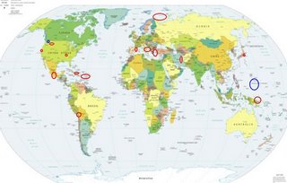
*For Thursday, 21 September 2006.
LEGEND for OVERVIEW: Size = My surety of area for quake.
Red Circle = Probable quake to STRONG quake.
Triangle = Very Strong/Stronger quake (Usually takes extra days).
Blue Circle, etc. = Uncertainty of symptom area for probable quake.

Places to watch.
Good luck to all.
For Thursday, 21 September 2006.
---------------------------------------
The Pyrenees/France-Spain border
on Mediterranean side (Strong)
---------------------------------------
2006-09-21 06:57:33.2 44.56N 6.84E 2 ML2.6 FRANCE
2006-09-21 18:15:56.1 49.47N 0.03E 10 ML3.1 FRANCE
Montana/Idaho
---------------------------------------
06/09/21 19:46:30 44.61N 110.67W 3.6 1.6 8.5 mi SSE of Norris Junc.
Aegean Sea/Turkey area
---------------------------------------
2006-09-21 00:15:36.2 38.52N 20.48E 10 G ML2.7 GREECE
2006-09-21 05:32:05.3 36.84N 28.10E 69 ML3.0 DODECANESE ISLANDS, GREECE
2006-09-21 09:42:25.3 37.08N 38.78E 10 MD3.1 TURKEY
2006-09-21 21:27:36.5 37.37N 36.42E 5 MD3.0 TURKEY
2006-09-21 21:07:52.3 32.04N 35.43E 2 Mw3.9 DEAD SEA REGION
2006-09-21 23:46:12.0 39.80N 21.80E ML2.8 GREECE
The New Madrid Fault
---------------------------------------
(Nothing found)
Southern Mexico
---------------------------------------
2006/09/21 01:19:53 17.07 100.05 38 3.4 8 km al NORESTE de COYUCA DE BENITEZ, GRO
2006/09/21 03:34:45 16.38 98.48 49 4.0 34 km al SUR de OMETEPEC, GRO
2006/09/21 08:34:03 17.07 100.13 2 3.4 8km al NOROESTE deCOYUCA DE BENITEZ, GRO
2006/09/21 09:24:13 17.75 94.75 137 3.9 24 km al SUR de JALTIPAN DEMORELOS, VER
2006/09/21 09:32:18 15.68 98.01 9 3.9 71 km al SUROESTE de RIO GRANDE, OAX
2006/09/22 02:38:54 14.71 94.40 29 4.4 167 km al SUROESTE de TONALA, CHIS
Barents Sea area (75.92 19.96)
---------------------------------------
WESTERN BARENTS SEA
Origin time Lat Lon Azres Timres Wres Nphase Ntot Nsta Netmag
2006-263:11.18.10.0 74.94 25.36 6.67 4.07 5.74 4 6 2 2.56
BARENTS SEA
Origin time Lat Lon Azres Timres Wres Nphase Ntot Nsta Netmag
2006-263:12.39.47.0 74.36 48.61 10.40 0.06 2.66 2 2 1 2.34
BARENTS SEA
Origin time Lat Lon Azres Timres Wres Nphase Ntot Nsta Netmag
2006-263:13.31.13.0 77.54 62.33 16.95 0.06 4.30 2 2 1 2.35
Honshu, Japan (medium)
---------------------------------------
(Nothing found)
Bismarck Sea (4.76S 149.05E)(Medium)
---------------------------------------
(Nothing found)
Possibly Entiat, WA area (47.680 -120.324)
(Second day symptom for same area. Still
trying to pinpoint Washington State - Strong)
---------------------------------------
1.2 2006/09/21 00:15:06 46.170 -119.654 8.3 10 km ( 6 mi) ESE of Prosser, WA
1.9 2006/09/21 03:27:27 47.555 -121.860 23.4 3 km ( 2 mi) NNW of Snoqualmie, WA
TARAPACA, CHILE (19.23S 69.13W)
---------------------------------------
2006-09-22 02:32:22.1 26.81S 63.04W 562 mb5.9 SANTIAGO DEL ESTERO ARGENTINA
Pleasant Hill, CA area (37.950 -122.090)
---------------------------------------
(Nothing found)
Possibly Guam or Caroline Islands or
maybe another symptom for Bismarck Sea
already posted (Unproven symptom but strong
with indication of depth - STRONG)
---------------------------------------
22Sep2006 02:29:49.4 33.2S 141.1W 30 mb=6.2 A ROM SOUTH PACIFIC OCEAN ???
(Symptom strength fits but also posted for 20th September symptom where area fits - possibly both symptoms for same area)
Central Italy/Southern Italy
---------------------------------------
2006-09-20 00:20:47.0 38.66N 13.04E 27 ML3.4 SICILY, ITALY
2006-09-20 16:16:59.0 38.09N 15.13E 17 ML2.6 SICILY, ITALY
2006-09-20 23:22:16.0 40.02N 16.26E 26 ML2.6 SOUTHERN ITALY
2006-09-20 23:51:08.0 37.82N 14.93E 27 ML2.7 SICILY, ITALY
Iran (Strong)
---------------------------------------
2006-09-20 23:56:13.7 36.69N 57.83E 18 M3.3 NORTHERN AND CENTRAL IRAN
2006-09-20 19:34:02.8 31.08N 57.09E 27 M3.2 NORTHERN AND CENTRAL IRAN
2006-09-20 04:45:01.6 36.80N 55.42E 10 M3.6 NORTHERN AND CENTRAL IRAN
2006-09-21 00:24:49.9 36.52N 57.57E 18 M3.1 NORTHERN AND CENTRAL IRAN
2006-09-22 15:40:52.4 36.59N 57.77E 18 mb4.2 NORTHERN AND CENTRAL IRAN
2006-09-22 15:37:50.7 36.51N 57.60E M3.2 NORTHERN AND CENTRAL IRAN
Dominican Republic/Puerto Rico area
then Virgin Islands area
---------------------------------------
3.1 2006/09/21 22:27:44 17.900N -67.245W 132.0 10 km ( 6 mi) SW of Pole Ojea, PR
3.6 2006/09/21 17:01:16 18.837N -64.475W 24.8 20 km (13 mi) NW of Settlement, Anegada, British Virgin Islands
2.9 2006/09/21 14:49:30 19.012N -68.106W 35.2 77 km (48 mi) NE of Higüey, La Altagracia, Dominican Republic
2.9 2006/09/21 00:52:46 18.976N -68.483W 1.3 46 km (29 mi) NNE of Higüey, La Altagracia, Dominican Republic
3.0 2006/09/22 23:48:40 18.683N -65.133W 6.1 42 km (26 mi) NNW of Charlotte Amalie, Saint Thomas, US Virgin Islands
3.6 2006/09/22 21:29:44 17.624N -68.905W 121.1 90 km (56 mi) S of La Romana, La Romana, Dominican Republic
3.7 2006/09/22 10:27:16 19.112N -68.964W 188.7 39 km (24 mi) NNE of El Seybo, El Seybo, Dominican Republic
4.8 2006/09/22 09:49:07 22.992N -64.157W 176.2 474 km (295 mi) N of Settlement, Anegada, British Virgin Islands
3.4 2006/09/22 08:06:03 18.625N -64.554W 25.2 18 km (11 mi) N of East End-Long Look, Tortola, British Virgin Islands
3.9 2006/09/22 02:43:55 19.368N -68.706W 14.9 68 km (42 mi) ENE of Samaná, Samaná, Dominican Republic
Peace to all.

