*For Saturday, 3 June 2006.
LEGEND for OVERVIEW: Size = My surety of area for quake.
Red Circle = Probable quake to STRONG quake.
Triangle = Very Strong or Stronger quake (And usually takes extra days).
Blue Circle, etc. = Uncertainty of symptom area for probable quake.
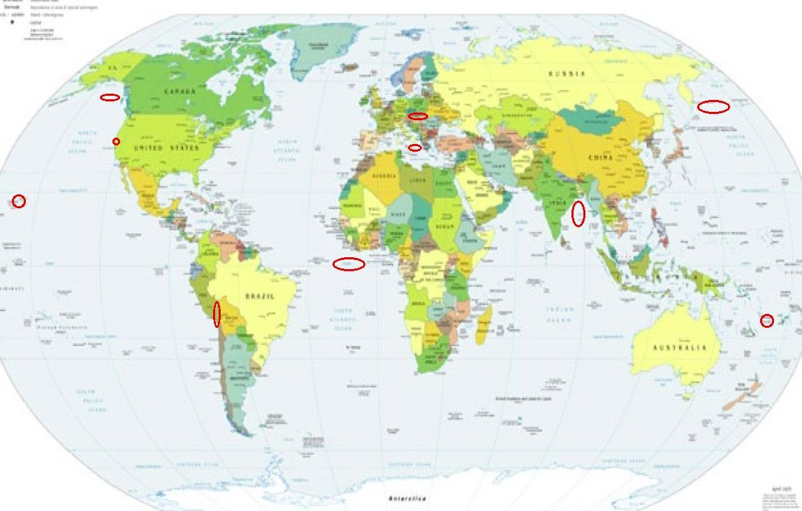
Places to watch.
Good luck to all.
For Saturday, 3 June 2006.
----------------------------------------
Hawaii
----------------------------------------
(Nothing found)
Czech and Slovak Republics area (49.96N 18.29E)
----------------------------------------
2006-06-02 16:28:12.4 49.80 N 18.43 E 8 ML 2.5 CZECH AND SLOVAK REPUBLICS
2006-06-03 13:44:38 2.5 49.64 N 14.24 E Czech And Slovak Republics
2006-06-04 08:57:43 2.4 49.47 N 14.06 E Czech And Slovak Republics
Sicily, Italy/Ionian Sea
----------------------------------------
2006-06-03 18:44:33.0 41.87 N 15.86 E 20 ML 2.7 SOUTHERN ITALY
Off the Coast of Kamchatka area (53.05 N 159.90 E)
----------------------------------------
2006-06-04 02:31:15.0 53.92 N 159.43 E 90 M 4.6 NEAR E. CST KAMCHATKA PEN.
2006-06-04 04:03:16.1 46.65 N 146.89 E 318 mb 4.3 NW. KURIL ISLANDS, RUSSIA
Peru-Bolivia border region (17.23 S 69.37 W) (2 different symptoms - Strong)
----------------------------------------
(Nothing found)
Vanuatu Islands (15.26 S 167.22 E) (Strong)
----------------------------------------
2006-06-03 19:09:46.7 15.39 S 167.97 E 33 mb 5.1 VANUATU ISLANDS
Bay of Bengal area
----------------------------------------
2006-06-03 13:01:15.7 13.14 N 92.59 E 60 mb 4.9 ANDAMAN ISLANDS,INDIA, REG
Gulf of Alaska (Medium)
----------------------------------------
MAP 4.5 2006/06/02 09:38:26 55.463 -156.004 50.0 SOUTH OF ALASKA
MAP 4.3 2006/06/02 10:30:48 55.463 -156.004 50.0 SOUTH OF ALASKA
MAP 4.2 2006/06/02 11:18:51 55.198 -155.786 15.0 SOUTH OF ALASKA
MAP 4.3 2006/06/03 10:54:22 55.198 -155.786 15.0 SOUTH OF ALASKA
MAP 3.6 2006/06/03 15:07:18 58.292 -145.498 15.0 GULF OF ALASKA
San Francisco area/Possibly San Jose
----------------------------------------
MAP 1.5 2006/06/02 18:31:21 37.980 -122.474 0.3 4 km ( 3 mi) E of San Rafael, CA
MAP 1.8Q 2006/06/05 21:05:52 37.324 -122.106 0.0 0 km ( 0 mi) SW of Quarry near Cupertino, CA(Probable quarry explosion)
(2 extra days)
MAP 2.0 2006/06/06 00:26:29 37.892 -121.772 17.1 7 km ( 5 mi) SW of Brentwood, CA
MAP 1.4 2006/06/06 08:23:50 37.356 -121.720 8.6 9 km ( 6 mi) E of Alum Rock, CA
MAP 1.6 2006/06/06 08:23:06 37.356 -121.718 8.8 10 km ( 6 mi) E of Alum Rock, CA
MAP 2.1 2006/06/06 11:49:45 37.891 -121.771 17.7 7 km ( 5 mi) SW of Brentwood, CA
(3 extra days)
North of Ascension Island area (1.57 S 13.17 W) (Strong)
----------------------------------------
2006-06-05 06:34:34.3 1.12 N 28.16 W 33 mb 5.4 CENTRAL MID-ATLANTIC RIDGE
2006-06-05 06:27:10.2 0.63 N 28.16 W 33 f mb 5.2 CENTRAL MID-ATLANTIC RIDGE
2006-06-05 06:18:46.2 1.06 N 28.16 W 33 mb 5.0 CENTRAL MID-ATLANTIC RIDGE
(2 extra days and more West than expected)
Peace to all.

posted by Unknown @ 11:41 AM
0 comments
![]()
![]()
